Click to view article in PDF format.
Devonian
Shelf to Basin Facies Distributions and Preliminary Shale Geochemistry for
South-central and Southwestern New ![]() Mexico
Mexico![]() *
*
By
William D. Raatz1
Search and Discovery Article #10074 (2004)
*Adapted from extended abstract of presentation at Southwest Section, AAPG, Annual Meeting, Fort Worth, Texas, March 1-4, 2003
1New
![]() Mexico
Mexico![]() Bureau of Geology and Mineral Resources, a Division of New
Bureau of Geology and Mineral Resources, a Division of New ![]() Mexico
Mexico![]() Tech,
801 Leroy Place, Socorro, NM 87801 ([email protected])
Tech,
801 Leroy Place, Socorro, NM 87801 ([email protected])
Abstract
The often
poorly exposed Devonian section in southern New ![]() Mexico
Mexico![]() contains complex vertical
and lateral ramp-to-basin facies changes that culminate in an elongate trough
filled with up to 76 m of black shale. The trough trends east-west for over 350
km, and ranges from a width of ~30 km near Las Cruces to ~100 km near Deming. To
the north, Middle-Late Devonian-aged ramp carbonates, sandstones, siltstones,
and shales of the Oñate (Givetian), Sly Gap (Frasnian), and Contadero (Frasnian-Fammenian)
formations crop out in the San Andres and Sacramento mountains. These formations
grade southward into the Percha Formation black shale facies. Due to the largely
barren nature of the shales, it is difficult to determine exact correlations.
The Percha Formation is divided into two members, the black, fissile, barren
Ready Pay and the more calcareous and fossiliferous Box. Fossils from the upper
Box Member indicate a Fammenian age. South of the trough, the oldest Devonian
units comprise the cherty shelf carbonate Canutillo Formation (Middle-Late
Devonian), which is both overlain by, and apparently a partial lateral facies
equivalent to, the Percha black shales.
contains complex vertical
and lateral ramp-to-basin facies changes that culminate in an elongate trough
filled with up to 76 m of black shale. The trough trends east-west for over 350
km, and ranges from a width of ~30 km near Las Cruces to ~100 km near Deming. To
the north, Middle-Late Devonian-aged ramp carbonates, sandstones, siltstones,
and shales of the Oñate (Givetian), Sly Gap (Frasnian), and Contadero (Frasnian-Fammenian)
formations crop out in the San Andres and Sacramento mountains. These formations
grade southward into the Percha Formation black shale facies. Due to the largely
barren nature of the shales, it is difficult to determine exact correlations.
The Percha Formation is divided into two members, the black, fissile, barren
Ready Pay and the more calcareous and fossiliferous Box. Fossils from the upper
Box Member indicate a Fammenian age. South of the trough, the oldest Devonian
units comprise the cherty shelf carbonate Canutillo Formation (Middle-Late
Devonian), which is both overlain by, and apparently a partial lateral facies
equivalent to, the Percha black shales.
Existing 1960’s
vintage isopach and facies ![]() maps
maps![]() are updated with more recent outcrop and
subsurface data, and integrated with geochemical data and basin analysis models
to characterize better the areal extent, volume, richness, and maturity of the
black shale facies. Public-domain geochemical data show potential for the
Devonian shales in south-central and southwestern New
are updated with more recent outcrop and
subsurface data, and integrated with geochemical data and basin analysis models
to characterize better the areal extent, volume, richness, and maturity of the
black shale facies. Public-domain geochemical data show potential for the
Devonian shales in south-central and southwestern New ![]() Mexico
Mexico![]() to act as source
rocks: TOC values locally reach 3.7% and thermal maturities are consistently in
the mature to very mature range.
to act as source
rocks: TOC values locally reach 3.7% and thermal maturities are consistently in
the mature to very mature range.
Three goals exist for this ongoing project:
-
Better constraints on formation correlations and facies relationships
-
Improved characterization of Devonian shales for
 hydrocarbon
 source rock potential (richness and maturity
trends, kerogen types, and expulsion timing)
source rock potential (richness and maturity
trends, kerogen types, and expulsion timing)
Description of the shales for shale gas reservoir potential.
|
|
Table and Figure Captions
IntroductionThe
Devonian succession in southern and southwestern New
StratigraphyThe
Middle to Upper Devonian formations present in southern New
Interpretation of the environment of deposition responsible for the
anoxia and subsequent black shale deposition ranges from shallow lagoon
with algal mat covering (Seager, 1981; LeMone, 1982, 1996b; Mack et al.,
1998), to “deep water” with anoxia resulting from a density-stratified
seaway (Kottlowski et al., 1956; Sorauf, 1984; Day, 1988, 1998). The
“deep water” model better fits the general basin physiography of the
area and is the preferred interpretation. This “black shale problem” is
not restricted to southern New
Devonian formations are well established within individual mountain
ranges, although members continue to undergo revision, and correlation
between ranges is not always clear (see Kottlowski et al., 1956; Seager,
1981; Sorauf, 1984; Kottlowski and LeMone, 1994). The oldest Devonian
strata present in south-central New The Sly Gap Formation (Stevenson, 1945), of Frasnian age, disconformably overlies the Oñate (Pray, 1961; Day, 1988). It is present in the northern and central Sacramento Mountains, the entire San Andres Mountains, and is incorporated as part of the Percha Formation in the Organ/Franklin Mountains (Pray, 1961; Seager, 1981; Sorauf, 1984). It is interpreted to represent a transgressive-regressive succession deposited in shelf (Sacramento Mountains, northern San Andres Mountains) to basin (southern San Andres Mountains) environments (Day, 1988). In the Sacramento Mountains the Sly Gap Formation contains interbeds of calcareous shale, thin-to-nodular fossiliferous lime mudstone, and lesser black shale, weathering to a distinctive yellowish color (Pray, 1961). Laudon and Bowsher (1941, 1949), Stevenson (1945), and Pray (1961) considered various upper beds of black shale in the southern Sacramento Mountains as belonging to the Percha Formation, although other workers interpreted them as basin facies of the Sly Gap Formation (Kottlowski et al., 1956). In the San Andres Mountains the Sly Gap Formation consists of nodular interbeds of fossiliferous (colonial and solitary corals, brachiopods, crinoids, ammonoids, gastropods, stromatoporoids), calcareous, silty shale, silty limestone, and calcareous siltstone (Kottlowski et al., 1956; Sorauf, 1984; Kottlowski and LeMone, 1994). In the southern San Andres Mountains the Sly Gap is composed almost completely of dark gray to black shales deposited in anoxic environments (Kottlowski et al., 1956; Day, 1988). The Contadero Formation (Stevenson, 1945) is recognized in the northern San Andres Mountains and originally incorporated all strata between the Sly Gap and the Mississippian, but it was revised by Flower (in Kottlowski et al., 1956) to include what were originally upper Sly Gap units and also exclude upper dark shales with Fammenian fauna, which were placed in the Percha Formation. Sorauf (1984) revised Flower’s member nomenclature to include: the Salinas Peak Member (sea-level highstand shale to sandstone, with upper coral-bearing nodular limestone); Thurgood Sandstone Member (regressive, fine-grained, well indurated sandstone with calcareous cement and brachiopod fragments); and Rhodes Canyon Member (Fammenian-aged shales and burrowed siltstones with brachiopods, correlative to the Ready Pay Member of the Percha Formation). The Contadero Formation, which is not recognized in the Sacramento or the Franklin Mountains, may have formed in a narrow structural re-entrant largely limited to the San Andres Mountains area (Day, 1988). In the Organ/Franklin Mountains the Percha Formation is used to include all Middle-Upper Devonian shales above the Canutillo Formation, including strata that are age-equivalent to the Oñate, Sly Gap, and Contadero formations (Seager, 1981). To the north, when used at all, the Percha is constrained to only those dark shales of Fammenian age. The Percha is divided into two members: the Ready Pay (black, fissile, barren shale) and the Box (shale with nodular limestone concretions and limited fauna). As discussed, Pray (1961) considered the uppermost dark shales in the southern Sacramentos to be lower Percha, rather than Sly Gap, based partly on a dark shale “channel-filling” unit with angular contacts between the Sly Gap and Mississippian. Dark shales in the extreme southern Sacramento Mountains are variously interpreted as Percha or Sly Gap/Oñate basin equivalents (Kottlowski et al., 1956; Pray, 1961). Fammenian-aged shales in the San Andres Mountains are included in the Rhodes Canyon Member of the Contadero Formation (Sorauf, 1984). In
southwestern New
Organic GeochemistryOrganic
geochemistry data for Devonian units in south-central and southwestern
New
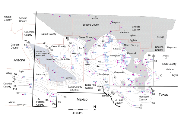
Burial HistoryBurial history and basin analysis studies are not common for this region. Two major problems exist in constructing accurate models: (1) data quantity and quality, and (2) the complex heat-flow history of this area that has experienced Ancestral Rocky Mountain tectonism, the Laramide orogeny, and Rio Grande rifting. Although a fair number of well penetrations exist (Table 1, Figure 1), most are of pre-1980 vintage (many significantly older) and contain generally poor log suites. Detailed bolson thickness data and structural styles are poorly constrained; lithologies and lithic percentages can often only be estimated; and formation and age picks are usually performed without the aid of biostratigraphic data or core. Geochemical and thermal data are rare.
Estimate of heat flow through time is a major variable in any burial
history model. The Rio Grande Rift area contains one of the more
complicated thermal regimes in the world. High-quality regional present-
day heat flow Even under ideal circumstances, basin models offer nonunique solutions that fit known data. Due to the data complexities discussed above, a single “best estimate” model is misleading for this area, since a greater than normal number of parameters are poorly constrained. I, therefore, provide two best fit end member models that hopefully bracket much of the area (Figures 5, 6, 7, and 8): (1) Grim Mobil-32 #1, a deep well test below 20,000 feet containing thick Tertiary Rio Grand Rift bolson valley fill but heat flow within regional norms, and (2) McGregor GDP 51-8, with much thinner bolson deposits but anomalously high heat flow.
Petroleum PotentialNumerous oil and gas shows and one significant gas discovery (Harvey E. Yates 1Y Bennett Ranch well, Sec. 14, T.26S., R.12E.) in the study area indicate an active petroleum system exists. Of 83 exploratory wells drilled in the Tularosa Basin, 25 contain shows. Despite this proven potential, the area’s large size, the multiple source and reservoir facies, and the complex structural history offering numerous trapping mechanisms, few integrated petroleum systems studies have been undertaken (e.g., Broadhead, 2002). A regional, comprehensive interpretation of this area’s petroleum system is needed to understand better its potential and to high-grade primary opportunities.
Source RocksSource
rocks have been documented for Devonian, Mississippian, Pennsylvanian,
and Permian strata (Broadhead, 2002), and for Cretaceous shales and
coals in central New
Expulsion timingFor the
Ancestral Rocky Mountain Orogrande and Pedregosa basin areas (e.g.,
central Tularosa Basin between the Sacramento and San Andres Mountains,
and in southwestern New
ReservoirsNumerous potential reservoir facies exist, including: fractured Precambrian basement, Cambro-Ordovician sandstones (Bliss Formation), karsted Ordovician carbonates (El Paso Formation), Silurian dolomites (Fusselman Formation), Devonian sandstones (northern area), Devonian shales (southern area), Mississippian carbonate bioherms (including large Waulsortian mounds), Pennsylvanian (Morrowan/Atokan) sandstones, Upper Pennsylvanian phylloid-algal mounds (correlative to the Holder Formation outcrops in the Sacramento Mountains), Lower Permian (Wolfcampian) basin margin mounds and breccia debris flows, Upper Permian (San Andres and Yeso Formation) backreef limestones and dolomites, Cretaceous sandstones (Dakota Formation) and coalbed methane, and Tertiary (Eocene) fractured igneous sills (the major reservoir for the Otero Mesa Harvey E. Yates gas discovery). Recovered fluids from existing wells include oil, gas, saline water, and fresh water.
Traps/sealsThe
large study area has undergone multiple tectonic episodes and also has
numerous documented stratigraphic pinch-outs, creating a wide range of
trapping styles and mechanisms, many analogous to the neighboring
prolific Permian Basin. Ancestral Rocky Mountain block faults, many
reactivated during Rio Grande Rift extension, potentially juxtapose
reservoir facies against units with low permeability or against fault
planes with clay smear/cataclasis effects. Structural roll-on horsts
near major normal faults also add dip closure. Low-angle Laramide thrust
faults and rollovers are documented in outcrop (e.g., Pray, 1961) and
the subsurface; for Seal integrity is a concern in the eastern Sacramento Mountain uplift area. Major fracture systems have breached some horst block units, flushing reservoirs with fresh water. This negative does create an opportunity for fresh-water exploration in this growing, water-starved area.
Preliminary Comments on Most Prospective AreasIntegrating previous studies and new work, the most prospective area for Devonian-sourced hydrocarbons appears to be the south-central portion of the study area, bounded approximately by the latitudes of Hatch to the north and El Paso to the south, and longitude of Deming to the west and extending eastward beyond the study area. This area has adequate organic richness, thermal maturity, reservoir intervals, and trapping mechanisms to create a viable petroleum (predominantly gas) system. To the north, Devonian organic richness lessens, due to the influx of shelf clastics; to the west source-rock richness decreases, due to unknown reasons and maturities increase to post mature. To the south richness decreases, due to a facies change into the cherty carbonate Canutillo Formation.
Conclusions
South-central New
AcknowledgmentsPRA
Inc. BasinMod 1-D was used for basin modeling. The New
References
Bayless, G.S., and Schwarzer, R.R., 1988,
Bowsher, A.L., 1967, The Devonian System of New
Broadhead, R.F., 2002, Petroleum geology of the McGregor
Range, Otero County, New
Broadhead, R.R., Wilks, M., Morgan, M., and Johnson, R.E.,
1998, New Brown, T.C., and Kenig, F., 2001, Continental scale intermittent photic zone euxinia during deposition of Devonian-Mississippian black shales of North America (abs.): Geological Society of America, Abstracts with Programs, v. 33, no. 6, p. 38.
Day, J.E., 1988, Stratigraphy, biostratigraphy, and
depositional history of the Givetian and Frasnian strata in the San
Andres and Sacramento Mountains of southern New
Day, J.E., 1998, Middle-Late Devonian transgressive-regressive
cycles in cratonic platform and platform-to-basin settings: San Andres
and Sacramento mountains, southern New
Foster, R.W., 1978, Oil and gas evaluation of White Sands
Missile Range and Fort Bliss Military Reservation, south-central New
Grabau, A.M., 1915, The black shale problem; a study in Paleozoic geography: Annals of the New York Academy of Sciences 24, p. 378-379.
Jacobson, S.R., Rankin. J.S., and Saxton, J.D., 1983,
Organic geochemical analysis, Houston Oil and Minerals No.2 Lewelling
Well, Otero County, New
Jacobson, S.R., Rankin. J.S., Saxton, J.D., and Ruth, G.W.,
1984, Organic geochemical analysis, Plymouth Oil Co. No. 1 Federal Well,
Otero County, New
Jacobson, R.A., Sweet, W.C., and Williams, M.R., 1984,
Organic geochemical analysis of the
Kottlowski, F.E., 1963, Paleozoic and Mesozoic strata of
southwestern and south-central New
Kottlowski, F.E., Flower, R.H., Thompson, M.L., and
Foster, R.W., 1956, Stratigraphic studies of the San Andres Mountains,
New Kottlowski, F.E., and LeMone, D.V., 1994, San Andres Mountains stratigraphy revisited, in Garber, R.A., and Keller, D.R., eds., Field guide to the Paleozoic section of the San Andres Mountains: Society of Economic Paleontologists and Mineralogists, Permian Basin, p. 31-45.
Laudon, L.R., and Bowsher, A.L., 1949, Mississippian
formations of southwestern New
LeMone, D.V., 1982, Stratigraphy of the Franklin
Mountains, El Paso County, Texas and Dona Ana County, New
LeMone, D.V., 1996, The Tobosa Basin-related stratigraphy
of the Franklin Mountains, Texas and New
Leutloff, A.H., and Curry, D.J., 1982, Petroleum
source-rock study of selected wells in the Rio Grande Rift area, New
Mack, G.H., Kottlowski, F.E., and Seager, W.R., 1998, The
stratigraphy of south-central New Nelson, L.A., 1940, Paleozoic stratigraphy of Franklin Mountains, west Texas: American Association of Petroleum Geologists Bulletin, v. 24, no. 1, p. 157-172.
New
Pray, L.C., 1961, Geology of the Sacramento Mountain
escarpment, Otero County, New
Raatz, W.D., 2002, A stratigraphic history of the
Tularosa Basin area, south-central New
Reiter, M., Edwards, C.L., Hartman, H., and Weidman, C.,
1975, Terrestrial heat flow along the Rio Grande Rift, New
Rosado, R.V., 1970, Devonian stratigraphy of
south-central New Sageman, B.B., and Arthur, M.A., 2001, Role of enhanced nutrient recycling and eutrophication in development of Devonian organic carbon-rich deposits; data and modeling results from the Appalachian Basin (abs.): Geological Society of America, Abstracts with Programs, v. 33, no. 6, p. 39.
Seager, W.R., 1981, Geology of the Organ Mountains and
southern San Andres Mountains, New
Sorauf, J.E., 1984, Devonian stratigraphy of the San
Andres Mountains: New
Stevenson, F.V.,
1945, Devonian of New
|


