![]() Click to view article in PDF format.
Click to view article in PDF format.
GCRocky Mountain Subthrust Exploration Using Pre-Stack Depth Migration*
By
Mary Sue Purcell1, Steven G. Siguaw2, and Steven G. Natali3
Search and Discovery Article #40118 (2004)
*Adapted from the Geophysical Corner column in AAPG Explorer, September, 2003, entitled “Where Should We Put the Drill Bit?,” and prepared by the authors. Appreciation is expressed to them, to R. Randy Ray, Chairman of the AAPG Geophysical Integration Committee, and to Larry Nation, AAPG Communications Director, for their support of this online version.
1Geophysicist, Samson Resources, Denver; CO ([email protected])
2Geophysicist, Cabot Oil & Gas, Denver; CO ([email protected])
3Exploration director, Williams Production RMT, Denver, CO ([email protected])
In the Rockies we are all looking for a hidden structure that will discover a new big gas field. In 1994, Barrett Resources (now Williams Production Company) made a significant Rocky Mountain gas discovery at Cave Gulch Field, with reserves in excess of 600 BCF. The field, located in the eastern half of Wyoming’s Wind River Basin, produces from multiple stacked sandstone plays.
Following the initial discovery well, Barrett acquired a 3-D seismic survey that proved essential in determining the proper structural placement of subsequent development wells. Due to strong lateral velocity variations associated with the Owl Creek Thrust, the use of post-stack depth migration was mandatory to resolve the correct subsurface structure. (Natali et. al., 2000).
|
uGeneral StatementuFigure captionsuExploration, Owl Creek thrustuSeismicuExploratory welluConclusionuReference
uGeneral StatementuFigure captionsuExploration, Owl Creek thrustuSeismicuExploratory welluConclusionuReference
uGeneral StatementuFigure captionsuExploration, Owl Creek thrustuSeismicuExploratory welluConclusionuReference
|
Exploration along Owl Creek Thrust Building on its success along the Owl Creek Thrust, Williams partnered with Cabot Oil and Gas and caused them to acquire in 2001 the 118.5-square-mile Boone Dome 3-D survey (Figure 1). The center of the survey is located approximately 15 miles southeast from the Cave Gulch 3-D survey along the Owl Creek Thrust trend.
Survey parameters are:
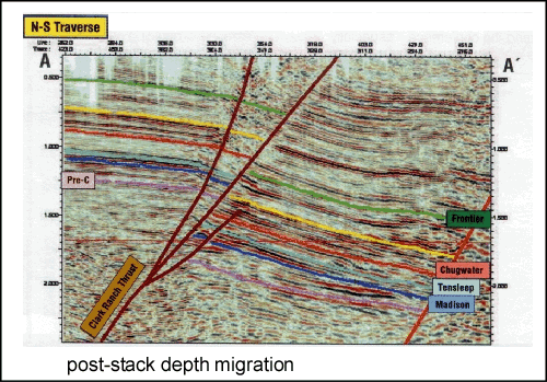
The preliminary 3-D interpretations, based on conventional time-processed data, indicated the presence of numerous anticlinal folds in subthrust positions throughout the survey. One such area was the Wyatt Draw prospect, a three-way time closure positioned along the Clark Ranch thrust, east of the main Owl Creek fault. Figure 2 shows a north-south traverse from the time-processed 3-D survey. Along the thrust, Precambrian granite is juxtaposed against shales of the Triassic Chugwater formation. Granite interval velocities in this area are as high as 19,000 feet per second, while subthrust Chugwater velocities can be as low as 12,000 feet per second. This significant lateral velocity variation severely distorts the time-migrated image below the thrust fault. To further evaluate the prospective structure, velocity analysis and depth processing of the seismic data were needed. The decision was made to utilize both pre-stack and post-stack depth migration techniques. Once the velocity field is properly accounted for, an accurate depth image of the subsurface can be achieved. Figure 3 shows the pre-stack depth migration of the same 3-D traverse as in Figure 2. There is a notable difference between the two sections, especially along the footwall portion of the Clark Ranch Thrust. By properly accounting for the high velocities associated with the granite and the Lower Paleozoic rocks in the hanging wall, the structure is now correctly imaged. Instead of having a subthrust nose lacking north dip, the Wyatt Draw prospect now as mapped has four-way closure. This closure also was evident on the post-stack depth migration, although the image was of lower quality than the pre-stack depth volume.
Based on the results of the pre-stack depth migration, a wildcat well was drilled by Cabot and Williams during the summer of 2002. The Williams #31-2 Wyatt Draw well, Section 2, T35N, R85W, Natrona Country, Wyo., was located to take advantage of the footwall structural crest for both the Tensleep Sandstone and Madison carbonate formations. Both are prolific producers in other parts of the Wind River Basin, as well as other basins in the Rockies. The well was deviated due to unfavorable surface conditions above the preferred target at depth, and drilling plans involved minimizing the amount of granite that needed to be drilled in the hanging wall. While drilling, formation tops came in very close to prognosis for both the hanging wall and footwall; these predictions were based on the pre-stack depth seismic volume combined with area well control (Figure 4). A dipmeter obtained in the well indicated the presence of critical north dip below the main thrust, and also that the bottom-hole location was near the top of the structure. A velocity check shot survey was obtained and used to create a final pre-stack depth migrated image. The crestal position of the structure moved very little, and the final depth calibration was changed by only 15 feet, confirming the quality of the original depth processing. The #31-2 Wyatt Draw wildcat was not a commercial discovery, despite finding a closed subthrust structure. Log analysis indicated marginal oil saturations and generally reduced porosities in both the Tensleep and Madison reservoirs.
Three-D seismic data, in combination with modern pre-stack depth migration techniques, can be used satisfactorily to image complexly thrusted structures, and can place a drill bit in a favorable structural location with a relatively high degree of certainty. Three-D seismic depth imaging opens the door for future exploration along basin-bounding faults in other Rockies basins.
ReferenceNatali, S.G., R. Roux, P. Dea, and F. Barrett, 2000, Cave Gulch 3-D survey, Wind River basin, Wyoming, in R.R. Ray and M.W. Longman, eds., 3-D seismic success stories in the Rocky Mountain region: The Mountain Geologist, v. 37, p. 3-13.
|

