![]() Click to view article in PDF format.
Click to view article in PDF format.
A Simple Synthesis of Caribbean Geology*
By
Keith H. James1
Search and Discovery Article #30026 (2004)
*Adapted from “extended abstract” for presentation at the AAPG International Conference, Barcelona, Spain, September 21-24, 2003.
1Consultant Geologist, 09347 Puentedura (Burgos), Spain
General Statement
This model holds that the regional plate tectonic history of the area between continental North and South America is simply one of NW-SE extension and sinistral offset.
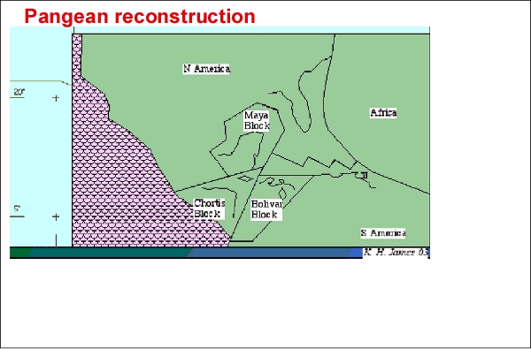
Pangean paleogeography of North and South America (Figure 1) is reconstructed by:
-
Removal of oceanic (Gulf of Mexico, Yucatan Basin, Cayman Trough and Caribbean) and island arc material (Greater, Lesser and Netherlands-Venezuelan Antilles).
-
Removal of continental/transitional crust extension (Gulf of Mexico and Venezuela margins, Florida-Bahamas platform, Nicaragua Rise).
-
Removal of sinistral offset between continental areas of North and South America and between the Maya and Chortis Blocks.
-
Restoration of northwestern South America (Bolivar Block) to the southwest.
The area evolved from this Pangean configuration, as described below and shown in Figures 2, 3, 4, 5, and 6.
|
|
PaleogeographyTriassic – Early Jurassic (Figure 2) ?Triassic-Jurassic migration of North America to the west (ca. 1000 km) and north (ca. 850 km), relative to Pangea, was accompanied by intracontinental rifting (Figure 2), extension of marginal continental crust, sinistral offset of remnant continental blocks (Maya and Chortis), and development of oceanic crust (Gulf of Mexico, Yucatan Basin, Cayman Trough, and Caribbean).
In Early Cretaceous parts of the Yucatan, Venezuelan, and Colombian basins thickened into ocean plateaus, probably because of decompression melting associated with extension over triple junctions (Figure 3). Spreading between South America and Africa resulted in connection of the Central and South Atlantic by the beginning of the Albian. Convergence between Pacific and Atlantic spreading areas and the Caribbean resulted in a newly isolated plate, bounded by subduction island-arcs (Figure 3). Throughout the Cretaceous the Mid-Atlantic Ridge lengthened, N-S, by some 650 km and stepped westward in the latitudes of 7-15 degrees N. Associated NW-SE sinistral shear in the Caribbean to the west caused NE-SW-oriented intraplate extension and plate thickening (further decompression melting) in the western Venezuelan Basin/Beata Ridge/Haitian Basin area. The Aves Ridge may have formed similarly at the same time.
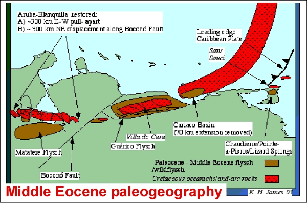
Middle Eocene (Figures 4 and 5) By Middle Eocene, island-arc activity ceased along the northern and southern Caribbean Plate boundaries. Increased clastic input reflected ocean-continent interaction, possibly triggered by the K/T impact. Violent Middle Eocene culmination of this episode, recorded by regional wildflysch deposits containing multi-kilometer olistoliths, may represent a further impact (Figure 4). Deposits include the Villa de Cura ophiolite of Venezuela and its original western extension, the Aruba-Blanquilla complex (Figure 5). A regional Middle Eocene unconformity and overlying, widespread, shallow-marine Middle Eocene carbonates record regional uplift to the photic zone, erosion, and carbonate deposition.
Since the Oligocene, the Caribbean plate has moved eastward relative to South America. Northwestern South America (Bolivar Block, Figure 2) moved northward at the same time, driven by sea-floor spreading in the Pacific. Its northernmost part transgressed the Caribbean-South America dextral plate boundary, suffering major internal pull-apart strain (Figure 6). Eastward-migrating pull-apart basins, thrust fronts, and molasse basins developed in a dextral regime along northern Venezuela/Trinidad and in a mirror-image, sinistral regime in the Greater Antilles. Extension of the Aruba-Blanquilla island chain (Figure 6, formerly obducted island-arc, Figure 5) indicates up to 300 km of eastward movement of the Caribbean relative to South and North America.
ConclusionImportant features of this model are:
|
