|
uGeneral
statement
uFigure
captions
uResults
of mapping
uPre-rift
sequences
uSyn-rift
sequences
uLarge-scale
 faulting faulting
uMeso-scale
faulting
uTectonic
evolution
uConclusion
uReferences
uGeneral
statement
uFigure
captions
uResults
of mapping
uPre-rift
sequences
uSyn-rift
sequences
uLarge-scale
faulting
uMeso-scale
faulting
uTectonic
evolution
uConclusion
uReferences
uGeneral
statement
uFigure
captions
uResults
of mapping
uPre-rift
sequences
uSyn-rift
sequences
uLarge-scale
faulting
uMeso-scale
faulting
uTectonic
evolution
uConclusion
uReferences
uGeneral
statement
uFigure
captions
uResults
of mapping
uPre-rift
sequences
uSyn-rift
sequences
uLarge-scale
faulting
uMeso-scale
faulting
uTectonic
evolution
uConclusion
uReferences
uGeneral
statement
uFigure
captions
uResults
of mapping
uPre-rift
sequences
uSyn-rift
sequences
uLarge-scale
faulting
uMeso-scale
faulting
uTectonic
evolution
uConclusion
uReferences
uGeneral
statement
uFigure
captions
uResults
of mapping
uPre-rift
sequences
uSyn-rift
sequences
uLarge-scale
faulting
uMeso-scale
faulting
uTectonic
evolution
uConclusion
uReferences
|
Figure Captions
Return to top.
The study
area includes the deeply incised north-south river valleys that transect
the southern margin of the rift around the town of Kalavrita (Figure
1). Exposures of the rift sequences have been mapped over some 500
km2 at 1:50,000 scale in an area of significant topographic
relief. Exposure in this area is variable but numerous road cuts, deeply
incised river valleys, and cliffs allow the characterisation of the main
outcrop pattern. The geological map has been used to construct
cross-sections to show the relationships identified (e.g.,
Figure 2).
In this
area, complexly deformed Mesozoic carbonate-dominated units form the
primary basement to the syn-rift fill sequences. These units were
emplaced generally from east to west across Peloponnesos during
mid-Tertiary continental collision and overthrusting (so the thrust
sheets strike perpendicular to the younger rift faults). The internal
structure of the Mesozoic units has not been mapped in this study, but
it is recognised that pre-existing structure may have played a role in
controlling, for example, the segmentation of the rift.
The
overlying ?Pliocene to Recent syn-rift fill sequences are dominantly
nonmarine, but they include the well known Gilbert-type fan delta
deposits in the northern part of the onshore rift (Ori, 1989; Dart et
al., 1994) and marine deposits of the present-day Gulf (Brooks and
Ferentinos, 1984; Stefatos et al., 2002). Many of the nonmarine
sequences are poorly dated; this means that only lithostratigraphic
correlation of units between adjacent fault blocks is currently
possible. Two major syn-rift, nonmarine, sedimentary formations above
Mesozoic basement were distinguished during the current mapping
exercise. These are critical to understanding the early evolution of the
rift. The majority of the rift deposits are south-dipping, into the
major faults.
(1)
Basal clastic fluvial/alluvial to lacustrine formation. This unit
includes basal conglomerates with massive and trough cross-stratified
pebble and cobble conglomerates which overlie the basement units. The
formation is up to ca. 800 m thick (north of the Kerpini and Dhoumena
faults). Numerous outcrops across the study area show that these
sediments are both thickened and back-rotated into the main
north-dipping faults. In addition, they strongly onlap the adjacent
hangingwall slopes (Figure 2); all of these characteristics indicate
their syn-tectonic nature. Clast compositions suggest that these early
syn-rift sediments include materials derived from the adjacent footwall
blocks, presumably during active footwall uplift and erosion.
The
southernmost depocentre, controlled by the Kalavrita Fault (Figure
2), is dominated by coarse-grained clastics supplied by the
palaeo-Vouraikos River. The lowermost conglomerates in this half-graben
are likely to be equivalent in age to the basal clastic formation, but
are lithologically indistinguishable from the subsequent progradational
formation, outlined next.
(2)
Progradational alluvial fan formation. A phase of significant
alluvial progradation subsequently transported large volumes of coarse
clastic sediment across the rift, from the south. A marked coarsening-up
facies boundary defines the base of this formation (north of the Kerpini
Fault), the deposits of which were described as braided-river and
alluvial-fan units by Doutsos and Poulimenos (1992). The main sediment
influx at this time mimics the pathway of the present day Vouraikos
River, where ca. 1.5 km of stacked, fluvial conglomerates are laterally
transitional into sands and then alluvial to lacustrine fines from south
to north. This is best observed in the Ladhopotamos River valley, which
provides an 8-km long transect through this facies change. A radial
facies-transition pattern seen to the north of the Kerpini Fault
describes a major alluvial fan. The formation can be mapped continuously
from the Kalavrita half-graben in the south, with its uninterrupted
conglomerate infill, to beyond the Mamousia-Pirghaki Fault in the north.
Thus the rift consists of one broad alluvial half-graben at this time,
>16km wide, bounded by the Kalavrita Fault in the south and with a
hangingwall extending to the north of the Mamousia-Pirghaki Fault
(Figures 2 and 3).
Return to top.
Five main
north-dipping fault systems are present in the mapped area (throws of ~2
km, average spacing of ~4 km), including the seismically active coastal
fault system, as briefly described below. A number of subsidiary faults
and splays (Figure 1) have also been identified. Where typically exposed
(bounding the footwall carbonate basement units), the fault zones dip at
40-50o at surface, although in detail they are complex
features with multiple slip planes and variable surface dips. Most
kinematic indicators suggest dip-slip movement (Roberts, 1996), but
regionally where well exposed, more complex kinematics are seen (e.g.,
parts of the coastal fault system at Alepochori in the eastern Gulf of
Corinth; RDR unpublished data, 2001).
South and
east of Kalavrita, exposures are often limited by surficial deposits but
topographic relief suggests a major W/E fault is present, defining the
southern margin of the rift. This contact corresponds to the "Khelmos
detachment fault" of Sorel (2000). The majority of the exposed rift
sediments in the Kalavrita half-graben are interpreted as part of the
progradational syn-rift package, with older syn-rift sediments exposed
along the footwall onlap surfaces, west of Kalavrita. East of the town,
exposures of carbonate suggest a further splay fault is present (Figure
1).
The next
significant fault to the north is the Kerpini Fault, which is clearly
delineated adjacent to a limestone quarry in the Vouraikos valley, 3.5
km north of Kalavrita; it can be traced several kilometres eastwards
(Figures 1 and 2).
A key observation is that, in the vicinity of the quarry, the extensive
alluvial conglomerate packages of the progradational formation are
demonstrably offset by this fault (Figure 2). Estimated maximum throw on
this fault is 2.5 km. Other smaller-offset extensional faults exposing
carbonate footwall crests are seen in the Vouraikos River valley. These
faults appear to be mostly buried beneath the progradational syn-rift
package, but locally they extend vertically to offset the lower parts of
this formation. These faults may also extend westwards and, to the east,
could link to the extension of the Kerpini Fault that occurs near
Tsivlos, where the basement outcrop makes a distinctive bend.
The
Dhoumena Fault is well-exposed (Figures 1
and 2) and has a throw in the order of 2 km.
This fault forms a distinctive topographic ridge to the west. To the
east (on the east side of the Vouraikos valley) it is interpreted to
tip-out as a monoclinal feature, where locally anomalous north-dipping
sediment panels are exposed. The basal syn-rift packages associated with
the Dhoumena Fault are well exposed in the Vouraikos River valley and to
the west. There is also excellent exposure of the onlap of the
hangingwall slope / footwall crest to the north within this half-graben
(Figures 1 and 2)
on the east side of the Vouraikos valley. At Dhoumena, the younger syn-rift,
progradational alluvial conglomerate formation is preserved as an
outlier, forming a distinctive local topographic feature adjacent to the
exposed fault plane.
To the
north, the Mamousia-Pirghaki Fault (Figures 1
and 2) is a major topographic feature,
marking the boundary between exposed nonmarine and marine/lacustrine syn-rift
deposits. The fault plane is locally exposed in the west of the study
area and in the Krathis valley in the east. The hangingwall of the fault
exposes major Gilbert-type fan deltas now, as a result of footwall
uplift related to the presently active faults (Dart et al., 1994).
The active
coastal fault system, the Eliki Fault, follows a similar trend to the
older faults. Carbonate basement is locally exposed in the footwall
crest along the coast. Modern fan delta deposits are accumulating to the
north of the Eliki fault, on the subsiding hangingwall of the present
day Gulf. The Eastern Eliki Fault trace was last ruptured by a
surface-breaking earthquake in 1861 (Schmidt, 1879). Well-defined marine
terraces exist to the south of the Eastern Eliki Fault, attesting to
uplift through the Late Pleistocene (Armijo et al., 1996; McNeill et
al., in press).
Dominantly
north-dipping planar and listric meso-scale faults are also seen in the
Vouraikos valley (throws of centimeters to ~100 m). A number of these
fault systems occur in immediate footwall (e.g., of the
Mamousia-Pirghaki Fault) or hangingwall areas (e.g., close to the
eastern tip of the Dhoumena Fault) of the larger mapped faults and are
believed to relate largely to rift-related deformation on the major
fault systems (McGurk, 1999). Where such relationships are harder to
prove, the meso-scale structures could also be related to other
mechanisms; e.g., more recent landslip events on the valley sides.
Two issues
arise: (1) the presence or absence of a regional basal detachment fault
with a fault trace >100 km long, and (2) the spatial and temporal
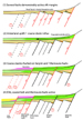
evolution of the rift and fault activity.
Firstly,
the Khelmos detachment is not mapped as a 100-km long, continuous
detachment feature. For example, the Kerpini fault is not linked
southwards to the Kalavrita fault south of Tsivlos, as was suggested by
Sorel (2000). Furthermore, the field relations described above are not
diagnostic of an underlying detachment fault. The entire system could be
described by a set of comparatively high-angled normal faults bounding
narrow half-grabens, which were back-tilted by progressive footwall
uplift. This process is clearly evident along the present-day rift
margin by the exposure, uplift, and backtilting of originally horizontal
Gilbert fan delta top-sets in the hangingwall of the Mamousia-Pirghaki
Fault. Fault planes across the region dip at ca. 40-60o at
outcrop, consistent with backtilting of successive footwall fault
blocks.
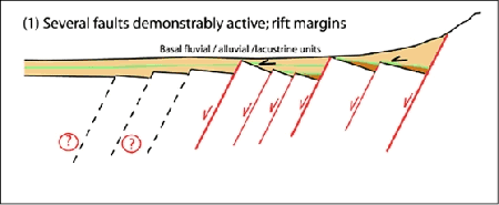
Secondly,
the timing of faulting is more complex than previously recognised (Figure
3). A relative chronology of fault activity that has been
established differs significantly in detail from that proposed by Sorel
(2000):
1) Activity
was initially distributed over a relatively wide area with three major
faults (Kalavrita, Kerpini and Dhoumena Faults) and several subsidiary
or splay faults active. It is not known if the Mamousia-Pirghaki fault
was also active at this time. Neither is it known whether antithetic
faults lay farther to the north, forming a northern margin to the rift.
2)
Subsidence on the Kalavrita Fault continued, generating accommodation
space for a significant thickness of fluvial conglomerates. Progradation
of this conglomeratic wedge then resulted in a major fluvial influx
northwards across the rift, with a significant alluvial fan developed to
the north of the Kerpini Fault. Some combination of regional hinterland
uplift, major reactivation of the Kalavrita Fault (footwall uplift), or
conversely a reduction of accommodation space in the Kalavrita
depocentre, or even climatic change may have triggered this major
progradational pulse across the rift. Some faults remained active during
the deposition of the lower parts of this progradational formation.
3)
Kilometre-scale faulting on the Kerpini Fault has post-dated
accumulation of the progradational alluvial fan formation. Some
reactivation and eastward propagation of the Dhoumena Fault also
post-dated the progradational episode.
4)
Subsequently the Mamousia-Pirghaki Fault system delimited the area of
rift subsidence, with ca. 1.5 km of deltaic sediments accommodated to
the north. Erosion of early syn-rift sediments would have occurred north
of the Mamousia-Pirghaki Fault system, in its uplifting footwall.
5) The
final stage of activity has seen the Mamoussia-Pirghaki Fault become
(relatively) inactive, with basin-margin stepping-north once again, onto
the Eliki Fault system.
This
evolution indicates that the rift did not evolve through a simple south
to north progression of fault-bounded basins, as previously suggested.
Rather, earliest rift activity was broadly distributed across a number
of faults (Step 1; Figure 3). At this time,
when the basal clastic fluvial/alluvial to lacustrine formation was
being deposited, the northern basin margin already lay to the north of
the Mamousia-Pirghaki Fault. Fault activity has subsequently focused
through time on the larger faults observed at the present. There is
irrefutable evidence that the southern margin of the Gulf of Corinth
rift has shifted northward (in relative terms) through time. Fault
activity has migrated in general terms from the Kalavrita to the Kerpini
to the Mamousia-Pirghaki into the Eliki Fault system. However, it is
unclear whether the width or the location of the actively subsiding rift
has changed significantly throughout its history. Models invoking
northward migration of successive, narrow depocentres (Sorel, 2000) can
therefore be discounted.
In
conclusion, the near continuous exposure of the early rift in numerous
river valleys offers a unique opportunity for evaluating the spatial and
temporal evolution of a rift and its associated sedimentary fill and for
use as extensional basin analogues for the hydrocarbon industry.
Armijo, R., Meyer, B. King, G.C.P., Rigo, A., and
Papanastassiou, D., 1996, Quaternary evolution of the Corinth Rift and
its implications for the Late Cenozoic evolution of the Aegean:
Geophysical Journal International, v. 126 (1), p. 11-53.
Bernard, P., and 27 co-authors, 1997, The Ms=6.2, June
15, 1995, Aigion earthquake (Greece): Evidence for low angle normal
faulting in the Corinth rift: Journal of Seismology, v. 1, p.131-150.
Brooks, M., and Ferentinos, G., 1984, Tectonics and
sedimentation in the Gulf of Corinth and the Zakynthos and Kefallinia
channels, western Greece: Tectonophysics, v. 101, p. 25-54.
Dart, C.J., Collier, R., Gawthorpe, R., Keller, J., and
Nichols, G. 1994, Sequence stratigraphy of (?)Pliocene-Quaternary syn-rift,
Gilbert-type fan deltas, northern Peloponnesos, Greece: Marine and
Petroleum Geology, v. 11, p. 545-560.
Doutsos, T., and Poulimenos, G., 1992, Geometry and
kinematics of active faults and their seismotectonic significance in the
western Corinth - Patras rift (Greece): Journal. Structural Geology, v.
14, no. 6, p. 689-699.
Jackson, J.A., Gagnepain, J., Houseman, G., King, G.C.P.,
Papadimitriou, P., Soufleris, C., and Virieux, J., 1982, Seismicity,
normal faulting , and the geomorphological development of the Gulf of
Corinth (Greece): The Corinth earthquake of February and March 1981:
Earth and Planetary Science Letters v. 57, p. 377-397. , and the geomorphological development of the Gulf of
Corinth (Greece): The Corinth earthquake of February and March 1981:
Earth and Planetary Science Letters v. 57, p. 377-397.
McGurk, A.C. 1999. The structure and growth of normal
fault zones: Unpublished PhD thesis, University of Leeds.
McNeill, L.C., Collier, R., Pantosti, D., De Martini, P.,
and D'Addezio, G., in press. Observations on the recent history of the
Eastern Eliki Fault: Geoarcheology Special Issue, Third International
Conference on Ancient Helike and Aigialeia: Archaeological Sites in
Geologically Active Regions.
Ori, G.G. 1989, Geologic history of the extensional basin
of the Gulf of Corinth (?Miocene-Pliocene), central Greece.:Geology, v.
17, p. 918-921.
Rietbrock, A., Tiberi, C., Scherbaum,. F., and Lyon-Caen,
H. 1996. Seismic slip on a low angle normal fault in the Gulf of
Corinth: Evidence from high-resolution cluster analysis of
microearthquakes: Geophysical Research Letters, v. 23, p. 1817-1820.
Roberts, G.P., 1996. Variation in fault-slip directions
along active and segmented normal fault systems: Journal Structural
Geology, 18, 835-845.
Sorel, D., 2000, A Pleistocene and still active
detachment fault and the origin of the Corinth-Patras rift, Greece.
Geology, v. 28, p. 83-86.
Stefatos, A., Papatheodorou, G., Ferentinos, G., Leeder,
M., and Collier, R. 2002, Seismic reflection imaging of active offshore
faults in the Gulf of Corinth: their seismotectonic significance: Basin
Research, v. 14, p. 487-502.
Return to top.
|
