![]() Click to view article in PDF format.
Click to view article in PDF format.
Rockies Domimate U.S. Onshore ‘Discovery’ of 1990s Giants*
By
M. Ray Thomasson1 and Fred F. Meissner2
Search and Discovery article #10048 (2003)
*Adapted for online presentation of “Rocky Mountain Giants” published in Oil and Gas Journal, v. 99.49, December 3, 2001, p. 44-47, and v. 99.50, December 10, 2001, p. 44, 46-50. This article is presented here with the kind permission of Oil and Gas Journal (OGJ), with our sincere appreciation to OGJ and to the authors.
It is extracted in part from Meissner and Thomasson, 2001, Exploration opportunities in the Greater Rock Mountain Region, U.S.A., in Downey, M.W., Threet, J.C., and Morgan, W.A., eds., Petroleum Provinces of the 21st Century: AAPG Memoir 74, p. 201-240. A modified version, from the OGJ articles, is published in HGS Bulletin, v. 45, no. 4, p. 43-50. An online version is posted on the website of the Colorado School of Mines, at: http://www.mines.edu/academic/geology/newstuff/rockymtngiants.html.
1Thomasson Partner Associates Inc., Denver, Colorado ([email protected])
2Colorado School of Mines, Golden, Colorado
Summary
As a result of new technology, the Greater Rocky Mountain Region (GRMR) has been the home to more giant fields “discovered” in the last 10 years than any other major U.S. onshore province. What’s more, it is one of only two provinces that have been growing in production during that time. Rocky Mountain and San Juan basin gas production have grown continuously (Figures 1 and 2). Note the major anticipated growth in new tight gas fields with increasing price (Figure 3).
Although recent advances in all technological aspects of exploration and exploitation have been important in this renaissance, equally important is the geologic setting in which abundant, extremely rich source rocks for both gas and oil are liberally distributed throughout underexplored provinces. The new technology is described before the presentation of features of the resulting eight probable giant fields found in the GRMR in the 1990s. These fields are in various stages of development.
The GRMR is a large, geologically heterogeneous area that contains numerous basins and uplifts. Although it contains a wide variety of structures generated at different times, those generated in the Early and Late Tertiary are commercially the most significant. Numerous oil prone and gas prone source rocks and prospective reservoirs are present, and these have contributed to the presence of a large number and variety of petroleum systems. Productive and prospective reservoirs include a spectrum of carbonates and sandstones that contain matrix porosity and permeability, as well as fracture-type and coalbed methane reservoirs.
Several investigating entities have estimated the potential for future producible hydrocarbon discoveries to be 10.4 to 15.4 billion bbl of petroleum liquids and 192 to 260 tcf of gas. Of particular significance to further exploration and development potential is a class of unconventional accumulations associated with pervasive regional hydrocarbon saturation, a general absence of movable ground water, and the presence of either abnormally high or low fluid pressures. These accumulations may be dynamic and transient in nature and commonly occur in low-permeability or fractured reservoirs associated with mature source rocks in the deeper parts of typical Rocky Mountain basins.
Petroleum systems present in the Cretaceous and Lower Tertiary section will be major contributors to future hydrocarbon production, and gas will be of particular importance because of the large number of coal measures present. Gas generated by thermal or bacterial processes is present in coal beds and nearby sandstone reservoirs. Exploration and development opportunity is present in regions associated with confirmed high generation-capacity source rocks but with little established production.
Much of the potential hydrocarbon resource remaining to be discovered and developed is characterized as representing the largest overall volume in the “resource pyramid.” The exploitation of this resource will depend heavily on the price of the product and the application of new and developing technology that will lower the cost of exploration and enable economically attractive development.
Most of the eight so-called “discoveries” of the 1990s represent hydrocarbon accumulations known through prior exploration. They had little economic significance until the development of geologic understanding, drilling, evaluation, and completion technology rendered them economically viable. These eight giants have been developed by:
1. Being “rediscovered” and exploited by new technology;
2. The merger of isolated coalbed methane deposits into giant fields; and
3. The development of central basin gas deposits and their eventual merging into giant fields.
This is an indication of the type and magnitude of remaining resource type and potential in the Rocky Mountain province.
|
|
Application of new technology has been an important element in discovering and establishing new oil and gas reserves in the GRMR. Many developments have occurred in areas where the presence of hydrocarbon saturation was known, but hydrocarbons could not be economically produced with then-existing capabilities. Considerable effort is under way to develop new concepts, techniques, and abilities in almost every category that bears on exploration, development, and production (Crow, 1996; Coalson et al, 1997). These developments have been so extensive that only a summary of those considered to be the most significant is presented here.
Constant advances have been made in understanding basic petroleum geology, both as a fundamental science applicable on a global scale and to specific regional cases. As applied to the GRMR, these include such items as structure (Barrs and Stevenson, 1981; Powers, 1982; Gans and Miller, 1983; Stone, 1993; Koeberl and Anderson, 1996), stratigraphy (Weimer, 1988; Dolson, 1994), source rock presence and maturity (Bond, 1984), and reservoir development and behavior (Weimer, 1988; Dolson, 1994; Goolsby and Longman, 1988; Coalson, 1989; Slatt, 1998a,b; McPeek et al., 1998; Kuuskraa, 1999). The latter is directly related to the development of both Cave Gulch and Jonah gas fields, discussed below, where the understanding of initial drainage of thick, stacked pay intervals is important.
The use of modern seismic acquisition and processing techniques has had a profound influence on exploration and development in recent years. Because most Rocky Mountain reservoirs have low porosity, “bright spot” phenomena have not been notably successful in directly identifying hydrocarbon accumulations. However, high frequency 2D, 2D swath, and 3D methods, coupled with an enhanced understanding of how reflection amplitude, frequency, anisotropy, interval velocity, and other attributes represent geologic conditions of structure and stratigraphy, have resulted in numerous successful discoveries. Unusual or complex structures such as overthrust areas, shear zones, and meteor impact features have been interpreted through the use of analog geologic models. Similarly, reefs, mounds, channels, and other stratigraphic features have been identified. The advances in seismic technique and interpretation will have a great impact on future exploration and development. Using some old (interval velocity studies) and new (fracture identification using anisotropy) techniques has allowed exploration for sweet spots within the basin centered gas settings. These techniques are being exploited in several Rocky Mountain basins.
The thousands of wells drilled in the GRMR have generated an extremely large amount of basic geologic and engineering data. Modern computer techniques have been and are still being developed to sort, analyze, and plot this large volume of information. This continuing development will undoubtedly aid in identifying exploration prospects and development projects.
Advances in well drilling, evaluation, and completion technology have had a significant impact in exploration and development. Horizontal wells offer great promise for exploiting reservoirs that are thin, have low permeability, are compartmentalized or fractured, or contain viscous oil. Although the chief application of horizontal drilling in the Rocky Mountain region has been in developing fractured reservoirs, opportunity exists in many other reservoir types and conditions. The largest oil field found in the last 10 years is Cedar Hills in North Dakota and its companion, East Lookout Butte in Montana. This field has been developed with horizontal drilling of an extremely thin (less than 10 ft) reservoir. Many Rocky Mountain reservoirs are substantially underpressured and have been penetrated with wells utilizing standard but overbalanced mud systems. Many of these reservoirs have undergone extensive reservoir damage that can be minimized by drilling with recently developed underbalanced mud and flow control drilling systems. Utilization of downhole motors and slim hole drilling has lowered drilling expenses and increased profits in the Denver basin and made some uneconomic reservoirs viable development targets. The development and use of formation imaging logs has aided the identification of depositional and structural features. These logs have proven especially useful in the evaluation of fractured reservoirs. Better understanding of log behavior in low resistivity, low contrast formations has led to better evaluation of potentially productive intervals in new or existing wells. Hydraulic fracturing of low permeability reservoirs in the Rocky Mountain area has produced economic production rates. Considerable progress has been made in designing less expensive and more efficient techniques, and improvements continue. Hydraulic fracture stimulation has proven successful in coalbed methane development (Ely et al., 1988). Cavity enlargement (“cavitation”) has also proven to be a viable technique for enhancing coalbed methane production (Palmer et al., 1992). The Resource PyramidMasters (1979) first proposed the concept of a resource triangle applied to an assessment of the economic viability of existing petroleum deposits. Thomasson (1982) subsequently adapted the concept, and Kuuskraa and Schmoker (1998) modified it into a resource pyramid (Figure 4). The pyramid’s apex represents a relatively small amount of oil or gas in very rich, easily found and exploited fields that have highly favorable economics. Most of the total available resource lies in the lower portion of the pyramid in leaner and less easily found and exploitable accumulations associated with poor or unprofitable economics. At any given time the ability to move downward from the apex of the pyramid depends on the price of the product and the finding and producing costs. Increasing technical capability gives the explorationist and the exploitationist the ability to discover commercial oil and gas from leaner accumulations. In the case of oil, several recent plays demonstrate the trend toward exploiting resources in the lower portion of the pyramid. Examples of this are production established from fractured reservoirs in: 1. Limestones in the Niobrara formation at Silo oil and gas field in the southeast Wyoming part of the Denver basin; 2. Shales and siltstones of the Bakken formation “Fairway Trend” in the North Dakota part of the Williston basin; 3. Shale in the Cane Creek member of the Paradox formation in the Paradox basin of eastern Utah; and 4. Siltstones, sandstones, and limestones of the Turner, Muddy, and Niobrara formations of the Powder River basin. All of these examples represent basin centered type accumulations developed in mature source rocks. Fractured reservoirs in the Bakken and Cane Creek are substantially overpressured; those in the Niobrara at Silo field are slightly underpressured. We see very significant additional opportunities for these play types in the San Juan, Uinta, Powder River, Denver, Paradox, and Williston basins and many basins of the Basin and Range Province. Part of the reason major oil companies failed in their most recent (mid-1980s) attempt to explore and exploit the Rocky Mountain region is that most of the reserves remaining to be discovered are in unconventional settings and the technology to take advantage of them had not yet been developed. For example, horizontal drilling technology has only recently been sufficiently developed to allow the extraction of hydrocarbon accumulations in fractured, thin, or compartmentalized reservoirs to be exploited commercially. With further technological advances of all kinds, an increasing volume of rock will become attractive for effective exploration and economic exploitation. The shape of the resource pyramid that depicts a large resource province (Figure 5a) clearly describes a much larger potential resource base than that shown in Figure 5b, which depicts a limited resource province. The volume to height ratio is greater in 5a and increases exponentially downward from the apex. The extremely large coalbed gas resource and the variety of basin centered or continuous type oil and gas accumulations generally associated with large but poor quality accumulations are abundant in the GRMR. This is best characterized by the middle portion of the much broader pyramid (Figure 5a). A position in the middle of the broader pyramid is highly favorable for exploiting large reserves, provided the technology for doing so is available and economic considerations are favorable. Most of the oil and gas postulated by the U.S. Geological Survey to be technically available for future exploration and exploitation is contained in the survey terms “unconventional” continuous type accumulations that occur in the middle part of the broader resource pyramid. Generally characterizing these accumulations are “tight” matrix porosity and-or fractured reservoirs, anomalous pressures, large areas of complete hydrocarbon saturation, and coalbed methane.
U.S. Rockies “Discoveries’: Analogs for the Future An assessment of the resource pyramid appropriate for the Greater Rocky Mountain Region demonstrates a basis for predicting a large amount of potentially discoverable and exploitable hydrocarbon resources. Further evidence justifying the prediction may be based on the recent history of exploration and development in the GRMR. There, as described above, probably eight “giant” fields that contain more than 100 million bbl of oil or 1 tcf of gas have been discovered (in most cases rediscovered) in the middle to late 1990s. These events occurred largely through the application of new technology. The fields are: 1. An oil field with a hydrodynamitally-tilted oil-water contact localized in a thin pay on the flank of a large regional anticline (Cedar Hills oil and gas field, Williston basin). 2. An overpressured gas field where reserves were derived from an underlying and downdip regional basin centered accumulation (Jonah field, Green River basin). 3. A field that contains thick columns of gas and condensate localized in a complex anticline hidden beneath a thrust plate (Cave Gulch field, Wind River basin). 4. A coalbed methane field that contains a mix of thermal and biogenic gas in high-volatile coal (Greater Drunkards Wash field, western Uinta basin). 5. A coalbed methane field with biogenic gas in lignite (Tongue River coals, Powder River basin). 6. Basin centered, low permeability, continuous gas sands on structure (Pinedale anticline, Green River basin). 7. A basin centered, low permeability, continuous gas sand (at Rulison, Mamm Creek, Cove Hollow, Buzzard, and Divide Creek fields, Piceance basin). 8. A shallow biogenic coalbed methane play (Raton basin). Details relating to geologic concepts and applied technology that led to the discovery or redevelopment of these fields are described in the following sections.
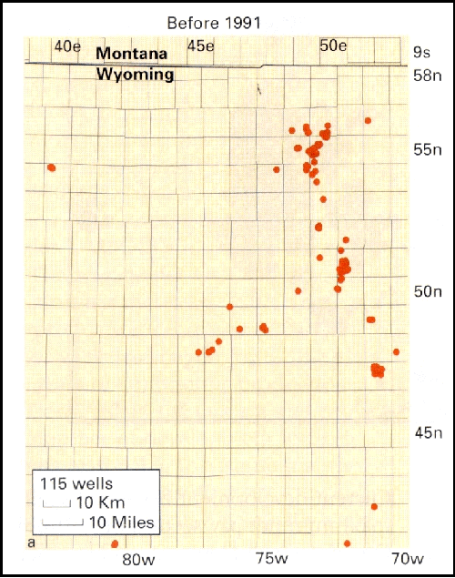
Cedar Hills Field AreaOne giant oil field has been “discovered” in the Ordovician Red River “B” Zone in the Williston basin. Cedar Hills-East Lookout Butte is a conventional reservoir but with a somewhat unconventional hydrodynamic trap. The oil at Cedar Hills-East Lookout Butte field is being exploited using the same or similar horizontal drilling technology to that applied to the unconventional fractured oil reservoirs described earlier. Here the reservoir is a thin porous interval that had previously been penetrated by several completed and abandoned oil wells that were associated with noneconomic rates of production. A porous interval (the Ordovician Red River “B” zone) is somewhat variable in thickness and extends over a large area where the oil is hydrodynamically trapped. As in all the individual cases discussed in this article, the reservoir had been drilled through and in this case had been completed noncommercially several times. The approximate outline of Cedar Hills-East Lookout Butte field at yearend 2000 (Figure 6b) had expanded dramatically due to the horizontally exploited Red River “B” zone compared with the pre-1990 boundary (Figure 6a). Some 669 horizontal wells have been drilled, resulting in 626 productive completions ranging in true vertical depth from 8,800 to 9,500 ft. Estimated ultimate recovery is now expected to exceed 130 million bbl of oil.
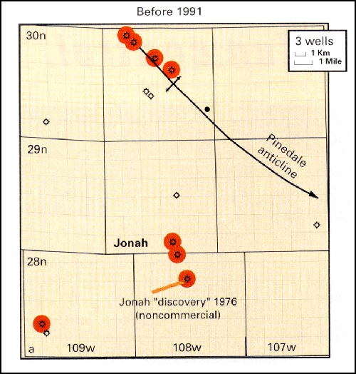
Jonah Gas FieldJonah gas field is a somewhat unique structurally controlled sweet spot within the basin centered area of the Green River basin of Wyoming. By yearend 2000 Jonah contained over 335 wells with a per well average producible reserve of between 6 and 7 bcf (Warner, 1998). Figure 7a shows the subsurface control at Jonah field in 1990 (three wells). The field was first “discovered” in 1975 by the Davis Oil Company 1 Wardell Federal, which had an initial flow rate of 303 Mcfd of gas and 2 b/d of oil. It was later rediscovered (1985) by the Home Petroleum 1-4 Jonah Federal, tested for an initial 470 Mcfd. Jonah was again rediscovered in 1993 when the McMurry Oil Company l-5 Jonah Federal tested 3.7 MMcfd and 40 b/d. The increase in production rates is attributed to improved technology in the form of better stimulation techniques. Completion technology continues to improve so that today in a pay section similar to that found in the McMurry l-5 Jonah Federal the initial rate might be 10 to 12 MMcfd. EUR averaged 2 bcf/well before 1994. Improved frac technology has raised the EUR steadily since 1992. For 1997 it was 6.76 bcf (Esphahanian et al., 1998). As noted above, the yearend 2000 configuration of the field contains 335 wells (Figure 7b). Current development has not yet established the field’s eastern limit. Jonah field has a 3,000 ft gas column. Gas is trapped laterally and updip by a set of shear zones. These shear zones allow the development of a geopressured sweet spot that is some 3,000 ft higher than the top of regional deep-basin type overpressures. There is essentially no structural displacement of the main reservoir section. The shear zones that seal the sweet spot both laterally and updip originate in the basement and have little vertical throw. However, the field itself is highly broken by faults that control anomalous overpressure displacements of as much as 600 ft in separated fault blocks within the field. This extensive internal faulting and fracturing has allowed gas to migrate vertically upward through tight rocks to a shallower reservoir, which now experiences less diagenesis and thus has higher porosity than is present in the underlying sediments associated with source rock gas generation. Current development indicates at least 2.5 tcf recoverable.
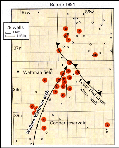
Another giant is apparent in the locations and status of wells drilled in the Cave Gulch-Waltman-Cooper Reservoir area of the Wind River basin in Wyoming before 1991 (Figure 8a). The area may ultimately contain more than 1 tcf of gas reserves added since 1990, primarily because of a different geologic concept, understood by Larry McPeek, originator of the project that led to the rediscovery and major new development. McPeek et al. (1998) recognized that even though Cave Gulch was a relatively small structural closure under the Owl Creek thrust plate, the fluvial depositional regime of the Fort Union (Lower Tertiary) and Lance (uppermost Cretaceous) formations would allow stacking of a thick package of sands containing complexly compartmentalized reservoirs and limited drainage areas, allowing tight spacing and multiple twins. For instance, in one 160 acre area 16 wells are completed. In addition, McPeek recognized the deeper sands, which had proven “noncommercial” in wells drilled before 1994, to be prospective on paleostructural highs. On these highs early gas accumulation should reduce or eliminate the diagenetic destruction of reservoir quality in deeper reservoirs. New fracturing technology has also played a significant role in successfully stimulating these deeper zones. Cave Gulch field and the resulting Waltman Trend have had some 109 shallow (3,000 to 10,000 ft) and 12 deep (17,000 to 23,000 ft) wells drilled since 1994. The yearend 2000 extent of the trend is shown in Figure 8b. Current development has established a maximum net pay section of 1,300 ft. One deep well blew out, and its calculated absolute open flow potential was 1 bcfd.
Drunkards Wash, UtahDrilling was spotty in the Greater Drunkards Wash gas area before 1991 (Figure 9a). At yearend 2000, 996 wells were producing. An aggressive drilling program is projected for the foreseeable future. Buzzards Bench coalbed methane field had one well in 1993. It now has over 110. It appears that the entire area between Drunkards Wash and Buzzards Bench fields will eventually be productive (Figure 9b). Lamarre and Burns (1999) found that the average coal thickness in Drunkards Wash field is 24 ft. One well that has been producing over 5 years from a 28 ft thick coal has cumulative production of more than 3.5 bcf and was producing 1,461 Mcfd and 369 b/d of water in 2000. The first 33 wells producing over a 65 month period averaged just under 1 MMcfd and 85 b/d of water. The average per well daily gas production has increased 380% while water production decreased 80%. None of these wells had begun to decline after 5 1/2 years of continuous production. Considering the current and projected number of development wells, it seems reasonable to assume that the Greater Drunkards Wash area, including Buzzards Bench, may eventually yield over 3 tcf.
Powder River Basin CoalsAnother coalbed methane giant gas field is being rapidly developed in the Powder River basin (Figure 10a). With more than 40 rigs running and plans for as many as 1,000 wells/year, this play is in a state of explosive development. We can be assured that this giant field developing in the Tongue River coal member of the Paleocene Fort Union Formation, which ranges from 300 to 1,200 ft in depth, will give up well over 6 tcf. Estimates with a range from as much as 7 to 25 tcf have been made Montgomery, 1999; Dea, 2001).
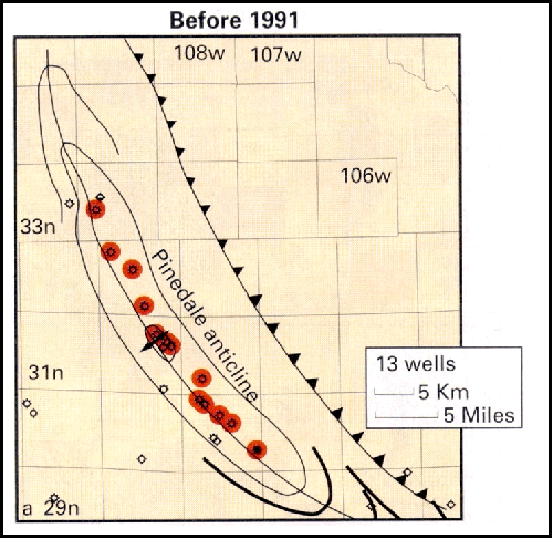
Pinedale AnticlineThis field has been a sleeping giant for many years. On an obvious giant structure, the tight gas reservoirs defeated early attempts to exploit them. Some 13 subcommercial gas and oil wells were completed before 1991. Recent drilling has demonstrated the existence of numerous sweet spots on the structure (Figure 11). The pattern is again unfolding with “discoveries” completed in the same Upper Cretaceous Lance formation productive at Jonah field. This production is now spreading along the anticline’s entire 50 mile length. Pinedale and Jonah will undoubtedly link up eventually. As Jonah has grown downdip, the two fields--one a proven giant and one a “sleeping giant”--will merge.
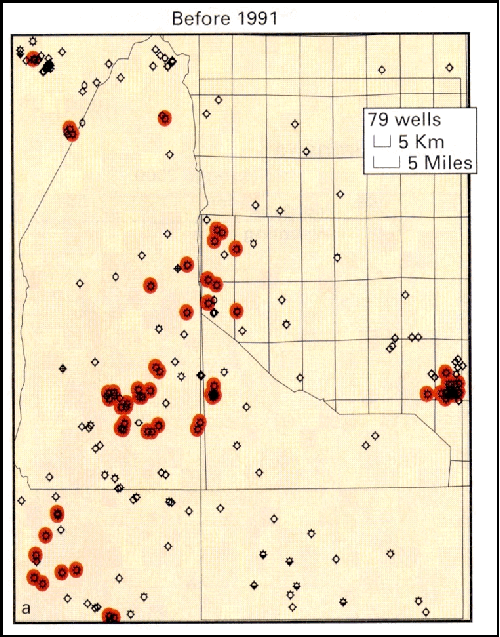
Raton Basin Coalbed GasEarly drilling in the Raton basin was unsuccessful for conventional gas reservoirs. However, in the late 1980s a few coalbed methane wells had been tried with marginal success. As new stimulation and completion technology became available in the mid-1990s, a rapid explosion took place in the development of biogenic gas in the Vermejo and Raton coals. The basin had some 79 completions at yearend 1990 (Figure 12a), and this rose to 1,135 completions and locations by yearend 2000. The Vermejo coal wells will average 1.6 bcf/well, while the Raton coals will average 1 bcf/well. The basin’s newly developing fields are growing into one giant field (Figure 12b). It is reasonable to speculate that this field will eventually yield well over 1 tcf.
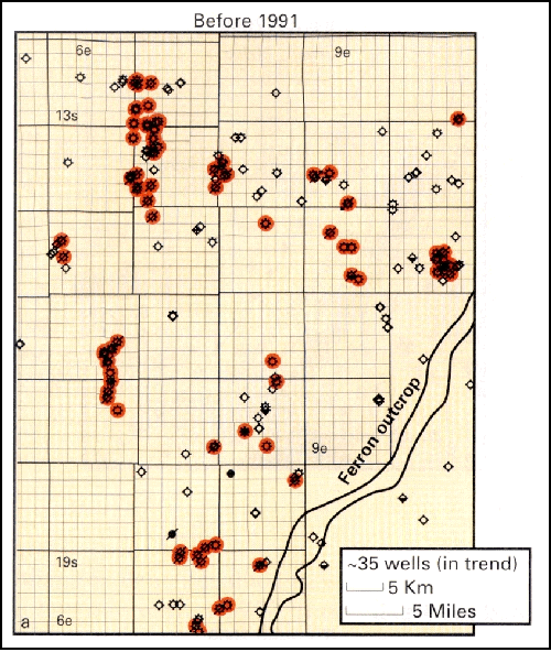
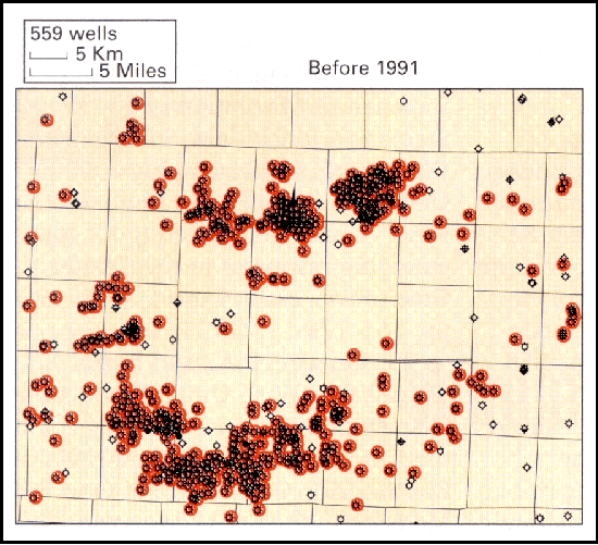
Piceance BasinThe Piceance basin has a long history of marginally economic lower volume gas wells in Lower Cretaceous formations. Drainage was initially thought to be 80 acres/well. Through time it became apparent because of the fluvial character of the reservoirs that drainage was more like 20 acres. During the past 10 years a great deal of step-out drilling and infill drilling have added significant reserves. The Rulison, Mamm Creek, Cave Hollow, Buzzard, and Divide Creek field area (Figure 13a) contained 559 wells at the end of 1990. This number had increased to 1,541 wells (Figure 13b) at yearend 2000. As these fields merge it is clear another giant is in the making, and Dea (2001) suggests several trillion cubic feet of gas will be recovered.
ReferencesBarrs, D.L., and Stevenson, G.M., 1981, Tectonic evolution of the Paradox Basin, Utah and Colorado, in Wiegand, D.L., ed., Geology of the Paradox Basin: RMAG, p. 23-31. Bond, WA., 1984, Application of Lopatin’s method to determine burial history, evolution of the geothermal gradient, and timing of hydrocarbon generation in Cretaceous source rocks in the San Juan basin, northwestern New Mexico and southwestern Colorado, in Woodward, J., Meissner, F.F., and Clayton, J.J., eds., “Hydrocarbon Source Rocks in the Greater Rocky Mountain Region: RMAG, p. 433-447. Coalson, E.B., ed., 1989, Petrogeneses and Petrophysics of Selected Sandstone Reservoirs of the Rocky Mountain Region: RMAG, 353 p. Coalson, E.B., Osmond, J.C., and Williams, E.T., eds., 1997, Innovative Applications of Petroleum Technology in the Rocky Mountain Area: RMAG, 255 p. Crow, E, 1996, U.S. independents’ technology transfer initiative mushrooming: OGJ, Aug. 19, 1996, 4 p. Dea, Peter (and Thomasson, M.R.), 2001, personal communication. Dolson, J.C., chief ed., 1994, Unconformity-related Hydrocarbons in Sedimentary Sequences--A Guidebook for Petroleum Exploration and Exploitation in Clastic and Carbonate Sediments: RMAG, 298 p. Ely, S.W, Holditch, S.A., and Carter, R.H., 1988, Improved hydraulic fracturing strategy for Fruitland Formation coal-bed methane recovery, San Juan Basin, New Mexico and Colorado, in Fassett, J.E., ed., Geology and Coal-bed Methane resources of the Northern San Juan Basin, Colorado and New Mexico: RMAG, 1988, p. 155-158. Esphahanian, C., Johnson, J., and Stabenau, J., 1998, Evolution of completion practices--Jonah field, Sublette County, Wyoming,” in Developing a Better Understanding of Basin Centered Gas Plays: Consortium meeting for the emerging resources in the Greater Green River Basin, Denver, April 1998, p. 161-179. Gans, P.B., and Miller, E.L., 1983, Style of mid-Tertiary extension in east-central Nevada: Utah Geological and Mineral Survey, Special Studies 59, p. 107-139. Goolsby, S.M., and Longman, M.W, eds., 1988, Occurrence and Petrophysical Properties of Carbonate Reservoirs in the Rocky Mountain Region: RMAG, 500 p. Koeberl, C., and Anderson, R.R., 1996, Manson and company--impact structures in the United States, in Koeberl, C., and Anderson, R.R., eds., The Manson impact structure, Iowa: Anatomy of an Impact Crater,” GSA Special Paper no. 302, p. 29. Kuuskraa, V.A., 1999, Emerging gas resources and technology,” in RMAG-PTTC-GRI, Future of Coal Bed Methane in the Rocky Mountain Region Symposium, 9 p. Lamarre, R.A., and Burns, T.D., 1999, Drunkard’s Wash Unit--Production characteristics of an expanding coalbed methane field in east-central Utah, in RMAG-PTTC-GRI, Future of Coal Bed Methane in the Rocky Mountain Region Symposium, 4 p. Kuuskraa, V.A., and Schmoker, J.W, 1998, Diverse gas plays lurk in gas resource pyramid: OGJ, June 8, 1998, p. 123-130. Masters, J.A., 1979, Deep basin gas trap, western Canada: AAPG Bulletin, v.63, p. 152-181. McPeek, L.A., Newman, G.E., and Thomasson, M.R., 1998, Cave Gulch, Wind River Basin, Wyoming, the story of a giant gas discovery: AAPG Abstracts, Annual Convention, Salt Lake City. Montgomery, S.L., 1999, Powder River Basin, Wyoming--An expanding coalbed methane (CBM) play: AAPG Bulletin, v. 83, p. 1207-1222. Palmer, I.D., Mavor, M.J., Seidle, J.P, Spitler, J.L., and Voltz, R.F., 1992, Open hole cavity completions in coalbed methane wells in the San Juan Basin: SPE Paper 24906, 67th Annual Technical Conference, Washington, DC, p. 4-7. Powers, R.B., ed., 1982, Geologic Studies of the Cordilleran Thrust Belt: RMAG, 3 v., 875 p. Slatt, R.M., ed., 1998a, Compartmentalized Reservoirs in Rocky Mountain Basins: RMAG, 250 p. Slatt, R.M., 1998b, Compartmentalized reservoirs--The exception or the rule?,” in Slatt, R.M., ed., Compartmentalized Reservoirs in Rocky Mountain Basins: RMAG, p. v-vi. Stone, D.S., 1993, Basement-involved thrust-generated folds as seismically imaged in the subsurface of the central Rocky Mountain Foreland,” in Schmidt, C.J., Chase, R.B., and Erslev, E.A., eds., Laramide Basement Deformation in the Rocky Mountain Foreland of the Western United States: GSA Special Paper no. 280. Thomasson, M.R., 1982, Synergism in exploration, in Jain, K.C., and de Figueirido, J.P., eds., Concepts and Techniques in Oil and Gas Exploration: SEG, 1982, p. 3-12. Warner, Ed (and Snyder Oil Company), 1998, personal communication. Weimer, R. J., 1988, Sequence stratigraphy--The Western Interior Cretaceous Basin: RMAG, videotape.
|
 Ray Thomasson has 44 years of technical and business experience in oil
and gas exploration. He served as head strategic planning, Shell
International (London), and planning, forecasting, and economics, Shell
U.S.; and chief geologist, Shell U.S. He is founder and owner of
Thomasson Partner Associates Inc., a private oil and gas exploration
company involved in global exploration projects. He has B.A. and M.A.
degrees from the University of Missouri and a Ph.D. degree from the
University of Wisconsin.
Ray Thomasson has 44 years of technical and business experience in oil
and gas exploration. He served as head strategic planning, Shell
International (London), and planning, forecasting, and economics, Shell
U.S.; and chief geologist, Shell U.S. He is founder and owner of
Thomasson Partner Associates Inc., a private oil and gas exploration
company involved in global exploration projects. He has B.A. and M.A.
degrees from the University of Missouri and a Ph.D. degree from the
University of Wisconsin.  Fred F. Meissner has worked extensively in the Rocky Mountains, Europe,
the South Pacific, South America, Canada, and Mexico with Shell, Sohio/BP,
and several independents. He is an adjunct professor of geology at the
Colorado School of Mines and a member of Thomasson Partner Associates
Inc. He has geological engineering and master of science degrees from
CSM and more than 40 years’ experience in oil and gas exploration.
Fred F. Meissner has worked extensively in the Rocky Mountains, Europe,
the South Pacific, South America, Canada, and Mexico with Shell, Sohio/BP,
and several independents. He is an adjunct professor of geology at the
Colorado School of Mines and a member of Thomasson Partner Associates
Inc. He has geological engineering and master of science degrees from
CSM and more than 40 years’ experience in oil and gas exploration. 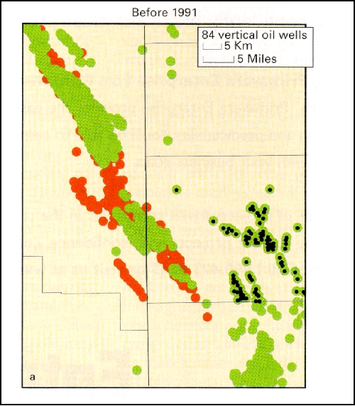