PSA Dynamic Model for the Permian Panhandle and Hugoton Fields, Western Anadarko Basin*
By
Raymond P. Sorenson1
Search and Discovery Article #20015 (2003)
*Adapted for online presentation from poster session presented at the 2003 AAPG Mid-Continent Section Meeting, Tulsa, Oklahoma, October 12-14, 2003.
1Anadarko Petroleum Corporation, Houston, TX ([email protected])
Editorial Note: This article, which is highly graphic (or visual) in design, is presented as: (1) three posters, each represented by a PDF image, which contains the usual enlargement capabilities; and (2) searchable HTML text with figure captions linked to corresponding illustrations with descriptions.
Users without high-speed internet access to this article may experience significant delay in downloading some of the PDF files due to their sizes.
Click on individual poster below, to view it in PDF format.
|
|
Abstract
Panhandle-Hugoton, the largest North American gas field, has long been controversial because of inconsistent fluid contacts, commonly attributed to hydrodynamic flow despite the absence of an updip aquifer, and extreme subnormal pressures. These anomalies are addressed in terms of a basin-scale petroleum system history, largely independent of the geographically underlying pre-Permian system.
The deep Anadarko Basin was generating hydrocarbons during Early Permian carbonate deposition, with efficient southward migration from all potential source rocks via bounding faults and Pennsylvanian-Permian alluvial fans. Giant Amarillo Uplift drape structures trapped hydrocarbons immediately following Permian evaporite deposition. The pre-Laramide Panhandle Field, at maximum pressures of 1500-2500 psi, contained most of the oil and gas now found in Midcontinent Permian reservoirs.
The Early Tertiary Laramide orogeny redistributed Panhandle Field fluid columns, possibly spilling the first gas northward into the Hugoton Embayment. Subsequent erosion of Permian reservoir facies in eastern Kansas allowed water discharge to outcrops at elevations much lower than the regional hydraulic head. As regional pressure dropped in response, the Panhandle Field gas cap expanded rapidly, forcing a Late Tertiary-Quaternary mass movement of gas northward to fill Hugoton and associated fields.
Panhandle-Hugoton reservoir pressures (435 psi at +100 feet) are normal relative to outcrop elevations of <1000 feet, negating the need for exotic theories to explain superficially subnormal conditions relative to burial depth (>2500 feet). Variations in fluid contacts, pressure, and gas composition suggest that reservoir fluids are still moving, with driving forces resulting from decompression and the rapid volumetric expansion of a supergiant gas accumulation
|
|
Anadarko Basin (Figures 1-1, 1-2, 1-3, 1-4, and 1-5)Rapid burial of numerous Anadarko Basin source rocks provided a large hydrocarbon charge during the Late Pennsylvanian-Cretaceous time period. Hydrocarbons generated in the deep Anadarko Basin followed efficient southward migration pathways, up bounding faults and “Granite Wash” alluvial fans, to the early Panhandle Field structural traps. Early Panhandle field drape structures trapped oil and gas immediately following burial of Early Permian reservoirs under Middle Permian evaporites. Panhandle -Hugoton must have been charged from pre-Permian sources, as significant Permian source rocks have not been documented within the Anadarko Basin. Pennsylvanian-Mississippian reservoirs of the Hugoton Embayment were charged by northward migration up the Anadarko Shelf. The near total absence of oil in Kansas Permian reservoirs indicates that vertical migration from underlying oil-rich Pennsylvanian and Mississippian reservoirs was not a major charge mechanism for Hugoton. Deep crustal, abiogenic, sources have been proposed for the Panhandle Field by Gold and Held (1987) and at minimum are responsible for some of the helium. Any contribution from this mechanism would have been mixed with organically-sourced hydrocarbons from the deep Anadarko Basin prior to gas cap expansion.
Panhandle-Hugoton Field (Figures 1-1 and 1-5)Panhandle-Hugoton is the largest gas field in North America, with an EUR>75 TCF, and the world’s largest source of helium. The oil rim on the northern, Anadarko Basin, side of the Panhandle Field has an EUR of 1,400 MMBO. Panhandle-Hugoton is one of the largest reservoirs in the world in terms of area (8000 square miles) and hydrocarbon pore volume (>1,000,000,000,000 barrels). Gas production in Panhandle-Hugoton, for regulatory purposes, is divided into Kansas Hugoton, Guymon (Oklahoma) Hugoton, Texas Hugoton, West Panhandle, and East Panhandle Fields. Bradshaw, Byerly, Panoma Council Grove, and other large Permian gas fields share a common genetic origin with Panhandle-Hugoton and can be considered part of the same supergiant gas accumulation. Scientific controversy has surrounded these fields because of the extreme subnormal reservoir pressures (435 psi at 2500-3000 feet) and variations in the fluid contacts and gas composition.
Panhandle-Hugoton Pressure (Figure 1-4)Panhandle-Hugoton reservoir pressures are extremely subnormal relative to burial depth, 435 psi at 2500-3000 feet. All published studies assume that Panhandle-Hugoton was originally at a normal pressure gradient, prior to the Early Tertiary Laramide orogeny. Panhandle-Hugoton is at a normal pressure gradient relative to the surface elevation of eastern Kansas reservoir outcrops. Although the distance from the Hugoton Field to the outcrop, approximately 175 miles, appears to be a long distance to expect reservoir continuity, it is actually small relative to the 275 mile length of the Panhandle-Hugoton accumulation. The regional reservoir pressure history of the Wolfcampian carbonates had a major impact on the formation of the oil and gas accumulations in the Permian of the western Anadarko Basin.
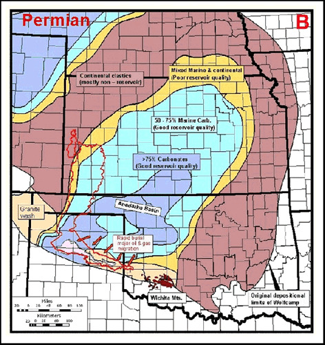
Geologic History of FieldPermian (Figure 2-1)Early Permian Wolfcampian carbonate deposition took place in an extensive embayment on the northern margin of the Permian Basin. Regionally continuous carbonate reservoirs were bounded by impermeable continental redbeds along the margins of the depositional basin. Wolfcampian strata were buried under Middle Permian Leonardian evaporites that originally covered approximately the same geographic areas and formed a regional top seal for hydrocarbon accumulation. Very early traps formed from drape structures over Amarillo Uplift – Wichita Mountain erosional topography, immediately adjacent to the axis of the Anadarko Basin. The rapid burial of the deep Anadarko Basin caused hydrocarbon generation from Woodford and other source rocks, with significant migration into the Amarillo Uplift area. By the end of the Permian, large oil and gas fields had formed in Amarillo Uplift structural traps, with normal reservoir pressure of 1000-1500 psi at 3000-4000 feet burial depths.
Cretaceous (Figure 2-2)The Anadarko Basin and Hugoton Embayment reached its maximum burial depth in the Late Cretaceous or Early Tertiary. Permian strata were regionally tilted to the west, in the direction of the Cretaceous depositional axis in the Western Interior Seaway. Hydrocarbons continued to migrate into the Amarillo Uplift area throughout the Mesozoic, with increasing gas content as Lower Paleozoic source rocks became overmature, and more gas-prone Pennsylvanian shales reached the generation window. The Panhandle Field became a supergiant structural oil and gas field, with the accumulation shifted to the east of the present-day axis because of the regional western structural tilt. With the gas compressed at a normal pressure gradient of 1500-2500 psi at 4000-6000 feet, the Panhandle Field contained most of the hydrocarbons now found in Midcontinent Permian reservoirs.
Early Tertiary (Figure 2-3)The Early Tertiary Laramide orogeny caused regional uplift and eastward tilting in the Midcontinent area. Removal of Mesozoic overburden began in the Hugoton Embayment area, and erosion of Permian strata occurred near the original depositional margin in eastern Kansas. Regional tilting redistributed fluids in the Panhandle Field, causing a general westward shift of the oil and gas accumulation and leaving residual oil saturations throughout large areas of what is now the West Panhandle gas field. The Panhandle Field maintained a normal pressure gradient of 1500-2000 psi at 4000-6000 feet, as the Wolfcampian reservoirs probably continued to be a regionally sealed container. If reservoir pressures dropped below approximately 1200-1500 psi, the Panhandle Field gas cap would have expanded to the spill point near the West Panhandle – Texas Hugoton boundary and could have leaked out to migrate north toward Kansas.
Late Tertiary (Figure 3-1)Continued erosion along the margin of the Permian depositional basin in eastern Kansas began to expose the Wolfcampian reservoir carbonates. The regional Wolfcampian aquifer system was “uncorked,” allowing water discharge at outcrop elevations much lower than the hydraulic head. As water discharged from the system in eastern Kansas, the regional aquifer pressure dropped below 1000 psi, and the decompression caused a proportionate expansion of the Panhandle Field gas volume. The Panhandle Field gas cap expanded beyond the spillpoint, flowed northward, and began to rapidly fill the Hugoton and associated gas fields. As the pressure continued to drop, the regional aquifer’s dissolved gas would have been liberated and pushed to the updip reservoir limits by the expanding gas front, providing the source of the nitrogen -rich, low-BTU gas found along the northern and western margins of Hugoton.
Quaternary (Figure 3-2)Continental glaciers reached the Permian outcrops in northeastern Kansas and, coupled with radically increased water flow in local streams and rivers, caused accelerated erosion rates and outcrop exposure for Wolfcampian reservoir carbonates. The regional Wolfcampian aquifer reached a normal hydraulic pressure gradient relative to discharge areas, at outcrops with surface elevations of 950-1000 feet. As the Panhandle- Hugoton reservoir pressure dropped to its discovery value of 435 psi at elevations of +100 feet, the gas cap continued to expand in proportion, displacing approximately 500,000,000,000 barrels of aquifer water and filling Hugoton and other field areas to their current limits. ConclusionsAccumulation of hydrocarbons in Amarillo Uplift drape structures of the Panhandle Field began during the Permian and continued throughout the Mesozoic. Primary migration was southward from the deep Anadarko Basin, up bounding faults and Permian-Pennsylvanian alluvial fans. Prior to the Early Tertiary Laramide orogeny, the Wolfcampian reservoir pressure was normal relative to burial depth (1500-2500 psi at 4000- 6000 feet). The giant structural traps of the Panhandle Field were large enough to hold, at that pressure, all of the gas now found in Midcontinent Permian reservoirs. Following Laramide uplift and tilting, erosion in eastern Kansas exposed Wolfcampian carbonates, allowing communication of the regional aquifer with the surface. Much of this erosion took place during the Quaternary, when the present outcrop belt was near the southern limit of continental glaciation. The Panhandle-Hugoton Field reservoir pressure is now controlled by aquifer discharge to outcrops of Wolfcampian reservoir carbonates in eastern Kansas, at elevations much lower than the surface elevations in the vicinity of the producing field. The discovery reservoir pressure (435 psi at +100 feet elevation) was normal relative to the outcrop discharge elevation of 950-1000 feet. The 3- to 5-fold post-Laramide drop in reservoir pressure caused a proportional increase in gas volume. The gas expanded until it crossed the structural spillpoint from the Panhandle Field, and displaced more than 500,000,000,000 barrels of water as it filled the giant stratigraphic traps of the Hugoton Embayment. Hubbert (1953, 1967) recognized the symptoms of dynamic fluid movement in the form of tilted fluid contacts and hydraulic head gradients and attributed them to west- to- east hydrodynamic water flow, despite the absence of a significant updip aquifer. The Panhandle and Hugoton Fields do in fact have a dynamic component, but the driving force is the volumetric expansion of a supergiant gas accumulation and discharge of the displaced water at the reservoir outcrop.
ReferencesDutton, Shirley P., and Chester M. Garrett, Jr., 1989, PN-13. Pennsylvanian fan-delta sandstone, Anadarko Basin: in Kosters, Elisabeth C., et al. (eds.), Atlas of Major Texas Gas Reservoirs. Gas Research Institute, Chicago, p. 146-147. Frye, John C., and A. Byron Leonard, 1952, Pleistocene Geology of Kansas. Bulletin 99, State Geological Survey of Kansas, Lawrence, 230 p. Gold, T., and M. Held, 1987, Helium-nitrogen-methane systematics in natural gases of Texas and Kansas: Journal of Petroleum Geology, vol. 10, no. 4, p. 415-424.
Hubbert, M. King, 1953,
Entrapment of petroleum under hydrodynamic conditions: AAPG Bulletin,
Hubbert, M. King, 1967, Application of hydrodynamics to oil exploration: 7th World Petroleum Congress Proceedings, Mexico City, v. 1B, p. 59-75. Johnson, Kenneth S., 1989, Geologic evolution of the Anadarko Basin: in Kenneth S. Johnson (ed.), Anadarko Basin Symposium. Circular 90, Oklahoma Geological Survey , Norman, p. 3-12. Pippin, Lloyd, 1970, Panhandle-Hugoton Field, Texas-Oklahoma-Kansas—The First Fifty Years. In Halbouty, Michel T. (ed.), Geology of Giant Petroleum Fields. AAPG Memoir 14, Tulsa, p. 204 -222.
Rascoe, Bailey, Jr., 1988, Permian System in western Midcontinent: in
Morgan, William A., and Jack A. Babcock (eds.), Permian Rocks of the
Midcontinent.Special Publication 1, Midcontinent SEPM, |
 Figure
1-1. Wolfcampian structure (after Pippin, 1970), with outline of
Panhandle-Hugoton field.
Figure
1-1. Wolfcampian structure (after Pippin, 1970), with outline of
Panhandle-Hugoton field.  Figure
1-2. Stratigraphic column (after Pippin, 1970).
Figure
1-2. Stratigraphic column (after Pippin, 1970).  Figure
1-3. South-north cross-section, Anadarko Basin (after Johnson, 1989;
Dutton and Garnett, 1989; Pippin, 1970).
Figure
1-3. South-north cross-section, Anadarko Basin (after Johnson, 1989;
Dutton and Garnett, 1989; Pippin, 1970). Figure
1-5. Upper Wolfcampian facies, (after Rascoe, 1988), with outline of
Panhandle-Hugoton field, outcrop area, and line of cross-section
Figure
1-5. Upper Wolfcampian facies, (after Rascoe, 1988), with outline of
Panhandle-Hugoton field, outcrop area, and line of cross-section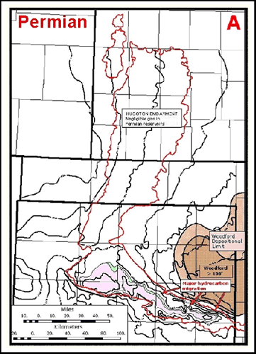