![]() Click to view poster in PDF format.
Click to view poster in PDF format.
Users may experience significant delay in downloading this file due to its size.
PSUsing Petroleum Industry 3D Surveys to Improve Understanding of Active Faults: The Palos Verdes Fault in San Pedro Bay, California*
By
Andrew W. Rigor1, Mark R. Legg2, Robert J. Mellors1, and Robert D. Francis3
Search and Discovery Article #40088 (2003)*Adapted for online presentation from award-winning poster at Student Expo, Norman, OK, March, 2003.1San Diego State University ([email protected])
2Legg Geophysical
1California State University Long Beach
AbstractLarge earthquakes
on the Palos Verdes fault may be destructive to the nearby urban areas of the
densely populated Los Angeles Basin. We interpret an industry 3D ![]() seismic
seismic![]() survey
(244 km2, CDP spacing 24.6 m inline, 50.3 m cross-line), and process
and interpret three intersecting shallow 2D profiles (16 channel, 0.95 s depth,
3.125 m CDP spacing), to map the shallow geometry (<3.0 s two-way travel time)
of the fault zone in San Pedro Bay. Several reflectors, tied to known
stratigraphic boundaries using well logs, provide timing of interpreted features
that are used to improve understanding of the fault activity and associated
survey
(244 km2, CDP spacing 24.6 m inline, 50.3 m cross-line), and process
and interpret three intersecting shallow 2D profiles (16 channel, 0.95 s depth,
3.125 m CDP spacing), to map the shallow geometry (<3.0 s two-way travel time)
of the fault zone in San Pedro Bay. Several reflectors, tied to known
stratigraphic boundaries using well logs, provide timing of interpreted features
that are used to improve understanding of the fault activity and associated
![]() seismic
seismic![]() hazard.
hazard.
We observe five
distinct fault segments in the area of the 3D survey. Each segment consists of
one primary strand that is near vertical to at least 3.0 s two-way travel time,
and one to five secondary strands forming a zone that varies from 700-2400 m
width. Several of these fault strands break latest
Quaternary sediment and are associated with bathymetrically observed deformation
at the surface. Deformation character at fault bends is consistent with a
right-slip dominated fault zone. ![]() Seismic
Seismic![]() reflections of growth and no-growth
sequences above anticlines to the west of the fault and in the Quaternary
deposits of the Wilmington graben to the east of the fault are imaged in the
2D surveys. These alternating styles in
vertical deformation may be associated with lateral movement of sedimentary
sequences along bends in the main fault strand.
reflections of growth and no-growth
sequences above anticlines to the west of the fault and in the Quaternary
deposits of the Wilmington graben to the east of the fault are imaged in the
2D surveys. These alternating styles in
vertical deformation may be associated with lateral movement of sedimentary
sequences along bends in the main fault strand.
|
|
(Complete captions accompany full-size images and follow text.)
Click here to view sequence of Figure4(a), (b), and (c).
Click here to view sequence of Figure 6(a), (b), (c), (d), and (e).
3D
2D
The Palos
Verdes fault zone has a general northwest trend (Figures
1 and 2). Bends
in the fault are associated with bathymetric changes; similarly, there
are topographic changes along the Newport-Inglewood and Whittier
faults, the other two major right-slip faults of the Los Angeles Basin..
The fault zone with its pop-up structure includes multiple fault
strands. It separates the study area into two distinct Time slices reveal a releasing bend in the southern part of the study area and a restraining bend in the center of the study area (Figures 4 and 5). The fault trend is near vertical to at least 3 s. Anticlines within the study area are the San Pedro Bay anticlinorium and the “Beta ear” anticline west of the fault (Figure 6). Also west of the fault are the toe of the Palos Verdes Hills anticlinorium (in the north) and the underlying basement ridge. East of the fault is the Wilmington “graben,” with the THUMBS –Huntington Beach fault at the northeast edge of the study area and the main Beta oilfield monocline along the restraining segment of the Palos Verdes fault. A broad anticline, perpendicular to the fault, with associated growth during the Pliocene, may indicate the initiation of right-slip motion along the fault zone (Figure 7).
The narrow,
tilted wedge of Quaternary strata southwest of the fault is generally
too shallow to be effectively imaged with the 3D data. However, lines
from 2D
3D data provided by Chevron-Texaco. Research funded by Southern California Earthquake Center.
Figure 1.
Index map. The box on the inset map shows the location of the Palos Verdes fault and study area. The polygon shows the area of the 3D
Figure 2.
Chair-cut visualization of Beta oil field 3D survey, cut at line 120, CDP 650, and time 1800 ms. Positive amplitudes are in red; negative
amplitudes, in blue. The general northwest trend of the fault zone with
its pop-up structure is visible and separates the volume into two
distinct Figure 3. A fence diagram of the locations of three 2D lines on top of the 1436-1492 ms 3D time-slice. Green vertical lines show well locations with log data. Palos Verdes fault location is superimposed with the orange wireframe, and acoustic basement is shown as a surface when color changes with depth.
Figure
4(a-c). Beta 3D
Figure 5.
The location of the segments and features of the Palos Verdes fault
through the Beta 3D survey area. Green lines indicate the locations of
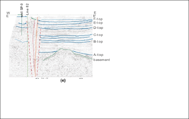
the three 16-channel Figure 6(a-e). Individual cross-sections through segments A through E are labeled A-A’ through E-E’ and shown with interpreted faults and horizons. Anticlines within this survey are the San Pedro Bay anticlinorium (SPBA) and the “Beta ear” anticline to the west of the fault. Additionally to the west of the fault is the toe of the Palos Verdes Hills anticlinorium (PVHA) in the north and the underlying basement ridge. The latter is most likely a remnant Miocene bathymetric high at the peak of a tilted crustal block due to Borderland extension and rotation. To the east of the fault is the Wilmington “graben” with the THUMBS –Huntington Beach fault at the northeast edge of the survey and the main Beta oilfield monocline along the restraining segment (c) of the Palos Verdes fault. Figure 7. A broad anticline, perpendicular to the fault, below Pliocene horizon “C-2,” with associated growth through “C-top,” may be an indicator of initiation of right-slip motion along the fault zone. Color indicates depth to horizon “C-2.” Figure 8(a-b). Close-ups of 300 ms of 2D data from (a) line 80a, above, and (b) 81, below, have been annotated to show approximate location of the Quaternary wedge of sediments overlying the Palos Verdes Hills and San Pedro Bay anticlinoria (unconformity in green), the Palos Verdes fault zone (PVF), and the Wilmington “graben.” The narrow tilted wedge of Quaternary strata lying to the southwest of the fault is generally too shallow to be effectively imaged with the 3D data; note line 80a roughly corresponds to cross-section D-D’ (Figure 6(d)). This growth wedge and the monocline to the east of the fault appear variable along strike and may be due to uplift created as sediments have been recently translated into the restraining bend. Figure 9. 2-D, E-W
|
 Figure 1.
Index map.
Figure 1.
Index map. Figure 3. A
fence diagram of the locations of three 2D lines on top of the 1436-1492
ms 3D time-slice.
Figure 3. A
fence diagram of the locations of three 2D lines on top of the 1436-1492
ms 3D time-slice. Figure 5.
The location of the segments and features of the Palos Verdes fault
through the Beta 3D survey area.
Figure 5.
The location of the segments and features of the Palos Verdes fault
through the Beta 3D survey area.  Figure
6(a-e). Individual cross-sections through segments A through E are
labeled A-A’ through E-E’ and shown with interpreted faults and horizons.
Figure
6(a-e). Individual cross-sections through segments A through E are
labeled A-A’ through E-E’ and shown with interpreted faults and horizons. Figure 7. A
broad anticline, perpendicular to the fault, below Pliocene horizon
“C-2.”
Figure 7. A
broad anticline, perpendicular to the fault, below Pliocene horizon
“C-2.” Figure
8(a-b). Close-ups of 300 ms of 2D data from (a) line 80a, above, and (b)
81, below, have been annotated to show approximate location of the
Quaternary wedge of sediments overlying anticlinoria, fault zone, and
graben.
Figure
8(a-b). Close-ups of 300 ms of 2D data from (a) line 80a, above, and (b)
81, below, have been annotated to show approximate location of the
Quaternary wedge of sediments overlying anticlinoria, fault zone, and
graben.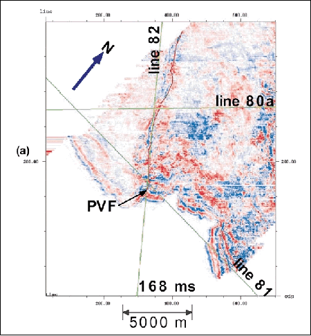