|
 Figure
1. Regional map of Chaves County, New Mexico, showing Siluro-Devonian
oil fields. Figure
1. Regional map of Chaves County, New Mexico, showing Siluro-Devonian
oil fields.
 Figure
2. 3D seismic survey location in central-eastern Chaves County, New
Mexico. Figure
2. 3D seismic survey location in central-eastern Chaves County, New
Mexico.
 Figure
3. Location of wells drilled based on 3D seismic information. Figure
3. Location of wells drilled based on 3D seismic information.
 Figure
4. Structural contour map on the top of the Mississippian unconformity,
Racetrack Complex, Chaves County, New Mexico. Figure
4. Structural contour map on the top of the Mississippian unconformity,
Racetrack Complex, Chaves County, New Mexico.
 Figure
5. Northwest to southeast seismic line (A-A’) across Racetrack Complex. Figure
5. Northwest to southeast seismic line (A-A’) across Racetrack Complex.
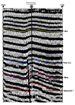 Figure
6. West to east seismic line (B-B’) across Racetrack Complex. Figure
6. West to east seismic line (B-B’) across Racetrack Complex.
 Figure
7. Structural map on top of Devonian at Chisum, Northeast Field. Figure
7. Structural map on top of Devonian at Chisum, Northeast Field.
 Table
1. 3D success rate for Siluro-Devonian wells in Chaves County, New
Mexico, as of January 1, 2002. Table
1. 3D success rate for Siluro-Devonian wells in Chaves County, New
Mexico, as of January 1, 2002.
At least 47 Siluro-Devonian tests (31 wildcats and 16 development wells)
were drilled based on the previously mentioned 3D seismic data (see
Table 1 and Figure 3). Of the 47 wells documented, 22 were completed as Siluro-Devonian oil wells, 3 were completed in zones other than the
Siluro-Devonian and 22 were plugged and abandoned.
Out of the 31 wildcats drilled, 10 were new field Siluro-Devonian
discoveries, three were new field discoveries in formations other than
the Siluro-Devonian, and 18 were dry holes. This equates to a Siluro-Devonian
wildcat success rate of 30%.
Of the 16 development wells drilled, 12 were completed as Siluro-Devonian
oil wells and 4 were plugged and abandoned, resulting in an impressive
75% development success rate. While the combined wildcat and development
success rate of 47% is a dramatic improvement over the 8% pre-3D seismic
success rate, it should be qualified in that seven of the 22 wells
completed as Siluro-Devonian oil wells will not produce at least 50,000
barrels of oil and are not considered to be a commercial success. This
brings the commercial well count down to 15 and the combined success
rate down to 32%.
It appears that reserves from the 3D wells are going to average less
than the 215 MBO per well average recovery from pre-3D wells. To date,
approximately 2.4 million barrels of oil have been recovered from the 22
wells drilled on 3D. It is estimated that the 15 commercial wells will
produce an additional 600,000 barrels of oil over their economic life
resulting in estimated recovery from the 22 3D wells of 3.0 million
barrels, for an average of 143MBO per well (only about 2/3 of the
recovery from pre-3D wells). This figure is somewhat skewed in that over
2.8 million barrels will be recovered from the 15 commercial wells (~185
MBO average for the 15 commercial wells).
It is important to note the accuracy with which the 3D identified the
structures. The 3D seismic data correctly predicted structure 75% of the
time. Seismic pitfalls, such as velocity problems, have not had a
significant impact in this play. However, in a play where structure was
once considered as the only risk, there are other risks to be
considered, such as fault seals, reservoir quality, and migration
pathways.
In at least seven of the 25 wells that were not productive in the Siluro-Devonian
structure was accurately predicted and reservoir quality rock was
encountered, but the structures were water-bearing, the apparent result
of younger faulting breaching the reservoir causing migration of oil out
of the structure.
In three of the dry holes, the structure was accurately predicted but
poor quality reservoir rock was the culprit. In two of the dry holes,
structure was accurately predicted, but the wells were drilled too low
on the feature to be productive. Faulting below the Mississippian
unconformity was identified as the culprit in two of the dry holes. In
one dry-hole structure was accurately predicted, the feature had
reservoir quality rock, and the feature did not appear to have been
influenced by younger faulting; yet the feature was not a
hydrocarbon-bearing feature. This particular feature appeared to have
been blocked from basinal hydrocarbon migration by a productive
fault-trend feature immediately downdip and basinward from the barren
feature. Most of the remaining dry holes were the result of incorrect
interpretation of the seismic data and/or poor seismic data.
In the seven Siluro-Devonian producers that look like they will be
non-economic, low relief structures and small reservoir size are the
most common causes of the low production. Using estimated seismic costs
of $5,000,000 (225 square miles x $22,500) and a rough estimate of
leasehold, drilling and completion costs of $23,000,000 (all 47 wells
included), the total cost of finding and developing (including all dry
holes) the approximately three million barrels of oil attributable to
the 3D program was around $28,000,000. The resulting combined finding
and development cost of the entire program is estimated to be $9.33 per
barrel.
Discussion: Chisum, Northeast - Racetrack Field
Three oil fields--Chisum, Northeast, Racetrack, and Racetrack,
Southeast--comprising the “Racetrack Complex,” are all located along the
same fault trend in the central portion of Chaves County. The Racetrack
Complex offers a good case study for the 3D play Siluro-Devonian play in
that the complex contains examples of 3D successes as well as offers
examples of the pitfalls that have resulted in dry holes. Within the
complex there are breached structures, tight structures, structures that
have been blocked from hydrocarbon migration and structural closures
that are located too far downdip on features to be productive.
Approximately 25 square miles of 3D seismic data has been acquired over
this area and nine wells were drilled based on interpretation of the
data. Drilling resulted in four producers and four dry holes. Production
through April 2002 from the four wells was 430 MBO and estimated
recoverable reserves should be around 770 MBO (average 193 MBO per
well).
Figure 4 is a structural contour map drawn on the top of the
Mississippian unconformity. The most obvious feature is the high-angle
reverse fault that bounds the west side of the complex. Throw on the
fault is 100-200 feet (down-to-the-west) and initial movement on the
fault was Late Mississippian to Early Pennsylvanian time with continued
flexure into Wolfcampian time. The fault “scissored” with the eastern
limb moving northward and in front of the western limb. The timing of
the scissor faulting is not clear, although it is probably younger than
Late Pennsylvanian time. This is probably the best example of “scissor”
faulting in Chaves County. The faulting apparently resulted in that
portion of the western limb in the “shadow” of the eastern limb being
blocked from hydrocarbon migration, as evidenced by the barren
structures along the southern end of the western limb. The presence of
oil-bearing structures in the structurally lower eastern limb also seems
to support hydrocarbon migration from the basin as opposed to upward
along the fault planes.
Figures 5 and 6 are seismic lines across the complex, demonstrating many
of the attributes that are common throughout the play. Productive
features are always fault-bounded (usually by down-to-the-west faults),
with varying amount of rollover into the fault. Thinning in the interval
from the Lower Pennsylvanian clastics (Atoka) to the Siluro-Devonian is
evident and supports the timing of the primary movement as Late
Mississippian to Early Pennsylvanian. Additional thinning is common in
the Permian Abo to Lower Pennsylvanian section, although it is normally
relatively minor when compared to the thinning of the deeper beds. As
seen in Figures 5 and
6, the Siluro-Devonian seismic event is often very
difficult to pick. Mapping on the Mississippian unconformity seismic
event has proven to be reliable with only a few exceptions.
Productive features found in the Racetrack Complex are low-relief
features having only 25 feet to 125 feet of closure. Area under closure
for these structures ranges from less than 40 acres to more than 300
acres; however, the productive area of these reservoirs is much less
than the area under closure. Throughout the play, the productive area is
normally only 25% to 35% of the area under closure. Why the structures
are only l/3 filled is uncertain. Thin oil columns (10-50 feet)
“sitting” on top of a very strong water drive combine to limit the
economically recoverable reserves from fields across the play.
The following is a very brief summary of the productive features found
within the
Racetrack Complex (Figures 4 and
7):
-
The White structure
(section 13-T10S-R27E) covers around 300 acres of closure with 100
feet of relief (50 feet+ oil column). Production from the two wells on
the feature has been 235 MBO (April, 2002), and recoverable reserves
are estimated to be 325 MBO.
-
The True Grit structure
(section 3-Tl l S-R28E) has approximately 160 acres under closure with
60 feet of relief (20-foot oil column). The one-well feature has
recovered 125 MBO, and recoverable reserves are estimated to be 180
MBO.
-
The Rio Bravo structure
(section 30-T10S-R28E) has approximately 120 acres under closure with
70 feet of relief (25-foot oil column). The Rio Bravo #l has flowed
115 MBO (still flowing), and recoverable oil is estimated to be 175
MBO.
-
The Rooster Cogburn
structure has 140 acres under closure with only 30 feet of relief
(10-foot oil column). The one well feature has recovered 70 MBO with
recoverable oil estimated to be only 90 MBO.
Exploration
Findings and Recommedations
The following is a brief discussion of things to look for and things to
avoid when exploring for Siluro-Devonian reservoirs in Chaves County,
New Mexico. These observations and recommendations are far from “all
encompassing” and are intended to be an aid for future exploration.
There will certainly be exceptions to almost every point
Mentioned; so “buyer beware.”
1. Look along prominent fault trends, and when possible, look along
established productive fault trends. Every productive feature that I
have seen in Chaves County is fault-bound (usually on west side), and
most are located on fault systems with established production along the
fault trend. There are several prominent fault systems in the eastern
part of the county that, to date, have yielded little to no Siluro-Devonian
oil. In addition, very little oil has been found in structures located
along minor splays off the more prominent systems.
2. Mapping the Mississippian seismic event is recommended. However, as
one moves south and east into the deeper parts of the play, where there
is a thicker Woodford Shale section, it is practical to map the Woodford
event. Beware if the Woodford structure differs significantly from the
Mississippian structure.
3. Lower Pennsylvanian (Atoka)-to-Mississippian isochron mapping has
proven to be very effective; however, it is not always easy to tie into
a reliable and continuous Lower Pennsylvanian seismic event. Abo-to-Mississippian
isochron maps should be examined on every prospect. If no thinning is
evident from the Abo to the top of the Mississippian, there probably is
not a prospect.
4. Avoid small structures. With these reservoirs only being l/3 filled,
small structures are usually uneconomic. Structures having less than 80
acres under closure generally have a productive area of less than 25
acres and recoverable oil of less than 30 MBO.
5. While these reservoirs are usually associated with low-relief
structures, it is probably wise to avoid structures having less than 50
feet of relief.
6. Use caution when dealing with structures where the faulting cuts into
the San Andres section. This becomes more common as one moves into the
northern and western parts of the county; these faults seem to be more
common on the east side of the structure. There are productive fields
associated with this type of structure, but there are numerous
structures that appear to have been breached by this type of faulting.
At a minimum, when dealing with structures affected by younger faulting,
make sure that there is good rollover into the fault(s). Rollover into
the fault is not necessary when dealing with structures unaltered by
younger faulting.
7. Where there is strong evidence of a scissor fault, avoid drilling in
the “shadow” of the basinward limb of the fault. While the jury is out
as to whether these features are sourced upward along the fault plane or
by migration from the basin (or both); the Racetrack example provides
evidence that a structure in the “shadow” can be barren.
8. Use 3D technology to explore for these reservoirs and do not wait to
acquire 3D data for development. One or two properly placed wells will
drain the vast majority of these features.
9. Try to use existing 2D seismic and/or other relatively cheap
exploration methods to establish a good reason for shooting a 3D survey.
While there have not been many large 3D surveys shot in Chaves County,
it is interesting to note that the two largest surveys shot to date have
resulted in no production.
10. Go to
Church because you’re gonna need all the help you can get.
Return
to top.
|