![]() Click
to view presentation in PDF format (with end members of flyby for quicker access).
Click
to view presentation in PDF format (with end members of flyby for quicker access).
Click to view presentation in PDF format in its entirety (slow to open due to file size).
Evolution of the Northern Gulf of Mexico Through the Cenozoic
A 3D Visualization Tour*
By
Dennis A. Sylvia1, William E. Galloway1, and Ricardo Combellas1
Search and Discovery Article #40093, (2003)
*Adaptation of ePoster presentation at AAPG Annual Convention, Salt Lake City, Utah, May, 2003.
1John A. and Katherine G. Jackson School of Geosciences, The University of Texas at Austin ([email protected]; [email protected])
Editorial Note: All data proprietary. For permission to use material, contact: Patricia E. Ganey-Curry, UT Institute for Geophysics ([email protected]).
The Gulf Basin Depositional Synthesis
project’s (Galloway, et al., 2000) interpretive GIS database has been combined
with the published MMS paleodata (planktonic marine markers) and reconstructed
paleoshorelines to produce a suite of 2-D and 3-D images that relate major
depocenter evolution to the paleostructure and paleobathymetry of the northern
Gulf of Mexico (GOM). Paleobathymetric ![]() surfaces
surfaces![]() were constructed for thirteen
time steps during the Cenozoic. The reconstructions illustrate how 3-D
visualization can be used to assess the effects that eustatic and continental
climate change, and tectonics have on the sedimentation history of the GOM
basin. Bathymetric
were constructed for thirteen
time steps during the Cenozoic. The reconstructions illustrate how 3-D
visualization can be used to assess the effects that eustatic and continental
climate change, and tectonics have on the sedimentation history of the GOM
basin. Bathymetric ![]() surfaces
surfaces![]() were modeled for each of the major Oligocene and
younger depositional episodes. Doppler maps that illustrate depositional
pattern change also were constructed. Three-dimensional visualization takes
advantage of the natural human ability to see patterns in pictures and help
uncover hidden trends in the data. The constructs can be navigated in 3-D space
and time to better understand the depositional history and focus the petroleum
explorationist’s attention on those geographic areas and stratigraphic intervals
with the greatest reservoir potential.
were modeled for each of the major Oligocene and
younger depositional episodes. Doppler maps that illustrate depositional
pattern change also were constructed. Three-dimensional visualization takes
advantage of the natural human ability to see patterns in pictures and help
uncover hidden trends in the data. The constructs can be navigated in 3-D space
and time to better understand the depositional history and focus the petroleum
explorationist’s attention on those geographic areas and stratigraphic intervals
with the greatest reservoir potential.
|
|
Construction (Figures 1, 2, 3, and 4)
Click to view sequence of versions 1x and 3x
for comparison of
A summary of the paleobathymetric construction is shown in Figure 1.
Primary Input=MMS Paleodata Set Selection of GBDS depisode paleo markers High-grade DEFAT--the listed paleo-bathymetry is qualified as definite. Ecozone interpretation (Figure 2)
Grid Construction High-graded MMS well data ~700 data points per surface (average) Pliocene best constrained (~1200 per surface average) Paleoshoreline location Shoreline at maximum transgression (SMT) “Dummy” data points (e.g., abyssal plain, Florida scarp, paleoshelf margin) Force a logical grid into areas lacking well control.
Gridding (Figure 3) Surfer8 Kriging (best expresses trends) Point (honors data @ node) Ordinary (no drift) Grid (22-30N, 84-97W; 3.5 mi2cell) Grid filter Low-pass Gaussian Remove high-frequency artifacts
Figure 4 is a paleobathymetric map generated by use of Surfer Grids from processing of high-graded MMS data. Grids files are converted to text files for export to ArcView.
2D Paleobathymetry (Figures 5 and 6)
Thirteen paleobathymetry
Cautions in paleobathymetry interpretation 1. Data Highly erratic distribution 2. Methodology Gridding algorithm, spacing, filtration 3.Interpretation Displaced environments Displaced fauna
3D Paleobathymetry (Figures 7, 8, and 9)
Click to view sequence of Miocene and Pliocene 3D paleobathymetry.
Click to view sequence of Miocene and Pliocene 2D paleobathymetry.
GBDS paleobathymetry project 13 image files Sand distribution overlay 3D Analyst extension View grid data in 3D Add GBDS thematic overlays
Doppler Maps (Figures 10 and 11)
Click here to view the above maps in sequence.
Gridded data allow application of Map Algebra, the quantitative manipulation of spatially defined variables in order to create derivative maps showing change in apparent water depth. In the generation of Paleobathymetric Difference (“Doppler”) Maps, GBDS grid data (*.txt files) are used to perform grid algebra: ArcView Spatial Analyst Extension Surfer8 Younger minus older paleobathymetric surface depth (e.g., Middle Miocene – Basal Upper Miocene)
The resultant Doppler map outlines areas of apparent shoaling and apparent deepening. GBDS geological overlays include: S.M.T. (shoreline during maximum transgression) Shelf margin Salt domains Faults Sand depocenters Fluvial axes
Interpretation of Apparent Paleobathymetry Change (Figure 12)
1. Actual shoaling or deepening Depositional Tectonic 2. Environmental displacement Shifting fluvial/deltaic depocenters 3. Resedimentation Gravity mass transport Slope failure
Finale! The Middle Miocene Gulf of Mexico Flyby
Galloway. William C., Richard T. Buffler, Patricia Ganey-Curry, 2000, Gulf of Mexico Basin Depositional Synthesis: Mapping Neogene Sediment Dispersal Patterns of the Northern Gulf Continental Margin, in Integration of Geologic Models for Understanding Risk in the Gulf of Mexico: AAPG Discovery Series No. 1 (on CD-ROM). Tipsword, H.L., F.M. Setzer, Fred L. Smith, Jr. 1966, Interpretation of Depositional Environment in Gulf Coast Petroleum Exploration from Paleoecology and Related Stratigraphy: GCAGS Transactions, v. 16, p. 119-130.
Data courtesy of sponsors of The University of Texas at Austin Gulf Basin Depositional Synthesis. They are: EnCana, ENI Petroleum, Amerada Hess, Anadarko, ConocoPhillips, Exxon Mobil, JNOC, Kerr-McGee, Marathon, Nexen, Norsk Hydro, ChevronTexaco, Total, Unocal, and Woodside Energy. |
 Figure 2. MMS marine environment
classification (after Tipsword et al., 1966).
Figure 2. MMS marine environment
classification (after Tipsword et al., 1966).  Figure 3.
3-D diagram of surface, illustrating the utilization of Surfer8 mapping
program, along with the Kriging method of interpolation and a low-pass
Gaussian filter.
Figure 3.
3-D diagram of surface, illustrating the utilization of Surfer8 mapping
program, along with the Kriging method of interpolation and a low-pass
Gaussian filter.  Figure
4. Sample map, utilizing Surfer mapping program, with comparison of
version 3x, and version 1x, to show the
Figure
4. Sample map, utilizing Surfer mapping program, with comparison of
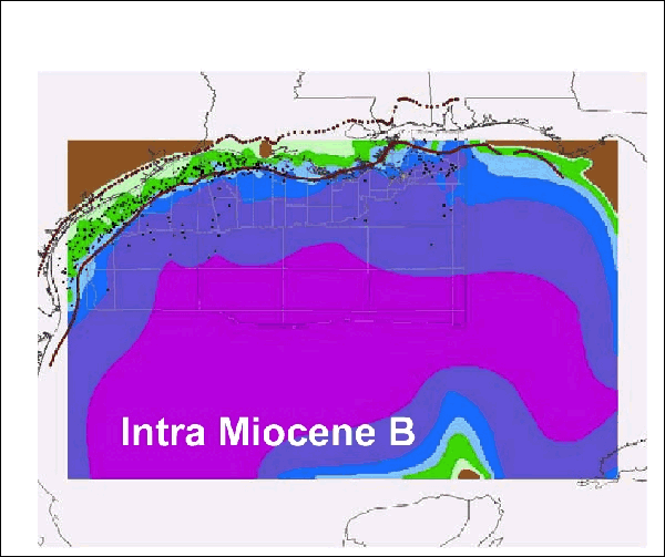
version 3x, and version 1x, to show the  Figure 5. Map, illustrating 2D
paleobathymetry of one of 13 Cenozoic
Figure 5. Map, illustrating 2D
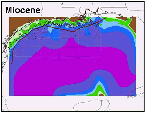
paleobathymetry of one of 13 Cenozoic  Figure 6. Miocene depositional episode,
illustrating 2D paleobathymetry. (SMT=shoreline at maximum
transgression.)
Figure 6. Miocene depositional episode,
illustrating 2D paleobathymetry. (SMT=shoreline at maximum
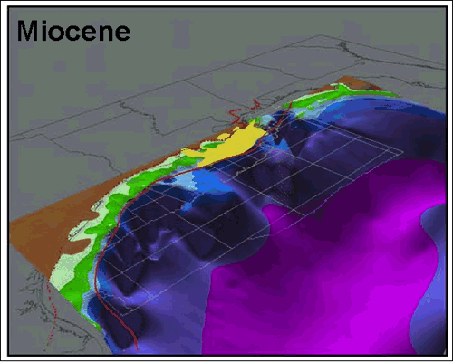
transgression.)  Figure 7. 3D Paleobathymetry for a Cenozoic
episode in the Northern Gulf of Mexico.
Figure 7. 3D Paleobathymetry for a Cenozoic
episode in the Northern Gulf of Mexico. Figure 10. An Intra Miocene Doppler map
derived as follows: Intra Miocene B - Intra-Miocene A =
Figure 10. An Intra Miocene Doppler map
derived as follows: Intra Miocene B - Intra-Miocene A =  Figure 11. The Intra Miocene Doppler map
 Figure 12. Intra-Pliocene Doppler Map derived
in the same manner as that in
Figure 12. Intra-Pliocene Doppler Map derived
in the same manner as that in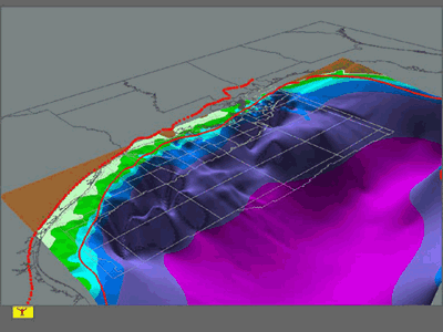 Animated Middle Miocene 3D paleobathmetry,
Gulf of Mexico.
Animated Middle Miocene 3D paleobathmetry,
Gulf of Mexico.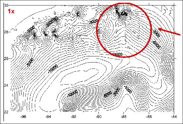