|
 Figure
1. The McGregor Range, the five tectonic elements that are present
within its boundaries (Otero platform, Hueco Mountains uplift,
Sacramento Mountains uplift, Jarilla Mountains uplift, and Tularosa
basin), and deep test wells drilled within the Range. See
Table 1 for
well data. Figure
1. The McGregor Range, the five tectonic elements that are present
within its boundaries (Otero platform, Hueco Mountains uplift,
Sacramento Mountains uplift, Jarilla Mountains uplift, and Tularosa
basin), and deep test wells drilled within the Range. See
Table 1 for
well data.
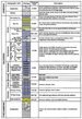 Figure
2. Stratigraphic column of rocks within McGregor Range and surrounding
areas. Figure
2. Stratigraphic column of rocks within McGregor Range and surrounding
areas.
 Figure
3. Subsurface tectonic and Permian subcrop map. Boundary of McGregor
Range is hachured. Figure
3. Subsurface tectonic and Permian subcrop map. Boundary of McGregor
Range is hachured.
 Figure
4. Cross section A-A' indicating complexity of subsurface Ancestral
Rocky Mountains structure beneath the Otero platform. See
Figure 3 for
location. Figure
4. Cross section A-A' indicating complexity of subsurface Ancestral
Rocky Mountains structure beneath the Otero platform. See
Figure 3 for
location.
 Figure
5. Summary of petroleum source rock analyses in McGregor Range and
adjacent areas. Figure
5. Summary of petroleum source rock analyses in McGregor Range and
adjacent areas.
 Figure
6. Thermal maturity of Pennsylvanian source rocks in McGregor Range and
adjacent areas. Figure
6. Thermal maturity of Pennsylvanian source rocks in McGregor Range and
adjacent areas.
 Table
1. Petroleum exploration and deep geothermal test wells drilled in the
McGregor Range. See Figure 1 for well locations. Table
1. Petroleum exploration and deep geothermal test wells drilled in the
McGregor Range. See Figure 1 for well locations.
Return
to top.
The
U.S. Army McGregor Bombing and Artillery Range is located in central and
southwestern Otero County, New Mexico (Figure 1). The McGregor Range
occupies an area of approximately 3000 km2 and is militarily
restricted. It encompasses several tectonic elements including the Otero
platform, the Hueco Mountains uplift, the Tularosa Basin, and the
Sacramento Mountains uplift.
Commercial volumes of oil and natural gas have not been discovered by
the nine wells drilled within the boundaries of the McGregor Range
(Figure 1; Table 1). The last of these wells was drilled in 1954. The
nearest discovery of commercial hydrocarbons is ten miles east of the
Range at the Heyco No. 1Y Bennett Ranch well (Figure 1) which was
drilled in 1997. The main reservoir in that well appears to be a
Tertiary age igneous sill that intruded the Mississippian section.
Exploration in this play has subsequently been extended southward into
Texas where several wells have been drilled. Nearest other production is
more than 40 miles east in the Permian Basin.
This paper is derived from a larger report prepared by the New Mexico
Bureau of Geology (formerly Mines) and Mineral Resources and TRC-Mariah
Associates, Inc. for the U.S. Army as part of the process to enable
continued use of federal lands within the McGregor Range by the U.S.
Army (New Mexico Bureau of Mines and Mineral Resources, et al., 1998).
Rocks that crop out within the boundaries of the McGregor Range are
Precambrian through Tertiary in age (Figure 2). Precambrian rocks are
basement lithologies: granite, gabbro, diabase, rhyolite porphyry, and
metasedimentary rocks. The Precambrian is exposed along the west face of
the Sacramento Mountains. Ordovician and Silurian rocks are mostly
dolostones that are present throughout the subsurface of the McGregor
Range and crop out in uplifted blocks in the Sacramento Mountains as
well as in the Texas part of the Hueco Mountains. Devonian strata are
black shales and black cherts. Mississippian strata are black shales and
thinly bedded basinal limestones. Pennsylvanian strata are present
within the extent of the late Paleozoic Orogrande Basin (Pray, 1959;
Kottlowski, 1960) but are not present on uplifted fault blocks of the
late Paleozoic Ancestral Rocky Mountains or are thin on those uplifted
blocks. Pennsylvanian limestones, shales, and sandstones crop out
extensively in the Sacramento and Hueco Mountains and on isolated
outcrops in the southern part of the McGregor Range. Permian carbonates,
shales, and sandstones blanket the area and crop out over large parts of
the Otero platform as well as the Hueco and Sacramento Mountains.
Tertiary intrusive stocks, dikes, and sills have been intersected by
several petroleum exploration wells and crop out in the Hueco, Jarilla,
Cornudas, and Sacramento Mountains. Tertiary igneous stocks form the
cores of the Hueco, Jarilla, and Cornudas Mountains.
The
McGregor Range and surrounding areas exhibit a complex interplay of
structures of late Paleozoic Ancestral Rocky Mountain age (Pennsylvanian
to Permian), Laramide age (Late Cretaceous to earliest Tertiary), and
basin-and-range (Tertiary) age. The Tularosa Basin, present along the
west side of the McGregor Range, is formed by a north-south-trending
system of downdropped fault blocks (Figure 1; King and Harder, 1985; Seager et al., 1987). Individual fault blocks are asymmetric,
west-tilted grabens related to the Tertiary-age Rio Grande rift (Mattick,
1967; Seager, 1980; Adams and Keller, 1994; Collins and Raney, 1994).
The faults that form the boundaries of the Tularosa Basin are Tertiary
in age. Tertiary and Quaternary sands and gravels fill the basin and are
thought to attain a maximum thickness of 9000 ft in the deepest parts of
the basin (Mattick, 1967; Healy et al., 1978).
The
Otero platform occupies most of the area encompassed by the McGregor
Range (Figure 1). The Otero platform is a broad, uplifted area bordered
on the west by the Tularosa Basin, on the southwest by the Hueco
Mountains uplift, on the east by the Salt Basin graben, and on the north
by the Sacramento Mountains uplift. To the south, in Texas, the Otero
platform is known as the Diablo platform.
The
most prominent structural features at the surface of the Otero platform
are en echelon systems of north to northwest trending anticlines and
synclines (Black, 1973, 1976). Axial length averages approximately 5 to
15 miles but may be as short as 5 miles and as long as 20 mi. These
folds are thought to have formed during Laramide compression in the
region but may also have seen post-Laramide movement (Black, 1973,
1976).
The
subsurface of the Otero platform is structurally more complex than the
gently folded Permian strata at the surface. For this work, subsurface
structures were interpreted from well data, regional gravity and
aeromagnetic data (Keller and Cordell, 1983; Cordell, 1983), surface
outcrop maps (Seager et al., 1987; Pray, 1961) which indicate locations
of folds and faults as well as strata1 dip at the ground surface, and
regional geophysical studies (Healy et al., 1978; Mattick, 1967).
Laramide folds and northeast-vergent Laramide thrust faults have been
superimposed upon large scale faulting of Ancestral Rocky Mountain age
(Pennsylvanian - Early Permian). The Ancestral Rocky Mountain structures
are dominated by horst and graben blocks bounded by high-angle normal
faults with northerly to northwesterly trends. These are buried beneath
Early to Middle Permian strata (Figures 3 and
4). The grabens trend
southeasterly and can be considered as southeastward extensions of the
Orogrande Basin. In the southern Sacramento Mountains, Ancestral Rocky
Mountain structures also include anticlines and synclines in which
erosionally truncated Pennsylvanian strata are overlain unconformably by
the Abo Formation (Wolfcampian; Pray, 1961).
The
age of formation of these fault blocks is constrained by distribution of
strata between the horsts and the grabens. Ordovician strata are present
in all of the grabens and on all of the horsts. Silurian, Devonian and
Mississippian strata are present in all of the grabens and on some of
the horsts. Pennsylvanian and Lower Permian strata of the Hueco Group
are present within the grabens but are not present on all of the horsts.
Where present on horst blocks, the Pennsylvanian occurs as relatively
thin erosional remnants unconformably overlain by the Pow Wow
Conglomerate (Lower Permian). The Pow Wow is correlative with the lower
tongue of the Abo Formation of the Sacramento Mountains. Elsewhere on
the horsts the Pennsylvanian was either never deposited or has been
removed by erosion and Precambrian, Ordovician, Silurian, Devonian, or
Mississippian rocks may be overlain unconformably by the Pow Wow
Conglomerate (Figure 4). Pow Wow strata thicken markedly into the
grabens, indicating syndepositional tectonic movement or perhaps
post-tectonic deposition of a molasse-type deposit into a pre-existing
structurally defined basin. Where overlain by Pennsylvanian strata, the
Mississippian section shows no discernable thickness variation across
fault boundaries and is therefore pre-tectonic. Post-Wolfcampian strata
also show no discernible thickness variations across horst and graben
boundaries and are therefore post-tectonic.
The
extensive systems of en echelon folds mapped by Black (1973, 1976) are
thought to be Laramide structures. They are concentrated over major
Ancestral Rocky Mountain fault trends and are subparallel to those fault
trends. They probably represent Laramide deformation of stratified cover
rocks during reactivation of the Ancestral Rocky Mountain faults.
A
northwest-trending reverse fault in the southwest part of the McGregor
Range (Figure 3) is well defined by U.S. Army Corps of Engineers core
holes (Table 1, wells 9 through 12). This fault offsets Paleozoic strata
from Silurian to Pennsylvanian age and is of probable Laramide age. It
is parallel to other Laramide reverse faults in southwestern New Mexico
and northern Chihuahua and represents northeast compression during the
Laramide (Mack and Clemons, 1988; Corbitt, 1988). Other reverse faults
with similar orientation may be present beneath the Recent aeolian and
alluvial sediments that cover Otero Mesa. A well-defined
northwest-southeast surface drainage pattern present at the surface may
be related to underlying structure.
The
predominant post-Laramide Tertiary structures in the region are the
normal faults that bound the Tularosa Basin and form the west face of
the Sacramento Mountains. These were formed during extensional basin and
range faulting (Healy et al., 1978; Pray, 1961). In the Jarilla and
Hueco Mountains, upward doming of Paleozoic strata by Tertiary-age
igneous stocks resulted in radial dips away from major igneous bodies.
Return
to top.
Petroleum source rocks in the region are Devonian shales and cherts,
Mississippian shales and limestones, and Pennsylvanian limestones and
shales. Petroleum source rock data (New Mexico Bureau of Mines and
Mineral Resources et al., 1998) obtained from outcrops and wells drilled
both within the grabens and on top of horst blocks indicate that other
stratigraphic units have insufficient total organic carbon (TOC) to be
considered significant source rocks or are thermally immature (Figure
5).
Devonian strata are thermally mature, oil-prone source rocks in the
McGregor Range. TOC values of the black shales range from 0.7 to 3.9
percent. Kerogens are predominantly amorphous and herbaceous types.
Although data are very limited because of a paucity of outcrops and
because few wells have drilled sufficiently deep to penetrate the
Devonian, the section appears to be mature and within the oil window
throughout most of the McGregor Range.
In
the northern part of the Range in the Sacramento Mountains (Figure l),
the Devonian is immature to marginally mature. On an uplifted fault
block in Grapevine Canyon, the Devonian is immature to marginally mature
with a Thermal Alteration Index (TAI) of only 1.5. This fault block was
interpreted by Pray (1961) to be an Ancestral Rocky Mountains structure.
It was never buried to a sufficient depth for oil generation.
In
the southern part of the McGregor Range, the Devonian is moderately
immature with a TAI of 2.0 to mature with a TAI of 3.4 at depths of 1500
ft in the U.S. Army Ft. Bliss geothermal test wells. Thermal maturity
varies vertically within a single well. Data are too limited to explain
maturity variations.
The
Devonian in the Tularosa Basin is buried to depths of more than 6500 ft
where it is very mature. TAI values are 3.8 to 3.9. These strata are in
the condensate-wet gas window and any generated petroleum that still
resides at these depths has probably been converted to condensate or wet
gas.
Mississippian strata contain thermally mature, oil-prone source rocks
throughout most of the McGregor Range and surrounding areas. TOC in both
shales and limestones is more than sufficient for petroleum generation,
ranging from 0.22 percent to 2.92 percent, exceeding 1.0 percent in most
places. In the southern part of the Range, Mississippian rocks are
mature and within the oil window with TAI values in the 2.4 to 3.1
range. In the northern part of the McGregor Range, Mississippian strata
are moderately mature with TAI values in the 2.2 to 2.5 range,
sufficient for generation of immature or heavy oils. Kerogens in
Mississippian source rocks are algal, amorphous, and herbaceous types
that will mostly generate oil and associated gas upon maturation.
Pennsylvanian strata are mature, oil-prone source rocks throughout most
of the McGregor Range. Pennsylvanian strata are mostly basinal black
lime mudstones that form good to excellent source rocks. TOC values vary
from 0.23 to 1.62 percent, more than sufficient for petroleum generation
in carbonates. Unlike older strata, sufficient data exists from
outcrops, cores, and drill cuttings to map thermal maturity patterns in
the Pennsylvanian (Figure 6). The Pennsylvanian is immature over a
northwest-trending horst block in the central part of the Range. Stratigraphic relationships reveal that the horst block is an Ancestral
Rocky Mountains structure (Figure 3). In deeper areas to the north and
south of this fault block, the basinal limestones are more mature and
within the oil window. Further to the south, maturity appears to
increase near the large Tertiary-age igneous intrusions that form the
core of the Hueco and Cornudas Mountains. It is postulated that heat
derived from the Tertiary intrusions enhanced thermal maturity of source
facies. In the Tularosa Basin to the northwest, higher temperatures
associated with deeper burial have matured the Pennsylvanian into the
condensate and gas windows.
Kerogens within the Pennsylvanian source rocks are mixed amorphous,
herbaceous, woody, and inertinitic types. Amorphous and herbaceous types
appear to be dominant in most places. Therefore, oil and associated gas
are the most likely hydrocarbons to have been generated upon maturation.
Limestones of the Hueco Group have TOC values ranging from 0.15 to 0.96
percent. However, the kerogens in many samples contain substantial
amounts of nongenerative inertinite. Generative types of kerogen are
present in insufficient amounts for significant hydrocarbon generation
and expulsion. Moreover, the Hueco is mature and within the oil window
only near intrusive igneous bodies in the Hueco Mountains and in the
deeper parts of the Tularosa Basin. The sparse data available indicate
it is immature elsewhere, even within the grabens. Therefore, it appears
that the Hueco Group is not a major source unit in the region.
Samples from Permian strata shallower than the Hueco Group were not
analyzed for source rock character. Within the McGregor Range, these
strata have either been eroded, crop out at the surface, or are not
present at any great depth within the subsurface. Post-Hueco strata
should be thermally immature because underlying strata of the Hueco
Group are thermally immature. Therefore, the role of post-Hueco strata
as source rocks in a petroleum system is inconsequential.
Return
to top.
The
main petroleum reservoir targets are Ordovician and Silurian dolostones,
Mississippian limestones, Pennsylvanian limestones, and Tertiary-age
igneous sills. Other stratigraphic units have either insufficient matrix
porosity to be considered as primary reservoir targets (unless
fractured) or crop out over large areas and are likely to have been
flushed by influent surface waters.
Dolostones of the Montoya and El Paso Groups (Ordovician) and the
Fusselman Formation (Silurian) are characterized by well-developed
vugular porosity. Several wells drilled on the Otero platform and in the
Tularosa Basin have recovered large volumes of water on drill-stem tests
or have lost circulation while drilling through the Ordovician and
Silurian dolostones, indicating good permeability is widely distributed
through this part of the section. Many but not all of the drill-stem
tests recovered fresh water, indicating that some petroleum reservoirs
may have been flushed by influent surface waters. Additional work is
required to delineate the boundaries of flushed and unflushed areas that
could conceivably be related to areas favorable to hydrodynamic
trapping. Examination of cores from the Fort Bliss geothermal evaluation
wells revealed the presence of several exposure surfaces and underlying
permeable zones characterized by karst collapse breccias within the
Fusselman.
Mississippian strata consist mostly of interbedded shales and thin,
fine-grained limestones. Although bioherms are present in the
Mississippian of the Sacramento Mountains, Greenwood et al. (1977)
concluded that most are too small to be considered major exploratory
targets. Waulsortian mounds in the Sacramento Mountains are sufficiently
large to form significant reservoirs but most were probably deposited
north of the McGregor Range in shallower water areas (W. Raatz, personal
communication, 2002). The gas discovered in the Heyco No. IY Bennett
Ranch well is produced from an interval within the Mississippian section
but the primary reservoir rock appears to be a fractured igneous sill of
Tertiary age; seals are probably Mississippian shales that also acted as
the source rocks for the gas accumulation. A similar situation exists in
the Dineh-Bi-Keyah field of Apache County, Arizona (Danie, 1978). That
field has produced oil since 1967.
Pennsylvanian strata in the Sacramento Mountains in the northern part of
the McGregor Range consist mostly of limestones and dark-gray to black
shales with minor thin sandstones. They are predominantly shelf
deposits. Bowsher (1986) documented the presence of numerous shelf and
shelf-margin bioherms that, if present in the subsurface, could be
reservoir targets.
In
the central and southern parts of the McGregor Range, the Pennsylvanian
consists primarily of basinal deposits, mostly dark-gray lime mudstones
and minor arkosic sandstones. Thin beds of carbonate grainstone were
described by Jim Witcher in core from the Fort Bliss geothermal test
wells but these form a minor facies. Soreghan and Giles (2001)
documented well-developed algal bioherms in the Panther Seep Formation
(Pennsylvanian) in the San Andres Mountains. Factors controlling
localization of algal mound growth in the Panther Seep have not been
established but are likely to include paleostructural position with
intrabasinal positive elements providing more favorable mound nucleation
sites. Other possible opportunities for reservoir development are debris
flows on the flanks of intrabasinal structures.
Pennsylvanian limestones are permeable in the McGregor Range and
adjacent areas. Exploratory wells drilled with rotary rigs have
encountered oil and gas shows and have recovered water with drill-stem
tests. Cores indicate that permeability is provided by dissolution
enhanced vertical to near-vertical fractures and not to matrix porosity.
Adams. D.C., and Keller, G.R., 1994, Crustal structure
and basin geometry in south-central New Mexico, in Keller, G.R.,
and Cather, S.M., eds., Basins of the Rio Grande rift: Structure,
stratigraphy, and tectonic setting: Geological Society of America,
Special Paper 291, p. 241-255.
Black, B.A., 1973, Geology of the northern and eastern
parts of the Otero platform, Otero and Chaves Counties, New Mexico.
Ph.D. dissertation, University of New Mexico, 158 p.
Black, B.A., 1976, Tectonics of the northern and eastern
parts of the Otero platform, Otero and Chaves Counties, New Mexico,
in Woodward, L.A., and Northrop, S.A., eds., Tectonics and mineral
resources in southwestern North America: New Mexico Geological Society,
Special Publication 6, p. 39-45.
Bowsher, A.L., 1986, Late Paleozoic reef complexes of the
northern Sacramento Mountains, New Mexico, in Ahlen, J.L., and
Hanson, M.E., eds., Southwest Section of AAPG transactions and guidebook
of 1986 convention, Ruidoso, New Mexico: New Mexico Bureau of Mines and
Mineral Resources, p. 49-72.
Collins, E.W., and Raney, J.A., 1994, Tertiary and
Quaternary tectonics of Hueco Bolson, Trans-Pecos, Texas and Chihuahua,
Mexico, in Keller, G.R., and Cather, S.M., eds., Basins of the
Rio Grande rift: Structure, stratigraphy, and tectonic setting:
Geological Society of America, Special Paper 291, p. 265-281.
Corbitt, L.L., 1988, Tectonics of thrust and fold belt of
northwestern Chihuahua: New Mexico Geological Society, Guidebook to 39th
field conference, p. 67-70.
Cordell, L., 1983, Composite residual total intensity
aeromagnetic map of New Mexico: New Mexico State University, Energy
Institute, Geothermal resources map of New Mexico, scale 1:500,000.
Danie, T.C., 1978, Dineh-Bi-Keyah (oil), in The
oil and gas fields of the Four Corners area, v. 1: Four Corners
Geological Society, p. 73-76.
Greenwood, E., Kottlowski, F.E., and Thompson, S. III,
1977, Petroleum potential and stratigraphy of Pedregosa Basin:
Comparison with Permian and Orogrande Basins: AAPG Bulletin, v. 61, p.
448-469.
Healy, D.L., Wahl, R.R., and Curray, F.E., 1978, Gravity
survey of the Tularosa valley and adjacent areas, New Mexico: U.S.
Geological Survey, Open-file report 78-309,56 p.
Keller, G.R., and Cordell, L., 1983, Bouguer gravity
anomaly map of New Mexico: New Mexico State University, Energy
Institute, Geothermal resources map of New Mexico, scale 1:500,000.
King, W.E., and Harder, V.M., 1985, Oil and gas potential
of the Tularosa Basin - Otero platform – Salt Basin graben area, New
Mexico and Texas: New Mexico Bureau of Mines and Mineral Resources,
Circular 198, 36 p.
Kottlowski, F.E., 1960, Depositional features of the
Pennsylvanian of south-central New Mexico, in Guidebook for the
northern Franklin Mountains and the southern San Andres Mountains with
emphasis on Pennsylvanian stratigraphy: Roswell Geological Society, p.
96-130.
Mack, G.H., and Clemons, R.E., 1988, Structural and
stratigraphic evidence for the Laramide (Early Tertiary) Burro uplift in
southwestern New Mexico: New Mexico Geological Society, Guidebook to 39th
field conference, p. 59-66.
Mattick, R.E., 1967, A seismic and gravity profile across
the Hueco bolson, Texas: U.S. Geological Survey, Professional Paper
575-D, p. 85-91.
New Mexico Bureau of Mines and Mineral Resources, New
Mexico State University Southwest Technology Development Institute, and
TRC Mariah Associates, Inc., 1988, Mineral and energy resource
assessment of the McGregor Range, New Mexico: Report prepared for U.S.
Army McGregor Range Renewal, Ft. Bliss Texas and New Mexico, pages not
consecutively numbered.
Pray, L.C., 1959, Stratigraphic and structural features
of the Sacramento Mountains escarpment, New Mexico, in Guidebook
of the Sacramento Mountains: Roswell Geological Society and Permian
Basin Section SEPM, p. 86- 130.
Pray, L.C., 1961, Geology of the Sacramento Mountains
escarpment, Otero County, New Mexico: New Mexico Bureau of Mines and
Mineral Resources, Bulletin 35, 144 p.
Seager, W.R., 1980, Quaternary fault system in the
Tularosa and Hueco Basins, southern New Mexico and west Texas: New
Mexico Geological Society, Guidebook to 31st field
conference, p. 131- 136.
Seager, W.R., Hawley, J.W., Kottlowski, F.E., and Kelley,
S.A., 1987, Geology of east half of Las Cruces and northeast El Paso 1o
x 2o sheets, New Mexico: New Mexico Bureau of Mines and
Mineral Resources, Geologic Map 57, scale 1:125,000.
Soreghan, G.S., and Giles, K., 2001, Depositional and
diagenetic facies in well-exposed Pennsylvanian algal mounds (western
Orogrande Basin, NM): Implications for reservoir geometry (abstract),
in Viveiros, J.J., and Ingram, S.M., eds., The Permian Basin:
microns to satellites, looking for oil and gas at all scales: West Texas
Geological Society, Publication 01-110, p. 5 1.
Work
for this project was funded by the U.S. Army via TRC-Mariah Associates
through contract DACA63-92-D-0011. Jim Witcher of New Mexico State
University kindly made available his lithologic descriptions of core
from the U.S. Army Ft. Bliss geothermal test wells. Virginia McLemore,
George Austin, Jim Barker, and Erik Munroe accompanied the author in the
field as part of the Bureau field team for the U.S. Army project. Scott
Kamber was project manager for our industrial associate, TRC-Mariah.
Steve Cather and Bill Raatz reviewed the manuscript and offered many
helpful and thoughtful suggestions.
Return
to top.
|