 |
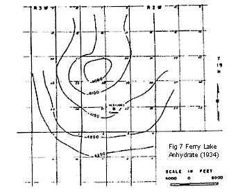
Fig. 7. ![]() Reflection
Reflection![]() seismograph map (1934) showing contours on
the base of the Ferry Lake Anhydrite. Contour interval, 50 ft.
(From Walker, 1953.)
seismograph map (1934) showing contours on
the base of the Ferry Lake Anhydrite. Contour interval, 50 ft.
(From Walker, 1953.)
Fig. 8. Surface structure on top of Minden beds compared with seismic structure on base of the Ferry Lake Anhydrite. Contour interval, 10 ft. (From Walker, 1953.)