 |
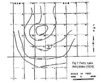
Fig. 7. Reflection seismograph map (1934) showing contours on
the base of the Ferry Lake ![]() Anhydrite
Anhydrite![]() . Contour interval, 50 ft.
(From Walker, 1953.)
. Contour interval, 50 ft.
(From Walker, 1953.)
Fig. 8. Surface structure on top of Minden beds compared with
seismic structure on base of the Ferry Lake ![]() Anhydrite
Anhydrite![]() . Contour
interval, 10 ft. (From Walker, 1953.)
. Contour
interval, 10 ft. (From Walker, 1953.)