![]() Click to view article in PDF format.
Click to view article in PDF format.
Using Detailed Gravity Surveys to Delineate Buried Glacial Scours in Northern Michigan*
Alan W. Hinks1 and Kevin J. Sullivan2
Search and Discovery Article #50204 (2009)
Posted September 17, 2009
*Adapted from extended abstract prepared for poster presentation at AAPG Annual Convention, Denver, Colorado, June 7-10, 2009
1Westshore Consulting, Muskegon, Michigan, USA ([email protected])
2Atlas Gas & Oil Company, LLC, Traverse City, Michigan, USA
The lower peninsula of Michigan is almost entirely covered by Pleistocene glacial drift which ranges in thickness from a few feet to over 1000 feet. The drift covers Paleozoic and Mesozoic bedrock. Along the northern basin margin the bedrock surface can be significantly scoured and channeled by glacial meltwaters. The northernmost natural gas production from the Upper Devonian Antrim Shale is located just south of the Antrim Shale subcrop in an area of significant bedrock scouring. Glacial scouring just south of the Antrim Shale subcrop can reduce bedrock thickness over the productive horizons in the Antrim Shale to less than State-mandated well completion requirements, or even “scour out” the Antrim Shale.
Due to both the shallowness of the bedrock (i.e., base-of-drift (BOD) surface) and the large density contrast between drift channel fill and adjacent competent bedrock, bedrock scours cause high-frequency Bouguer gravity anomalies of sufficient amplitude to be detected. Densely sampled, accurate Bouguer data is an effective way to map these features and dramatically reduce the number of “scoured-out” wells. The following discussion reviews the methodology used and results of a detailed gravity survey conducted for this purpose.
|
Gravity methods have been used in oil and gas exploration since the 1920’s. In the last several decades the instrumentation has become more accurate and easier to use. The gravity method received a significant boost in the 1980’s as Global Positioning Systems (GPS) became available making it much easier to attain the elevation accuracy required to calculate accurate Bouguer gravity data. The explorationist is usually interested in the “complete Bouguer gravity.” The complete Bouguer gravity is the portion of the gravity field caused by subsurface density contrasts. Calculation of the complete Bouguer gravity involves correcting the observed gravity for latitude and elevation variation (the “free-air gravity”) plus the mass of material above some datum (usually sea level) termed the “Bouguer correction.” Both the free-air and Bouguer corrections require precise elevation data to be accurate. A “terrain correction” is also calculated to compensate for the attraction (or deficit of attraction) caused by topography which is not at the same elevation as the meter.
The shallower a given density contrast is, the higher the frequency and amplitude of the associated anomaly. Because glacial scour features occur at relatively shallow depths and produce relief on the boundary between significantly different densities (the contact between glacial drift and bedrock), glacial scours produce gravity anomalies with relatively high frequencies and large amplitudes. In order to differentiate “scour anomalies” from deeper sourced anomalies, it is necessary to space the gravity measurements closely so that the high frequency component of the scour anomalies can be identified. In order to define the configuration of the scour features, densely sampled, accurate, and precise gravity data should be acquired.
A gravity survey is analogous to a conventional elevation survey. The survey begins at a base with gravity station measurements then taken in a loop. At the end of each loop the base is reoccupied. The collection of repeatable or precise gravity data requires that a strict methodology be followed, including use of a gravity meter capable of repeating measurements in the 10 microgal range and keeping loops short enough in duration so meter “tare” can be identified and drift can be adequately approximated via a linear function. During each loop at least one station from a previous loop is reoccupied to allow the calculation of precision. The gravity meter operator keeps track of approximate precision from a cursory comparison of repeats to original measurements to allow preliminary identification of “bad loops” and to adjust their field procedures as required.
Although precision, or repeatability, is an important indicator of gravity survey quality, methods that affect the accuracy of the data and make the survey useful instead of just an exercise in impressive precision must also be practiced. These methods include: - Placing stations away from near-zone terrain-effect sources such as ditches or abrupt changes in topography. - Mapping near zone terrain to allow calculation of accurate inner-zone terrain corrections. - Collecting elevation control within approximately ±0.1 feet. - Shortening gravity survey loops during rapid weather change to account for changes in atmospheric pressure (and therefore atmospheric density).
Gravity meters are very sensitive instruments which must be treated with care in order to obtain precise data. Since many scoured areas are undeveloped and wooded, field activities must be carefully planned to alleviate access problems which could cause unnecessary jarring of the meter. It is also important to plan out loops so that they are kept short and to make sure that gravity stations from each loop are repeated. All loops must pass QA/QC before being used. This is done by calculating the difference between the original and repeated gravity values following correction for meter drift, tides, and plate height. Any difference greater than a set value indicates that either the original loop or the repeated loop is questionable. Often the questionable loop can be ascertained by checking other repeats into that loop or field notes on conditions during the loop. In order to assure the quality of the data it is important to conduct final QA/QC while still in the field so that it remains possible to reoccupy stations as needed before any survey flagging is removed and/or access variables change.
In general, gravity surveys conducted to map the BOD surface are used to guide leasing or to delineate a scour’s boundaries prior to further drilling. A survey undertaken to guide leasing is generally conducted in phases, with data acquisition limited to public roads and unleased land (where permission is granted) first. The survey becomes more detailed as new leasing dictates. A survey conducted following the unexpected encounter of a scour is most often conducted once extensive leasing in the area has ended. Such a survey can be designed with as much detail as needed right from the start.
Once all data have passed QA/QC, the data are processed. Northern Michigan can be relatively hilly, exhibiting topographic relief in excess of 500 feet in some cases. In order for the Bouguer correction to be accurate, the density of near surface drift must be accurately estimated. Several methods exist to choose the proper Bouguer reduction density. There are mathematical methods which look for the least correlation between topography and Bouguer gravity (processed using varying densities) and graphical methods where the interpreter uses his or her judgment to accomplish the task. We have found that in Michigan the choice of the appropriate Bouguer correction density is best accomplished by graphical methods. This is because sometimes there is some correlation between topography and bedrock scours; this leads to a flawed or skewed mathematical solution. Of the graphical methods, the best known approach is the use of “Nettleton Profiles,” which are profiles showing a graph of Bouguer values calculated at several densities (which vary from unrealistically low to unrealistically high) versus topography. We believe a better method is to make what we term “Nettleton maps.” These are individual contour plots of simple residuals of Bouguer values calculated using varying reduction densities (which vary from unrealistically low to unrealistically high) overlaying a color image of topography constructed from the survey elevation control. The simple residual is usually generated as the Bouguer minus a first or second order surface of the Bouguer. Each of the Nettleton maps are plotted at a large scale (making a small image) and are set side by side in order of increasing correction density used. Existing BOD well control is also included on the maps to help determine “real” scour anomalies. From these maps an appropriate Bouguer correction density is selected. In northern Michigan Bouguer correction densities average about 1.9 g/cm3, but they can range between about 1.75 and 2.1 g/cm3. During interpretation of the Bouguer gravity it is important to consider that isolated topographic features may be composed of materials having slightly different densities than the chosen correction density. The Nettleton maps have proven a useful means to overcome this problem during interpretation of the BOD surface configuration.
Following processing, gridding, and plotting of the complete Bouguer gravity, the interpretive phase begins. The first step is to separate the high frequency anomalies associated with scours from the Bouguer gravity, which contains all frequencies captured by the survey. This is accomplished by defining the regional gravity (the lower frequency portion of the Bouguer gravity field), gridding it, and subtracting it from the Bouguer gravity grid. The resulting grid contains only high frequency anomalies and is called the “residual gravity.” Several methods can be used to define the regional gravity including grid operators which “smooth” the data, fitting the data with polynomial surfaces, and constructing a regional by hand. Review of a broadly sampled public domain gravity map allows the interpreter to gain a sense of the complexities and steepness of the regional and is helpful in determining a reasonable way to construct the regional. In Northern Michigan grid operators which smooth the data along with hand-constructed regionals have proven the most successful. Regional definition is often an iterative process utilizing frequency analyses, comparison to existing BOD well control, and gravity modeling results.
Once the initial regional grid has been constructed, it is subtracted from the Bouguer grid therein providing an initial residual. This residual Bouguer is then plotted and entered into 2-½D gravity models. Gravity models calculate the gravity response of a geologic model, in this case the BOD surface. Model profiles are located where residual anomalies are two-dimensional in nature and where well control serves to constrain the model BOD surface. The model BOD surface is then refined where not constrained by well control to best fit the residual. Lower frequency anomalies which cannot be explained by the model BOD surface indicate adjustments need to be applied to the regional. Once these adjustments are made, the regional and residual are finalized.
Next the BOD elevations from the models and well control are plotted on a residual gravity map. BOD contours are then interpreted away from the model lines, using both the residual and well control as guides. As previously mentioned, the Nettleton maps are useful during interpretation of the BOD surface. They are used to assure that an anomaly is related to BOD structure and not a topographic feature composed of material with an anomalous density. If an anomaly coincides with topography and “comes and goes” at varying reasonable reduction densities, it is probably not related to scouring. The final step in the interpretation is to construct a “cover” map. This is accomplished by gridding both the BOD surface interpretation and a map of the first productive horizon in the Antrim Shale constructed from well control. After gridding, the BOD surface grid is subtracted from the first productive horizon surface grid. The resultant grid is the bedrock cover estimate.
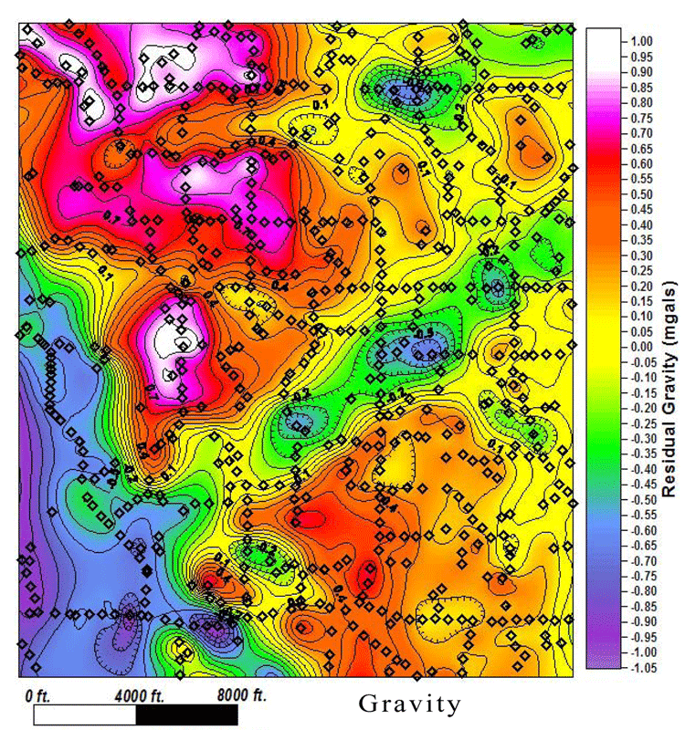
Figures 1 and 2, respectively, display the residual Bouguer gravity and interpreted BOD topography for an approximately 4 x 5 mile (6.5 x 8 km) area in northern Michigan. The depth to bedrock in the study area varies from less than 200 feet (60 m) to over 800 feet (240 m). Within the study area 73 wells have a BOD top. While this might appear to be an adequate number of wells to map BOD topography using well control only, generally, once a bedrock scour is encountered, broad areas are left underexplored.
Several linear, relatively high frequency residual lows are shown in Figure 1. They have wavelengths that are sometimes less than 0.25 miles (0.4 km) across and range in amplitude from less than 0.2 mgals to well over 1 mgal. Where adequate well control exists, it confirms a significant correlation between the linear, relatively high frequency residual lows and BOD scours. Figure 1 also demonstrates that the linear, relatively high frequency residual lows (i.e., glacial scours) often have very different trends. Figure 2 shows the associated BOD elevation interpretation that was constructed utilizing the well control, the residual, the gravity modeling results, and the Nettleton maps.
Detailed gravity surveys are an effective means to map buried glacial bedrock scours which adversely impact Antrim Shale development just south of the Antrim Shale subcrop. To be used effectively, the surveys must be detailed with the data carefully processed and interpreted.
Delineation of high frequency gravity anomalies associated with glacial scours and other bedrock topography may also be useful for other applications. Some of these applications include: - Reliable definition of lower frequency gravity anomalies in bedrock-scoured areas or areas with other significant bedrock topography. Under-sampled gravity surveys mistake high-frequency gravity anomalies (noise in this instance) for broader gravity anomalies. To properly remove the high-frequency anomalies, they must first be adequately captured. - Identification of seismic statics correction “problem” areas. During the last 6 years, detailed gravity surveys have been conducted over large areas of northern Michigan to map the BOD surface. This work has demonstrated that a large number of unsuccessful northern trend Niagaran reef exploration wells have been drilled on isolated bedrock topography, quite probably due to statics issues. Detailed gravity surveys conducted in areas with significant bedrock topography can be used to identify statics correction problems in existing seismic, as well as aid in statics corrections for newly-acquired seismic. - A greater understanding of bedrock topography may allow a clearer understanding of glacial meltwater erosion and deposition processes of the Michigan basin.
|

