Qualitative Evaluation of the Effect of Digital Field Mapping Tools on Field Mapping Workflows and 3D Spatial Cognition
J. Ryan Shackleton, Colin Dunlop, Roddy Muir, and Gareth Johnson
Midland Valley Exploration, Ltd., Glasgow, Scotland, UK
Abstract
For over a century, field geologists have been trained in paper based mapping techniques, which are advantageous in their ease of use, low cost, and versatility in a variety of field environments. Digital methods for data collection and field mapping are becoming more common as computer hardware and software components become more advanced, but how do they measure up to traditional field mapping techniques? How do they affect the data collection and 3d interpretation process? Are they worth the initial investment in hardware, software, and education? We explore these questions by describing student field mapping projects and field mapping for research purposes that have guided the development of FieldMove, a digital geologic mapping software application.
We find that digital mapping tools improve the 3D spatial interpretation process by facilitating more analysis and less data management than traditional techniques, especially in the "field office" during the evenings. When using traditional paper mapping techniques, significant time is spent on data organization, transcription from paper to digital formats, and backup of collected field data, both in the field office and after completion of the field season. Data organization and transcription may also be repeated when converting paper maps and field notes to digital formats, which is hugely inefficient and prone to errors. In the digital mapping workflow, data organization largely occurs in the field upon data collection, transcription from paper to digital format is unnecessary, and data backup can be as simple as copying digital files to external hard drives. Thus, we find that digital mapping allows more time in the evenings for problem solving, targeting areas of uncertainty, and formulating effective field plans.
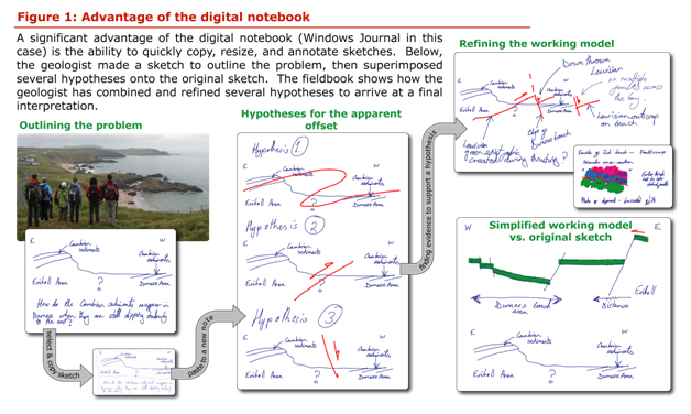
Digital field notebooks can be advantageous over paper notebooks by facilitating rapid digital communication with off-site researchers (for example in digital reports and e-mails compiled while in the field) as well as preserving thought processes in more detail. For example, the seemingly simple practice of copying and annotating a field sketch can improve the clarity of field notes by showing multiple stages of an interpretation that has been refined and tested (Fig. 1). Providing a more complete picture of the thought process used to develop an interpretation may also allow researchers to target areas of uncertainty or incompletely tested hypotheses.
We find that a common hindrance to successful digital geologic mapping is a lack of advance preparation before leaving for the field. In addition to collation of digital base maps, elevation models, and existing geologic maps, the most important aspect of preparation is practice using the software and hardware tools. As with any compass, orienteering, and basic mapping skill, advance practice ensures that the mapping device is not the focus of the user's attention, leaving the field mapper to focus on 3D spatial analysis of rock units. We find that these issues are relatively easily overcome with advance planning and training, as well as an appreciation for the potential benefits of digital field mapping.
AAPG Search and Discovery Article #120140© 2014 AAPG Hedberg Conference 3D Structural Geologic Interpretation: Earth, Mind and Machine, June 23-27, 2013, Reno, Nevada