AAPG/GSTT
HEDBERG CONFERENCE
"Mobile Shale Basins – Genesis, Evolution and Hydrocarbon
Systems"
The
Plumbing System of the Håkon Mosby Mud Volcano
–
New Insights from High-Resolution 3D seismic data
Christian Berndt,
National Oceanography Centre,
Sverre Planke,
Volcanic Basin Petroleum
Jürgen Mienert,
Stefan Bünz,
Frode Eriksen, Volcanic
Basin Petroleum
Introduction
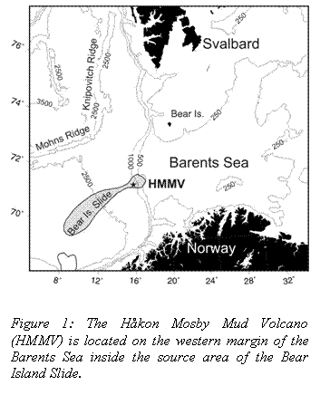
The Håkon Mosby Mud Volcano (HMMV) is located on the Barents Sea
margin on 72° N approximately halfway between the Norwegian mainland and
 The HMMV was discovered in
1989 using the SEAMARC system (Crane
et al., 1995; Vogt et al., 1991), and
soon attracted considerable attention as one of the strongest fluid flow and
heat flow anomalies on the European passive margins. Several expeditions
investigated the physical and biological properties of the system (e.g.
Eldholm et al., 1999; Vogt et al., 1999). Prominent flow features observed in side scan sonar data indicate
episodic mud eruption activity of the mud volcano (Mienert
et al., 2003). Up
to 600 m-high gas bubble flares observed in high-resolution echo sounder data
during most of the expeditions indicate almost continuous gas venting from the
seabed during the last decade. It is now widely believed that fluid, gas and
sediment mobilisation is the result of rapid loading of organic rich sediments
during the glacial interglacial cycles in the Plio- Pleistocene (Eldholm
et al., 1999; Hjelstuen et al., 1999).
The HMMV was discovered in
1989 using the SEAMARC system (Crane
et al., 1995; Vogt et al., 1991), and
soon attracted considerable attention as one of the strongest fluid flow and
heat flow anomalies on the European passive margins. Several expeditions
investigated the physical and biological properties of the system (e.g.
Eldholm et al., 1999; Vogt et al., 1999). Prominent flow features observed in side scan sonar data indicate
episodic mud eruption activity of the mud volcano (Mienert
et al., 2003). Up
to 600 m-high gas bubble flares observed in high-resolution echo sounder data
during most of the expeditions indicate almost continuous gas venting from the
seabed during the last decade. It is now widely believed that fluid, gas and
sediment mobilisation is the result of rapid loading of organic rich sediments
during the glacial interglacial cycles in the Plio- Pleistocene (Eldholm
et al., 1999; Hjelstuen et al., 1999).
Detailed investigations with manned submersibles (Mienert et al., 1999) and remote operated vehicles revealed that the HMMV is the site of a unique ecosystem that is fuelled by chemosynthesis of the gas released from the mud volcano (Damm and Budéus, 2003; Gebruk et al., 2003; Mienert et al., 2003). Therefore, this site was included in the study of ecosystem hotspots on European margin under the HERMES project. One of the first scientific expeditions within the project addressed the internal structure of the HMMV to constrain the source and the pathways, in the following called plumbing system, of gas that reaches the seabed and forms the basis for the chemosynthetic ecosystems. Here, we present initial results from the cruise, which constrain this plumbing system.
Methods and
observations
During a cruise on RV Jan Mayen of the University of Tromsø in July 2005 we collected a 3 x 7 km large 3D seismic cube comprising the HMMV and the surrounding area using the PCable system (Mienert et al., 2005; Planke and Berndt, 2002; Planke et al., 2004). The PCable collects 3D seismic data with a bandwidth from 40 to 250 Hz and with 10 m bin spacing. As it requires only single channel streamers, it can be deployed from regular research vessels although it consists of twelve streamers that are towed parallel.
In addition to the high-resolution 3D data, we acquired 3.5 kHz subbottom profiler data, EM120 multi-beam bathymetry data, five up to 4 m-long sediment cores using a gravity corer, echo sounder data, and CTD data. All data were integrated with pre-existing information including low frequency multi-channel seismic (MCS) data provided by the Norwegian Petroleum Directorate. Imaging of the HMMV depends crucially on using different seismic data types (Figure 2). As the mud volcano is a gas charged system, high frequencies are strongly attenuated resulting in 60 ms penetration for the 3.5 kHz data and some 250 ms penetration for the high-resolution 3D seismic data. Common industry MCS data with low frequencies (8-70 Hz) are less affected by free gas and image the entire sedimentary succession down to the ocean basement at 6.3 s.
The 3.5 kHz data show two prominent reflections in the central part of the mud volcano (Figure 2). They continue from the surface to approximately 80 ms beneath the seabed and are overlain by a transparent seismic unit. On the southern edge of the HMMV three closely spaced seismic reflections exist at shallow depth beneath the surface. They are pinching out southward within 800 m of the HMMV. They are underlain by another north-dipping event at 40 ms under the seabed. The high-resolution seismic data show that this event is one of several reflections that have an apex at approximately 500-1000 m away from the rim of the mud-volcano. From this apex they dip both inwards towards the centre of the mud-volcano and outwards. Here, they lap on a steeply dipping regional event that can be followed from the north of the HMMV, through an approximately 1 km interrupted area beneath the mud volcano, and to the south. This event is not clearly imaged in the MCS transect which passes the location of the other two sections approximately 300 m to the NE. The MCS data show interrupted reflectors to a depth of at least 5.3 s, where Hjelstuen et al. (1999) place the base of glacial sediments. The spatial extent of the interruption of the reflections is limited to 1-2 km.
Constraints
on the plumbing system
Assuming average seismic velocities of 2.8 km s-1 for the sedimentary successions the source of the mud-volcano is at a depth of 6 km and the sedimentary overburden is at least 4.5 km thick corresponding to 60 MPa hydrostatic pressure. The significant bubble flares in the water column indicate that gas is produced in great quantities. If the gas is rising all the way from the base of the disturbance zone, it is likely that pore pressures are significantly higher than hydrostatic pressure, because of the much greater density difference of the buried sediments and the gas than for gas that is contained in shallow sediments. Such overpressures will reduce the effective stress and facilitate subsurface sediment, fluid and gas mobilization through increased fracturing. It is perceivable that the Paleogene sediments in the HMMV region are of similar composition as the Paleogene successions on the mid-Norwegian margin. In this case loading by denser glacial sediments would result in a similar density inversion as observed under the Vema Dome where Paleogene sediments were mobilised (Hovland et al., 1998). However, as the glacial overburden is much thicker in the HMMV area (Hjelstuen et al., 1999), the area of rising sediments becomes more focused.
The preliminary evaluation of the MCS data and the high-resolution seismic data did not reveal evidence for mud chambers, i.e. mud reservoirs between the source and eruption depth. In fact, the seismic disturbance zone under the mud volcano is confined to a width of 1-2 km. This makes the HMMV different from the mud volcanoes in the Caspian Sea (Davies and Stewart, 2005; Planke et al., 2003). Possibly this is caused by the rather homogeneous glacial unit which - once penetrated- inhibits the formation of mud chambers. The regional reflection in Figure 2b seems to be penetrated by the mud volcano and is a
|
|
Figure 2: Seismic examples for the Håkon Mosby Mud Volcano (HMMV) for different seismic data sources. As a result of free gas attenuating high frequencies only a combination of seismic data types allows a meaningful structural interpretation. Bold boxes indicate the area shown in the corresponding figure above. Dashed black lines are interpreted boundaries for the base of glacial sediments (top) and top Eocene (bottom). Stratigraphic interpretations after Hjelstuen et al., 1999. |
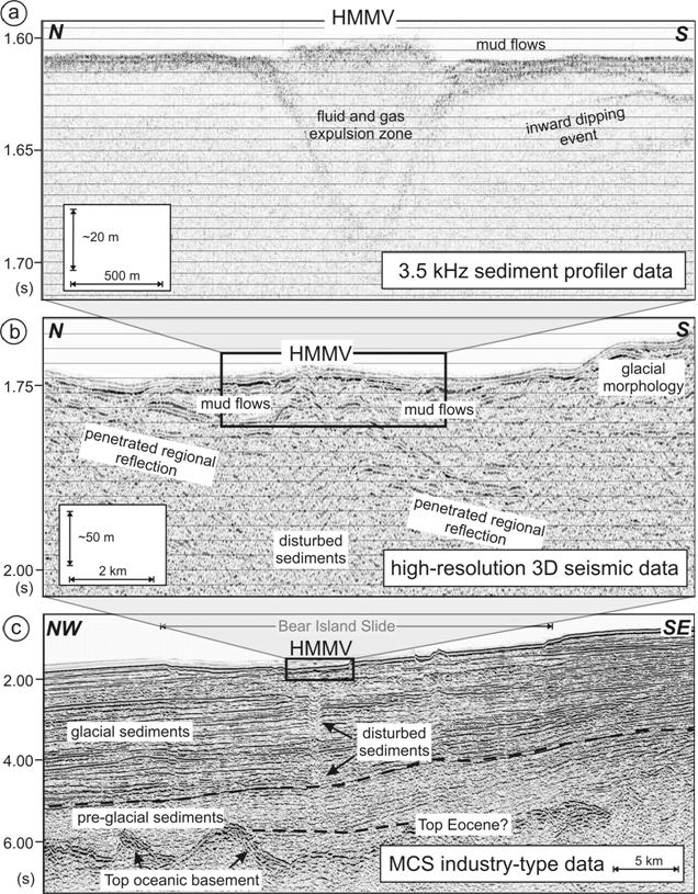
significant increase in acoustic impedance. Therefore, it might represent the base of the mud flows. It reaches a maximum depth of 150-200 m approximately 4 km south of the mud volcano (Figure 2). The longest mud flows observed both in the recently acquired seismic data and previously collected high-resolution sidescan sonar data (Mienert et al., 2003) are 2-3 km long. Assuming that the preliminary interpretation of the dipping event as the base of mud flows is correct, this implies that the total volume of mud erupted during post-glacial times is less than 1.2 km3. This is small compared to the mud volcanoes in the Caspian Sea area, e.g. 22.5 km3 for the south-easternmost mud volcano on the Aspheron Anticline (Davies and Stewart, 2005).
From (1) the observation of a deep source, (2) the lack of evidence for intermediate mud-chambers, (3) the relatively small volume of erupted mud at the surface, and (4) the prominent gas flares in the water column, we conclude that the eruption processes of the HMMV are stronger controlled by gas than mud volcanoes in the Caspian Sea, where fluid and density inversion seem to play a stronger role. This could be evidence for a vigorous thermogenic gas pro-ducing hydrocarbon system at depth.
The relatively small volume of erupted mud may indicate a young age of the HMMV, i.e. post-glacial. However, it is also possible that evidence for older activity has been destroyed by the last glaciations.
Acknowledgements
We thank the
captain and the crew of RV Jan Mayen and in particular Steinar Iversen for
support during data collection. The European Commssion is funding this work
through the HERMES project GOCE-CT-2005-511234-1. We thank the Norwegian
Petroleum Directorate for permission to present the MCS seismic data.
References
Crane, K., P. R. Vogt, E. Sundvor, A. N.
Shor, and T. Reed IV, 1995, SeaMARC II investigations in the northern
Norwegian-Greenland Sea, in K. Crane,
and A. Solheim, eds., Seafloor Atlas of the Nortern Norwegian-Greenland Sea:
Meddelelser Norsk Polarinstituttt, v. 137, p. 32-140.
Damm, E., and G.
Budéus, 2003, Fate of vent-derived methane in seawater above the Håkon Mosby
mud volcano (Norwegian Sea),: Marine Chemistry, v. 81, p. 1-11.
Davies, R. J.,
and S. A. Stewart, 2005, Emplacement of giant mud volcanoes in the South
Caspian Basin: 3D seismic reflection imaging of their root zones, Journal of
the Geological Society, p. 1-4.
Eldholm, O., E.
Sundvor, P. R. Vogt, B. O. Hjelstuen, K. Crane, A. K. Nilsen, and T. P.
Gladczenko, 1999, SW Barents Sea continental margin heat flow and Håkon Mosby
Mud Volcano: Geo-Marine Letters, v. 19, p. 29-37.
Gebruk, A. V., E.
M. Krylova, A. Y. Lein, G. M. Vinogradov, E. Anderson, N. V. Pimenov, G. A.
Cherkashev, and K. Crane, 2003, Methane seep community of the Håkon Mosby mud
volcano (the Norwegian Sea): composition and trophic aspects: Sarsia, v. 88, p.
394-403.
Hjelstuen, B. O.,
O. Eldholm, and J. I. Faleide, 1999, Regional setting of Håkon Mosby Mud
Volcan, SW Barents Sea Margin: Geo-Marine Letters, v. 19, p. 22-28.
Hovland, M., E.
Nygaard, and S. Thorbjørnsen, 1998, Piercement shale diapirism in the
deep-water Vema Dome area, Vøring Basin, offshore Norway: Marine and Petroleum
Geology, v. 15, p. 191-201.
Mienert, J., S.
Bünz, S. Iversen, S. Planke, F. N. Eriksen, and C. Berndt, 2005, Barents Sea
continental margin, HERMES project, 3D fluid flow of HMMV, Tromsø, University
of Tromsø, p. 52.
Mienert, J., J.
A. Dowdeswell, and J. Taylor, 2003, The Håkon Mosby Mud Volcano, in J. Mienert, and P. P. E. Weaver, eds.,
European Margin Sediment Dynamics: Berlin, Springer-Verlag, p. 119-122.
Mienert, J., A.
Omlin, D. Gölz, D. Lukas, J. Posewang, and a. c. participants, 1999, RV
Akademik Mstislav Keldysh Fahrtbericht Reise 40 - Stabilität und Klimarelevanz
ozeanischer Gashydrate: Untersuchungen mit Tiefseetauchbooten am Norwegischen
Kontinentalhang, Kiel, Geomar, p. 65.
Planke, S., and
C. Berndt, 2002, Anordning for seismikkmåling Patent application 20021140.
Planke, S., J.
Mienert, C. Berndt, and S. Åsheim, 2004, Ny metode for innsamling av
høyoppløselig 3D seismikk: Geo, v. 7, p. 24-25.
Planke, S., H.
Svensen, M. Hovland, D. A. Banks, and B. Jamtveit, 2003, Mud and fluid
migration in active mud volcanoes in Azerbaijan: Geo-Marine Letters, v. 23, p.
258-268.
Vogt, P. R., K.
Crane, S. L. Pfirman, E. Sundvor, N. Z. Cherkis, H. Fleming, C. Nishimura, and
A. N. Shor, 1991, SeaMARC II sidescan sonar imagery and swath bathymetry in the
Nordic Basin: EOS, v. 72, p. 486.
Vogt, P. R., J.
M. Gardner, and K. Crane, 1999, The Norwegian-Barents-Svalbard (NBS)
continental margin: Introducing a natural laboratory of mass wasting, hydrates,
and ascent of sediment, pore water, and methane: Geo-Marine Letters, v. 19, p.
2-21.
AAPG Search and Discovery Article #90057©2006 AAPG/GSTT Hedberg Conference, Port of Spain, Trinidad & Tobago