Click on image for enlargement.
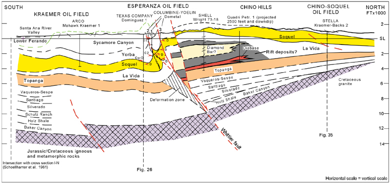
Figure 28. Kraemer oil field to Esperanza oil field and the Chino Hills. This section is the best illustration in the area of the striking differences in thickness between the La Vida Member on the north and south sides of Whittier fault; these are inferred to indicate Miocene rifting (Bjorklund and Burke, 2002). Approximately one mile north of the Whittier fault, the Shell Wright 73-18 well penetrated over 4000 feet of La Vida siltstone, rift deposits, and diabase. Nearly 1500 feet of that interval is the Diamond Bar sandstone, which is not present south of the Whittier fault. The equivalent interval approximately one mile south of the Whittier fault in the Texaco Travis 1 well, which is located 3000 feet southeast of this section, is 1510 feet thick and contains no significant sandstone units or diabase. Even if the La Vida Member were somewhat thicker northwest of the Travis well and if the La Vida Member were repeated by unrecognized faults in the Wright well, the conclusion that rift deposition north of the Whittier fault must account for the differences in thickness seems inescapable. The structural features associated with the hanging wall and footwall blocks of the Whittier fault are similar to those found at Brea-Olinda oil field; that is, steeply dipping, faulted forelimb beds and gently dipping backlimb beds. However, at Esperanza, the structural interpretation of the basement block is largely conceptual because of the lack of deep wells and has been derived from constraints imposed by bed length and area assumptions (See Bjorklund and Burke, 2002, Fig. 12, Appendix A, for a discussion of balancing methodology). Any structural interpretation must account for 5000 feet of uplift of the north block of the Whittier fault. The interpretation of the stratigraphic units below the Vaqueros and Sespe Formations are based on USGS cross sections in the Santa Ana Mountains (Schoellhamer et al., 1981). The Pleasants sandstone is inferred not be present. The Schulz Ranch sandstone and the Silverado Formation have been interpreted to be thinner than the closest subsurface control, which is in the Texas Company Irvine NCT-1 No. 1 well to the southeast. See Figure 24 for details on the Esperanza oil field.