RECENT AND PLEISTOCENE GEOLOGY OF THE CALCASIEU ENTRENCHED VALLEY SYSTEM OF SOUTHWEST LOUISIANA
With special reference to Near-Surface Geological Features of Importance to Seismic Exploration
Rufus J. LeBlanc
Search and Discovery Article #60004 (2000)
Report 128,
Houston, Texas, November 30, 1949, Shell Oil Company, Exploration and
Production Research Division ![]()
- List of Illustrations
- Introduction
- Purpose
- Location of area studied
- Source of data
- Drilling program
- Physiography
- Prairie Terrace
- Recent Surface
- Continental Shelf
- Stratigraphy of Near-Surface Deposits
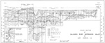
- Stratigraphy Along Cross-Spreads (Lines B-B' and C-C')
- Near-Surface Structural Conditions
- Resume of Late Geological History
- Late Pleistocene Epoch
- Recent Epoch
- Summary and Conclusions
- References
 Figure
1. Physiographic Features of Southwest Louisiana
Figure
1. Physiographic Features of Southwest Louisiana
 Figure
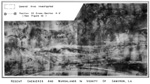
2. Recent Chenieres and Marshlands in Vicinity of Cameron, Louisiana
Figure
2. Recent Chenieres and Marshlands in Vicinity of Cameron, Louisiana
![]() Figure
3. Location of Borings and Geological Cross Sections
Figure
3. Location of Borings and Geological Cross Sections
![]() Figure
4. Relationship of Calcasieu Trench Slope to Slope of Continental Shelf
Figure
4. Relationship of Calcasieu Trench Slope to Slope of Continental Shelf
 Figure
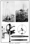
5. Drilling Equipment;
Figure
5. Drilling Equipment;C. Two views of cup-type sampler constructed for general sampling.;
D. Sixty-pound-weight apparatus used for driving and pulling out cup sampler shown in photo C.;
G. Assembled 2-inch split-spoon core barrel.
 Figure
6. Distribution of Quaternary Abandoned Beaches in Gulf Coastal Plain
Figure
6. Distribution of Quaternary Abandoned Beaches in Gulf Coastal Plain
 Figure
7. View of Chenieres from Mud-Flat Area in Vicinity of Boring 20
Figure
7. View of Chenieres from Mud-Flat Area in Vicinity of Boring 20
 Figure
8. Cross Section of Calcasieu River Entrenched Valley at Lake Charles,
Louisiana
Figure
8. Cross Section of Calcasieu River Entrenched Valley at Lake Charles,
Louisiana
 Figure
9. Subsurface Contours-Top of Pleistocene Deposits Showing Position of
Calcasieu River Entrenched Valley System
Figure
9. Subsurface Contours-Top of Pleistocene Deposits Showing Position of
Calcasieu River Entrenched Valley System
 Figure
10. Cross Section of Calcasieu River Entrenched Valley System, Vicinity of
Cameron, Louisiana
Figure
10. Cross Section of Calcasieu River Entrenched Valley System, Vicinity of
Cameron, Louisiana
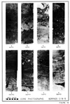
 Figure
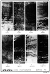
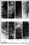
11. Core Photographs-Boring 7-X ;
Figure
11. Core Photographs-Boring 7-X ;
A. Yellowish gray, organic sandy clay. Near top of Unit 10.
B. Yellowish gray, organic clay and clayey sand. Lower part of Unit 10.;
C. Soft gray silty sand, Unit 9-A.;
D. Firm sand and sandy clay lenses in firm clay Unit 8.;
E. Soft gray clayey sand of Unit 7.;
F. Dark brown organic clay and wood of Unit 6.;
G. Medium to coarse sand in upper part of Unit 4.;
H. Reddish brown, thinly bedded stiff clay. Upper part of Unit 3
 Figure
12. Core Photographs-Borings 7-X and 1-S;
Figure
12. Core Photographs-Borings 7-X and 1-S;
A. Light gray, firm organic clay in lower part of Unit 3, boring 7-X.;
B. Medium to coarse sand of Unit 2, boring 7-X.;
C. Coarse sand with minor clay lenses near base of Unit 2, boring 7-X.;
D. Very hard, slightly oxidized, homogeneous green Pleistocene clay underlying Unit 1, boring 7-X.;
E. Sand lens in very stiff green Pleistocene clay, boring 7-X.;
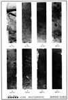
 Figure
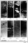
13. Core Photographs-Boring 16-A;
Figure
13. Core Photographs-Boring 16-A;
A. Gray clay and sandy clay of Unit 11.;
B. Shell layer in soft clay of Unit 9.;
C. Fragments of clam Rangia cuenata and Ostrea sp. occurring in upper part of firm clay Unit 8.;
D. Firm gray clay near top of Unit 8.;
E. Soft gray organic clay in upper part of Unit.;
F. Dark brown organic clay and wood in middle of Unit 6.;
G. Firm gray clay with minor sand lenses in Unit 1.;
 Figure
14. Cross Section B-B'-Surface and Subsurface Distribution of Beach and
Mud-Flat Deposits and Their Relationship to Other Deposits
Figure
14. Cross Section B-B'-Surface and Subsurface Distribution of Beach and
Mud-Flat Deposits and Their Relationship to Other Deposits
 Figure
15. Cross Section C-C'-Surface and Subsurface Distribution of Beach and
Mud-Flat Deposits and Their Relationship to Other Deposits
Figure
15. Cross Section C-C'-Surface and Subsurface Distribution of Beach and
Mud-Flat Deposits and Their Relationship to Other Deposits
 Figure
16. Core Photographs-Borings C-1 and l-S;
Figure
16. Core Photographs-Borings C-1 and l-S;
A. Brown beach sand of Bed H, boring C-1.;
B. Organic clay with layers of brown sand, Bed G, boring C-1.;
C. Light tan organic clay of Bed E, boring C-1.;
D. Gray, firm marine sand with shells, Bed D, boring C-1.;
E. Uniform soft gray clay of Bed E, boring C-1.;
F. Greenish gray sandy clay and shell layer of Bed C, boring C-1.;
G. Soft gray sandy clay with few shells, Bed B, boring 1-S.;
 Figure
17. Core Photographs-Borings C-2 and C-3;
Figure
17. Core Photographs-Borings C-2 and C-3;
A. Sand soil with roots. Bed J, boring C-2.;
B. Brown beach sand, Bed I, boring C-3.;
C. Brown beach sand in upper part of Bed I, boring C-2.;
D. Brown beach sand with lenses of sandy clay, lower part of Bed I, boring C-2.;
E. Brown beach sand, with shell fragments, in lower part of Bed I, boring C-2.;
F. Soft, gray clayey sand near base of Bed E, boring C-3.;
G. Very firm gray sandy clay, upper part of Bed B, boring C-3.;
H. Very firm clayey sand and sand with scattered shells. Middle part of Bed A, boring C-3.
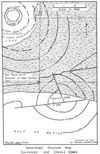 Figure
18. Generalized Structure Map - Calcasieu and Creole Domes
Figure
18. Generalized Structure Map - Calcasieu and Creole Domes
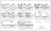 Figure
19. Stages in the Development and Alluviation of the Calcasieu River
Entrenched Valley System
Figure
19. Stages in the Development and Alluviation of the Calcasieu River
Entrenched Valley System
Purpose
This geological research project was carried out in conjunction with a seismic research project which was conducted by Dr. E. Merten of the Physical Department of this organization. The purpose of this report is to present the geophysicists with all available data concerning the surface and near-surface geological. conditions of the area in which this study was conducted and to outline such features as are definitely considered to have some effect on both the quality and character of seismic reflections and velocities.
The area studied in connection with this project lies in Calcasieu and Cameron parishes, Louisiana. Although a general geological study of the whole region outlined in Figure 1 was conducted, a more detailed study of physiography and stratigraphy was confined to a four-mile area along Louisiana Highway No. 42 just east of Cameron, Louisiana (see T14S and T15S, R8 and R9, west, Figures 2 and 3). The area outlined above was selected for this study because, as a result of previous studies (Le Blanc, 1949) there were known to exist in the area several types of surface and near-surface geological features which were suspected of having possible influences on seismic records and interpretation.
This report is based on analyses of numerous data which were derived from three main sources. The bulk of the data was obtained from a boring program, which was conducted for the purpose of drilling shot-holes and establishing subsurface correlations with field studies and interpretations of aerial photographs of the region. Information obtained from the above sources was supplemented by logs of borings procured from the Waterways Experiment Station, Vicksburg, Mississippi; the New Orleans Office of the U. S. Engineers; and the Louisiana Department of Highways, Baton Rouge, Louisiana. In addition, some data on the general subsurface structural conditions of the Cameron Parish region were obtained from the Geological Department of the Lake Charles district office of this company.
A total of 24 shot-hole borings ranging in depth from 30 to 200 feet were drilled by the experimental crew of the Physical Department. All borings drilled along line A-A' (see Figures 2 and 3), with the exception of one, and the three borings drilled along lines B-B' and C-C' were drilled with hand equipment. Inexpensive fish tail bits and regular shot-hole casing equipped with a water-pump apparatus were used. The drill stem was rotated with large wrenches, and in cases where drilling was difficult a special wheel was used (see Figures 5-B and 5-R'). Hole No. 21 along line A-A' was drilled by the portable rotary rig (see Figure 5-A). Since these wash borings were drilled during the months of March and April, water for use in drilling was available in large quantities along highway ditches and in mud flats.
In order to obtain as much information as possible concerning the nature and distribution of the various types of sedimentary deposits penetrated by the borings, all of the shot holes outlined above, with the exception of numbers 9 and 10, were logged and sampled by the writer. Reliable cuttings were generally obtained in those holes where the deposits consisted predominantly of clay and silty clay. In other holes, where a considerable amount of sand was encountered, difficulties were experienced in obtaining cuttings. It was not possible to mud off these loose sand beds with the hand equipment used to conduct this work.
In addition to the shot holes mentioned above it was necessary to drill twenty-five shallow borings ranging in depth from 5 to 20 feet with 4-inch hand augers. These borings were drilled along lines B-B' and C-C' (see Figure 3) in order to determine the relationships of the near-surface deposits to topographic features of the area.
Following the completion of the shot-hole drilling program at the end of April, the geological information obtained from the logs and samples was analyzed in the Laboratory. From these data it was possible to establish the subsurface correlation of beds encountered with the drill where good cuttings were available. However, due to the lack of reliable cuttings from the sand sections it was necessary to supplement the wash borings with a few core borings in critical areas. Since equipment suitable for this type of work was not available at the Laboratory it was decided to construct a special type of cup-sampler and a split-spoon core barrel similar to that being used for sampling the Recent and Pleistocene beds of southern Louisiana by the boring section of the U. S. Engineers. A 14-foot tripod, equipped with block and tackle necessary to handle the 60-pound weight used to drive the sampler or core barrel by hand, was also built (see Figures 5-C and 5-D). Personnel to operate this equipment were employed in Lake Charles, Louisiana, and were supervised by a laboratory assistant. Although this equipment had been operated very successfully by hand for several years by the U. S. Engineers it proved to be entirely unsatisfactory for our work under the conditions which existed at the time. Two 2-inch split-spoon core barrels (see Figures 5-F and 5-G) for use with the large portable drilling rig were then constructed and utilized in coring holes No. 71, 16-A,. and C-3. A Louisiana crew, engaged to conduct this work, operated under the supervision of Mr. A. L. Sheppard, of the Exploration and Production Research Division.
Samples from the auger and wash borings were preserved for laboratory analyses in tightly sealed glass jars. All of the 1-inch and 2-inch cores were sealed air-tight in paraffin and placed in regular 3-inch mailing tubes in the field. The cored material, with its original moisture content, was thereby preserved for future use in connection with studies of Recent sediments as related to environments of deposition.
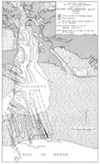
That portion of the Gulf Coastal Plain which comprises southwestern Louisiana is characterized by two distinct physiographic types: a broad gulfward-sloping inland terrace and a belt of coastal marshland (see Figure 1). The surface of all of central and southern Calcasieu Parish and of the northern one-quarter of Cameron Parish is made up of the lowest and youngest of the four Pleistocene terraces which occur in Louisiana, namely, the Prairie terrace. The region to the south of this terrace consists, of extremely flat Recent marshlands and large inland lakes, which represent some of the youngest land added to the North American continent.
The Prairie terrace varies in elevation from approximately 20 feet in the latitude of Lake Charles to about 2 1/2 feet to 3 feet in the latitude of Hackberry Ridge, where the terrace passes under the Recent marshland deposit.. This terrace surface slopes seaward at an average rate of about 1 foot per mile, and its continuity is interrupted d only by the younger and lower surfaces of the alluvial valleys occupied by the numerous streams which flow across the region from north to south The principal streams from west to east are: Sabine River and its tributary, Black Bayou; the Calcasieu River, which flows from Lake Charles to Calcasieu Lake through the center of the region under consideration; and Bayou Laccasine at the: eastern edge of the area (see Figure 1).
Interpretation of aerial photographs of the Cameron and Calcasieu area reveals that the surface of the Prairie terrace holds traces of the many streams which constructed this coastal-plain surface during Late Pleistocene time. In the area east of the Calcasieu River,and within a narrow 6-mile-wide strip west of the Calcasieu River, old channels of the Red River form the principal topographic features on the terrace surface These old channel lowlands are aligned in the northeast-southwest direction and are flanked by alluvial ridges formed by coalescent natural levee ridge and point-bar features. The principal drainage lines of the area east of the Calcasieu River follow these old abandoned Red River courses. Some of the channels can be traced to the southern extremity of the terrace (see, for example, Hackberry Ridge, Figure 1) where they pass beneath the Recent deposits. Other old courses lead into minor stream valleys which were entrenched at the close of the Pleistocene Epoch.
Practically all of the Prairie terrace surface in Calcasieu Parish is covered by the well-known pimple mounds of questionable origin which characterize most of the Gulf Coastal Plain west of the Mississippi River. Since these pimples do not exist on the Recent surface they serve as a very useful criterion in recognizing the contact between the Recent and Pleistocene surfaces in areas where the contact between the two is otherwise imperceptible. Where the Prairie terrace has been buried by only one or two feet of Recent deposits, the pimple mounds can be seen to protrude through the marshlands to form islands which support a growth of vegetation quite different from that characterizing the marshlands. In extreme northern Cameron Parish many large islands of Prairie terrace exist within the marshlands (see Pines Ridge and Marceaux Island on Figure 1).
The terrace surface between the Sabine and Calcasieu rivers is less well known than that to the east. The topographic features of this area have not been studied for this project because they are in no way related to the deposits which occur in the subsurface at the site investigated. Enough is known about this surface, however, to recognize it as an old Pleistocene alluvial plain similar to the old plain of the Red River but constructed by smaller streams.
The surface of the coastal plain of Calcasieu and Cameron parishes, which is considered to have been developed during the Recent Epoch; can be divided into three distinct units on the basis of physiography. These are: wooded alluvial valleys, (swamplands); marshlands and lakes; and abandoned beach ridges (see Figures l and 2).
The Sabine and Calcasieu rivers,as well as the other minor modern streams of the area, are flowing through broad alluvial valleys which were carved out of the Prairie terrace during the last glacial stage of late Pleistocene time. Unlike the Prairie terrace surface, these alluvial valleys are very swampy, possess practically no relief whatsoever, and merge with the marshlands to the south. The alluvial valleys of the streams other than the Calcasieu River are not discussed herein since they bear no direct relationship to the problem.
Calcasieu River alluvial valley.
The wooded valley of the Calcasieu River ranges in width from 1 mile to 2 1/2 miles in the latitude of Lake Charles to a maximum of about 3 miles at the Cameron-Calcasieu Parish line. Here it merges with Calcasieu Lake, which has a maximum width of 7 miles and is usually less than 5 feet deep. South of Calcasieu Lake, Calcasieu River flows across Recent marshlands for a distance of about 6 miles.
The slope of this valley is less than that of the Prairie terrace, its elevation being about 3 feet to 4 feet above sea level at Lake Charles and only 1 foot or 2 feet above sea level near the north end of Calcasieu Lake, Throughout its length, the Calcasieu valley surface is characterized by numerous abandoned channels and other traces of stream activity left behind by the constantly shifting river. The river widens locally to form several small shallow lakes such as Lake Charles, Prien Lake, and Moss Lake (see Figure 1).
The alluvial valleys of the Calcasieu and Sabine rivers merge with the coastal marshlands in the latitude of southern Calcasieu and northern Cameron parishes. This Recent surface, unlike the Prairie terrace surface, shows no evidence of numerous abandoned stream channels which is so typical of alluvial and. deltaic plains. Instead, the topographic features as determined from analyses of aerial photographs indicate that the marshlands of this area, except for a small belt in the south one-quarter of the parish, now occupy the position formerly held by a broad lagoon or back-bay area lying between the Prairie terrace to the north and abandoned beach ridges to the south. Calcasieu Lake, which marks the southern extension of the Calcasieu valley is considered to represent the unfilled portion of an estuary whose connection with the Gulf of Mexico has been completely sealed, except for the narrow channel of the Calcasieu River, by the construction of beach ridges associated with a marine environment of deposition.
An examination of the north shore of the Gulf of Mexico along Cameron Parish shows that the Gulf is in the process of transgressing over the marshlands in some places, while it is evident that accretion is being made to the mainland and regression is now in effect in other locales. Marine sand beaches occur over less than one-half the coastline of Cameron Parish. (see Figure 1). The best developed beaches occur between the Calcasieu and Sabine rivers and are named as follows from west to east: Ocean View, Peveto, and Holly Beach. A single beach, Hackberry, occurs east of the Calcasieu River.
The coast between Sabine River and Ocean View Beach and between the Calcasieu and Mermentau rivers consists of broad mud flats where large quantities of mud and only a small amount of sand are being deposited at the present time This is considered as evidence of a modern local marine regression. It is in this area that accretions are presently being made to the Louisiana coast.
The modern beaches of southwestern Louisiana are typical of the beaches associated with a constantly changing coast line bordering a coastal plain. The character of the beaches varies from those which are stable and well developed to those which are incipient and active. Holly Beach, for example, is rapidly advancing and is therefore a young beach. It rises only a maximum of 6,1/2 feet above sea level and 4 feet to 5 feet above marsh level and attains a maximum width of only 300 feet. Older, more stable beaches to the west attain maximum elevations of over 12 feet above sea level and are somewhat wider.
Mud flats of the Cameron coast vary from a few feet to over 500 feet in width and rise only a few inches above tide. Unlike the associated beaches, they do not rise above the level of the marshlands. During the summer months these mud. flats support a flora, the roots and stems of which usually become incorporated in the mud-flat deposits.
Between the coastal marshlands of Cameron Parish to the north and the present shoreline of the Gulf of Mexico to the south there lies an east west belt of coastal plain attaining a maximum width of 10 miles which is characterized by a series of east-west linear ridges separated by flat, low-lying marshy areas (see Figures 1 and 2). The ridges which rise to elevations of as much as 12 feet above sea level (10 feet above marshland level) are similar in many respects to those of the present beach ridges discussed above. Because they support many large live oaks, they have long been referred to as Chenieres, from the French word "Chene" meaning oak tree, These ridges are formed by abandoned beach deposits stranded in the marshlands as the shoreline of the Gulf of Mexico moved southward during the latter part of the Recent Epoch (Russell and Howe, 1935; Howe, Russell, and McGuirt, 1935) . The low areas between the beaches represent fossil mud flats now covered by marsh vegetation.
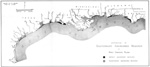
The occurrence of abandoned beach ridges in the Gulf Coast is not limited to the Cameron area nor is it restricted to the Recent surface. The presence of similar features in other parts of the Gulf Coast has been observed as a result of examination of aerial photographs of the Coastal Plain from Brownsville, Texas, east to Apalachicola, Florida. The distribution of abandoned beaches on the Pleistocene and Recent surfaces in this region is shown on Figure 6.
The chenieres of southern Cameron Parish fall into two main groups. The larger group lies east of the Calcasieu River and extends for a distance of 45 miles (Le Blanc, 1949- Figure 1). This belt is less than four miles wide near Cameron and gradually increases to a maximum of 11 miles in townships 14 and 15 north, range 16 west There is a distinct relationship between the width of the belt and the space between chenieres. In the Mermentau River area, the ridges are broadly arcuate, well-defined, and separated by wide mud flats, leading to the conclusion that the regression of the gulf was comparatively rapid. In the Creole and Cameron area where the regression seems to have been at a much slower pace, many chenieres occur adjacent to one another, and as a result of this they have the appearance of being one single ridge. Close examination of photographs, however, reveals the presence of accretion lines indicating alternating ridges and mud flats within the coalescent area.
The second group of abandoned beach ridges lies in the extreme southwestern part of Cameron Parish (see Figure 1). The area occupied by these ridges is about 7 miles wide along Sabine River and Sabine Lake and gradually tapers eastward to Peveto Beach where the modern shoreline is advancing on the marshland, and the chenieres are completely absent. The majority of the ridges trend in an eastward direction then turn very abruptly to the northwest, clearly indicating their association with the development of Sabine River and a former channel of the Calcasieu River, now occupied by Hamilton Lake. These ridges attain elevations and widths comparable to those east of the Calcasieu River.
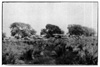
The distribution of fossil beach ridges and mud flats in the area investigated along Louisiana Highway No. 42 is shown on Figure 3. The principal ridge north of the highway reaches its maximum elevation of about 6 feet near the eastern end of the line and rises to an elevation of 8 feet near the western end of the area drilled (see Figure 7). The intervening mud flats are only 1 1/2 feet to 2 feet above sea level.
Holes No. 1-14 inclusive were drilled along the south edge of the main ridge, which bifurcates at Hole No. 15. Borings 16 through 20 were drilled along the south edge of the north fork of the ridge. The relationship of the topography to the borings drilled for the cross-spreads along lines B-B' and C-C' is shown on Figure 3.
Another feature which is closely associated with the coastal plain of southwest Louisiana, and worthy of consideration here, is the broad submarine plain called the Continental Shelf, (see Figure 4). The slope of this shelf opposite the Cameron coast is very gentle for the first 145 miles, averaging about 1.2 feet per mile. For the next 12 miles the slope increases to nearly 15 feet per mile to the edge of the continental slope where the gradient averages 64 feet per mile down to the-3000-foot line.
Although the floor of the Gulf appears to be very smooth from the cross-section shown in Figure 4, there are actually many irregularities in the Gulf bottom. Some of these features, such as the shallow areas off the mouths of the Calcasieu and Sabine rivers, reflect the deposition of the deltaic sediments into the Gulf by these rivers. Other larger features such as Sabine Bank remain to be explained, while smaller features are known to be salt domes. There seems to be no evidence of submarine canyons similar to that which exists near the mouth of the Mississippi River.
STRATIGRAPHY OF NEAR-SURFACE DEPOSITS
The nature and distribution of the sedimentary deposits of a comparatively young coastal plain, such as that of southwestern Louisiana, are very closely related to the topographic features formed by the depositional and erosional processes associated with the continental, deltaic, and marine environments within which the coastal plain was constructed. The writer is thoroughly familiar with numerous examples in the lower Mississippi valley where direct correlations between physiography and near-surface stratigraphy have been made and tested through a combined analysis of aerial photo and boring data (Fisk, 1944; Fisk, 1947; Mississippi River Commission, 1940-1947). The stratigraphic information presented below has been derived from such studies, utilizing previous knowledge of the general geology of the area, and from a detailed analysis of the local relationships between topography and the character of underlying deposits as observed in borings.
The late Pleistocene deposits which comprise the upper part of this formation are well-indurated and dip seaward at the rate of about 1 foot to 4 feet per mile. They consist of fluviatile deposits laid in the continental environment of deposition, typical marine sediments deposited in the neritic zone of the continental shelf environment, and sediments laid down in the less well-known intermediate environment herein called deltaic.
As previously pointed out (Le Blanc, 1949 - page 44) the general character of these beds is fairly well known in southwestern Louisiana from the unpublished results of earlier work. Additional information derived from this project and from the examination of excavations for lock sites in Cameron and Calcasieu parishes has also been analyzed and integrated with material previously acquired.
The sediments which comprise the surface beds and the first 5 feet to 60 feet of section of the Prairie formation in the Red River alluvial cone area of eastern Calcasieu Parish and north-central Cameron Parish consist predominantly of fluviatile clay, silt, and sand, and various combinations of these textural groups varying in color from light brown to red. Having been deposited by ancestral Pleistocene Red River courses, these sediments are very similar in character to the modern sediments of the Red River valley of central Louisiana. Locally brackish water deposits are found to interfinger with fluviatile sediments mentioned above.
Underlying the red-bed member of the Prairie formation discussed above is a thick section of older greenish-gray clay with lenses of clay sand and sand which are predominantly of fresh and brackish water origin.
The Prairie beds in the area west of the Calcasieu River, away from the Red River alluvial cone, lack the usual red color of the Red River materials since their source area was in no way associated with the red-bed area of northern Texas and southern Oklahoma from which most of the Red River sediments were derived. Little information is available on the general characteristics of these beds; however, in the few localities where examined they consist of gray clay, silk and sand laid down in environments similar to those which existed east of the Calcasieu River.
The occurrence of Prairie beds in the subsurface, south of the outcrop area of the Prairie terrace beneath the Recent sediments filling the alluvial valleys, is fairly well. known throughout southern Louisiana. The contact between the Recent and Pleistocene, where observed in lock site excavations and in cores, is unconformable. Compilation of available data has shown this contact to be very irregular (Le Blanc, 1949, Figures 13, 15, and 20). The buried Pleistocene surface is characterized by a series of entrenched valleys which are separated by broad, gently rolling divides (see Figures 8 and 9). This eroded surface is considered to have been developed during the last Pleistocene Ice Age when sea level was lower by approximately 450 feet and all the streams of the Gulf coastal area were enabled to entrench their valleys deeply. During this stage of erosion the Pleistocene deposits were exposed to the surface for a long period of time and were weathered and oxidized. Thus the typical calcareous Red River deposits which formed this old land surface were changed from dark brown and red to shades of yellowish brown, and those of the other streams originally gray in color were oxidized to yellowish gray and brown color (and subsequently buried under dark gray, and very soft, Recent deposits). Leaching of the Pleistocene beds above the ground-water table during this stage of erosion resulted in a concentration of calcium carbonate near the upper part of the buried Pleistocene surface.
Pleistocene Deposits Along A-A'
A total of 23 borings have been drilled through the Recent deposits and into the older Pleistocene beds within the area investigated. Of these, 8 were sufficiently deep to penetrate the red-bed member of the Prairie formation occurring in the subsurface at subsea elevations of 20 feet to approximately 100 feet These beds consist of very hard calcareous clay with scattered lenses of coarser materials ranging in color from red to brown (see Figure 10), The upper part of this layer which represents an old soil zone developed above the water table, is weathered and predominantly yellowish gray in color.
The character of the green clay underlying the Red River deposits is less well known at the site studied. Only one boring, No. 11, drilled to a depth of 200 feet, penetrated 100 feet of this material. Where encountered elsewhere in the subsurface of Calcasieu and Cameron parishes, and in a well in the Gulf 25 miles offshore south of Cameron, Louisiana, this clay layer is very dense and uniform.
All of the alluvial materials deposited in the Gulf Coastal Plain since the beginning of the rise in sea level at the close of the latest Pleistocene Ice Age are considered to be of Recent Age. Deposits of this age occur in southwestern Louisiana throughout the area shown in white on Figure 1, that is, beneath the marshlands and alluvial valleys. Like the older Pleistocene deposits, the general physical properties of the Recent sediments are fairly well known from previous studies, (Le Blanc, 1949 - pp 39-44). However, integration of this information will additional data obtained in the course of this investigation has considerably broadened our knowledge of these deposits.
Recent stratigraphy along line A-A'
A cross section of the Recent deposits which were penetrated along line A-A' is shown on Figure 10.
- The Recent mass can be divided into the following major sections:
- a. Soil zone (Units 10 - 11) overlying beach sand and mud-flat clay. 5 to 10 ft thick.
- b. Upper section (Units 7 - 9-A) of heterogeneous, soft marine clay interfingering with soft silty sand and sand laid down in deltaic environment. Thickness varies from 40 to 50 ft.
- c. Middle layer. (Unit 6) of organic clay containing layers of peat, matted vegetation, logs, etc. 5 to 12 ft thick.
- d. Basal section (Units 1 - 5) of interbedded fluviatile sand and clay layers. Thickness varies from 25 ft to 125 ft.
-
The occurrence of deposits belonging to this section of beds is confined to the deepest part of the Calcasieu entrenched valley system below subsea elevations of approximately 60 feet. The following is a description of the various units into which this group has been subdivided. (The circled numbers on Section A-A', Figure 10 correspond to the numbers listed below.)
Unit 1: A thin basal layer of fine clay occurring in deepest portion of Calcasieu entrenched valley and along the deep marginal area of the tributary trench between borings 19 and E1. Lies directly over Pleistocene clay in holes 5 and 17. Most of this clay was probably derived from Pleistocene beds being eroded at the very beginning of Pleistocene time.
Unit 2: Fine to medium sand layer restricted to deepest part of entrenched valley system (see Figures 12B and 12C). Contains scattered layers of clay, silty sand, and wood. Interfingered with very hard and stiff clay along the margins of the trench. Alternating hard arid soft layers, usually gray in color. Typical of many other sand bodies filling similar entrenched valleys in the Gulf Coast area.
Unit 3: Fairly uniform stiff clay occurring as minor lenses only a few feet thick in the west part of the entrenched valley system and as a well-defined 18-foot to 32-foot bed in the main trench between borings 10 - 5 inclusive (see Figure 11-H). Predominantly thinly bedded silty clay with some sandy lenses; brownish gray to reddish brown in color and somewhat similar in general appearance to the upper hard clay of the Pleistocene deposits which mark the top of the Pleistocene between borings 1 - 4 and E-16,; however, it is less indurated and has slightly higher water content. Sediments derived from the red-clay member of the upper Pleistocene, probably from the wide divide areas to the north. Predominantly of fluviatile origin with occasional interbeds of fine-grained layers carrying what appears to be a brackish-water fauna.
Unit 4: Consists of a sand bed very similar to Unit 2, (see Figure 11-G). Confined to major trench between borings 5 - 10 inclusive with thicknesses varying from 15 feet to 30 feet. Consists of fine to coarse sand with layers of wood and other organic matter in western portion of trench between borings 8 - 10 and also of clay sand layers in the east portion of trench between borings 7-X - 5. Color varies from dark gray to white. Considered to have been deposited by braided streams carrying mostly sand.
Unit 4-A: Soft clay occurring in the west central portion of the Calcasieu trench in borings 7X, 8, and 20, at elevations of -67 feet to -97 feet. Thickness varies from zero to a maximum of 27 feet. Consists of soft brownish gray uniform clay with no apparent bedding; high water content. Presumably laid down in a back-swamp environment contemporaneous with deposition of sand along flanking alluvial ridges.
Unit 5: Confined to the Calcasieu River trench at elevations of approximately -55 feet to -85 feet. Encountered in all trench borings except E-2 and 6. Thicknesses ranging from 0 to a maximum of 15 feet. Lithology consists of very fine, stiff clay and silty clay varying from yellowish gray to green in color. More indurated than both units 4-A and 3 but less indurated than the Pleistocene clay. Water content comparatively low.
Unit 6: Organic clay stratum found only in the entrenched valley area at elevations -55 feet to -68 feet between borings 5 - 10 inclusive and 15 - 18 inclusive. Average thickness about 10 feet in. Calcasieu trench and about 7 feet in the tributary trench to the west. Lithology varies from very fine organic rich clay to beds of wood, matted vegetation, peat, and logs (see Figures 11-F and 13-F). Contains lenses of clay, sand, and silty sand locally. Color varies from dark black to brownish gray and dark brown. Clays are usually soft and spongy with an extremely high water content, Deposits similar to this are presently being formed in swamp environments throughout the southern Gulf Coastal Plain.
Unit 7: Consists of very soft clay with occasional lenses of harder sandy clay and silty sand (see Figure 11-E). Observed only in the Calcasieu trench area between borings 4 and E-3. Much softer than clay Units 5 and 3 but very similar to Unit 4-A. Different from all other clay beds discussed above in manner of deposition; fauna indicates unit was deposited in a deltaic environment. Species now found living in brackish water environment were observed in this unit. Top elevation of this unit corresponds roughly to highest elevation of Pleistocene deposits occurring in the divide area between trenches.
Unit 8: Consists of a very widespread clay layer varying in thickness from 10 feet to 37 feet (see Figures 11-D and 13-C and D). Represents firmest material encountered above organic clay layer No. 6. Predominantly fine clay with lenses of silty clay and sandy clay; consistently similar to that of Bed 3. Fauna and character of lithology indicate that unit represents material. laid down as sea level trangressed into a Calcasieu trench system and over the divide areas during a period of time when the Calcasieu estuary extended far upstream.
Unit 9: Soft clay unit; attains its maximum distribution over the Pleistocene divide areas, that is, between borings 1 - 5 and 11 - 15. It is also present over the trench areas where it is interbedded with Unit 9-A. Thickness varies from lenses just a toot or two thick to a maximum of about 25 feet. Clay is very fine, uniform in character and has a very high moisture content; :Less firm than Bed 8 which it overlies. Marine fauna found in this unit is similar to that in Bed 8 (see Figure 13-B); considered to have been deposited as a gulf-bottom sediment in the area flanking the delta of the Calcasieu River.
Unit 9-A: Represents the coarse phase of Unit 9. Consists largely of silty sand, clayey sand, and sand lentils with occasional minor clay layers (see Figure 11-C). Its thickness varies from 0 to 25 feet. This unit occurs in the Calcasieu trench and the minor tributary trench to the west. Like clay Unit 9, it is very soft and gray to dark gray in color, with numerous scattered shell bodies. This unit is considered to represent typical delta deposits interfingered with the delta flank sediments of Bed 9-A.
Abandoned beach and mud-flat section.
Unit 10: Sand and clay unit encountered in all of the borings in line A-A', except in the extreme western end in borings numbers 18, 19, and E-16. Its thickness varies from 1 foot to 7 feet, and it consists of fine brown beach sand with layers of brownish gray sandy clay; clay, organic clay, and sandy clay which are associated with the mud-flat deposits (see Figure 11-A and 11-B). Materials of this unit represent the gulfward edges of the abandoned beach sand forming the ridges north of Louisiana Highway 42 from borings 1 to 17.
Unit 11: Represents a soil profile which has been developed over the seaward side of the large beach ridges. It consists of dark organic clay, silty clay, and sandy soils varying in thickness from 1 foot to 6 feet (see Figure 13-A). This unit, as well as Unit 10, is much thicker on the north side of the road where the majority of the seismometers were planted.
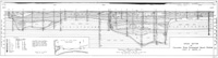
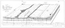
STRATIGRAPHY ALONG CROSS-SPREADS: (LINES B-B' AND C-C')
In order to determine the influence of the shallow beds and related topographic features upon seismic reflections and velocities, the near-surface geology shown on Figures 14 and 15 along lines B-B' and C-C' was developed. It is pointed out that more detail has been included concerning the lithology of the sediments shown on these two sections than along line A-A' (Figure 10). These block diagrams also show in considerable detail the exact relationships between topography and near-surface stratigraphy. It was not practical to drill below depths of about 17 feet with 4-inch hand augers; thus the sections are undifferentiated below depths of 15 feet to 20 feet. In order to avoid confusion with section A-A', letters (rather than numbers) have been used to denote the various units comprising these deposits. The positions of seismometers planted along these lines are also indicated.
The Pleistocene deposit upon which the Recent mass is resting has been sampled in six borings along this line. It consists of very hard, oxidized, yellowish-brown clay similar to that marking the top of the Pleistocene along line A-A' between borings 1 - 4 and E-3 to E-16. As indicated on Figure 14, there is absolutely no evidence of a trench along this line.
- The Recent deposits have been subdivided into three principal units:
- a) A basal marine section of alternately hard and soft layers of sandy clay, sand, and clayey sand
- b) Beach-deposits of fine sand with some clay lenses
- c) Clay and sandy clay of the mud flats
-
- The marine group of beds along this line corresponds to Unit 9 along line A-A'. It is made up of the following:
- Bed A: Section of soft interbedded clay, silty sand, etc. Few samples taken, therefore, not well known.
- Bed B: Soft sandy clay layer (Figure 16-G).
- Bed C: Thin shell bed which has been traced completely across this section (Figure 16-F).
- Bed D: Firm sand layer in south half of section grading northward into a lower firm clay sand (also labeled D) and an upper soft clay and sandy clay level (labeled E) (see Figure 16-D).
Beach ridges along the central and southern edge of the block diagram (Figure 14) are composed of fine, brown sand referred to as Unit 10 along line A-A and as Bed H along this line (B-B'). The beach deposit attains its maximum thickness of 8 feet beneath the highest part of the ridge just north of Highway 42. The seaward edge of the beach mass is well defined, whereas the landward side is usually interfingered with mud-flat clay and is much less well defined. Both the vertical and horizontal scale are included on Figure 14 to assist in determining the true relations of these deposits.
- Sediments belonging to this unit are shown as Beds F and G on B-B'.
- Bed F: Consists of a yellowish-gray clay with scattered organic material„ This clay varies from 0 to about 4 feet thick and is usually softer than the marine beds which it overlies. The contact between this unit and the marine sediments is very sharp and easily recognized in borings.
- Bed G: Similar to Bed F except for the fact that it contains more sand in the clay. Organic material is also present but probably in smaller quantities. Thickness of the bed varies from 0 to 3 1/2 feet. Its consistency is a little harder than the underlying organic clay.
- Bed I: Soil zone developed upon both the abandoned beach and mud-flat deposits. It is thickest over the ridges and thinnest over mud flats. It is usually sandy in ridge areas and very fine-grained in the flats.
-
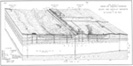
The near-surface geological conditions along this north-south line are similar to those along line B-B' discussed above (see Figure 15). The Pleistocene beds are composed of the same type of very hard oxidized clay. However, these beds occur at greater depths ranging from 38 feet at the north end of the section to 47 feet at the south end in boring C-37.
The Recent deposits are; divisible into the same units discussed under section B-B', that is, a basal marine section overlain by mud-flat and beach deposits.
- Marine section
- Bed A: The lower portion of this marine section is made up of firm clay and silty clay, rather than of soft materials like those which exist along line B-B' (see Figure 17-H) .
- Bed B: A very firm gray clay and sandy clay with considerable shell material. It; is easily recognized in auger borings by its firmness (see Figure 17-G) .
- Bed C: A soft clay and sandy clay layer overlying Bed B. Although this unit is referred to as soft in section C-C’ it is pointed out that it is considerably firmer than the deltaic deposits which occur over the trench as near-surface Beds 9-A.
- Bed D: The same shell bed as Bed C on line B-B'. It consists of a sand with numerous small shells and is seldom over 1 1/2 feet thick. It was observed in all of the holes except C-2, where attempts to sample this layer were unsuccessful.
- Beds E and F: A firm clay occurring in the north one-half of the section and grading into a firm sand and clayey sand (Bed F) to the south. Scattered shells are very common.
- Mud-flat deposits
- Beds G and H: Two units similar to Beds E and F along line B-B' . They consist of basal organic clay section and upper organic sandy clay layer.
-
- Beach Deposits
- Bed I: Discussed as Bed H along line B-B' ,. Fine sand belonging to this unit forms the ridges along section L'-C', At the north end of the section the beach sand attains its maximum thickness which is approximately 10 feet (see Figure 15):
- Bed J: This soil zone is thickest and most sandy over the abandoned beach areas and thinnest and most clayey in the mud-flat areas Most of the seismometers along line C-C’ were planted in this soil zone (see Figure 17-A).
-
NEAR-SURFACE STRUCTURAL CONDITIONS
- The regional dip of the surface and near-surface Recent and Upper Pleistocene beds of southwest Louisiana is seaward at very gentle rates The following observations concerning the structure of these deposits have been made:
- 1) The slope of the Prairie terrace from Lake Charles southward to where it passes under the Recent marshes is approximately 1 foot per mile.
- 2) The slope of the buried Pleistocene surface underneath the Recent marshland (as determined from the shallowest occurrence of Pleistocene material under the Recent deposits) is 1 foot per mile (Le Blanc, 1949 - Figure 13) ,
- 3) The base of ‑the Pleistocene Red River deposits (or the top of the underlying green clays) dips seaward from the north end of Calcasieu Lake to the present shoreline south of Cameron at a rate of 3 1/2 .feet per mile
- 4) The Pleistocene deposits at depths of about 200 feet dip seaward at about 4 feet per mile, and at a depth of 800 feet the seaward dip increases at about 10 feet per mile.
- 5) Control on the regional dip of the Recent deposits is extremely scarce. The only definite control on the local seaward dip of these deposits is that along sections B-B' and C-C', Figures 14 and 15, The dip of marine beds occurring beneath beach and mud-flat deposits averages about 8 feet per mile along section C-C', and increases very abruptly from boring 48 southward to C-3. To the east along section B-B' the dip of the marine beds in the northern half of this section (between holes 32 and 1A) is about 6 feet per mile. Southward across Highway 42 this dip flattens and is actually reversed in hole 22. It is the writer's opinion that these shallow marine beds reflect the position of the Creole salt dome known to occur in the region (see Figure 18).
The dips along section C-C' are considered to be abnormally high,, being greater than those of the older Pleistocene beds, and are considered to be associated with the west flank of the Creole field, The reversal of dip along B-B' (south of Highway 42) is believed to reflect the northwest shoulder of the Creole dome (see Figure 18). The importance of near-surface beds in the Recent and Pleistocene section as a useful tool in determining both local and regional structure cannot be overemphasized The occurrence of similar marine beds which reflect deep-seated structures in other parts of the coastal plain has been previously discussed (Le Blanc, 1949 - p 52 and Figure 27).
Holly Beach, west of Cameron, is considered to be one of the youngest modern beaches along the Cameron coast. This beach attains a maximum elevation of about 6 feet above sea level. The base elevation of the beach mass is at sea level or approximately 1 foot to 2 feet below the level of the marsh upon which the beach is being constructed. This implies that the marsh materials underlying the beach mass have been compacted or have subsided 1 foot to 2 feet.
The abandoned beach ridge along Highway 42, where this work was done, reaches a maximum elevation of 8 feet above sea level. The elevation of the bottom of each material beneath these ridges is about 5 feet below sea level (or approximately 7 feet below marshland) implying a minimum of 5 to 7 feet of local compaction of the underlying deposits.
RESUME OF LATE GEOLOGICAL HISTORY
The following brief summary of the geological history of development and filling of the Calcasieu entrenched valley system has been reconstructed from an interpretation of all factual data derived from this study. A series of block diagrams, designed to illustrate this history, has been developed and is shown on Figure 19.
During the latter part of the Pleistocene epoch just prior to the last glacial stage, the Red River flowed from Alexandria, Louisiana south-southwest across central Calcasieu Parish, thereby constructing a broad alluvial cone, previously discussed under physiography. The deposits laid down by the Red River deltas are now buried beneath the Recent mass (or may have been partially removed by subsequent erosion) and are not well known. The Red River was then diverted to the east just south of Alexandria, thereby abandoning its alluvial cone which is constructed across southwest Louisiana.
At the close of the Pleistocene epoch the Calcasieu River was flowing on the Prairie terrace surface over a position now occupied by the Calcasieu alluvial valley.
During the last Ice Age, sea level was lowered by approximately 450 feet and the shoreline was far removed from Cameron Parish (Le Blanc, 1949 - Figure 16). It was during this glacial stage that the Calcasieu River entrenched valley system was developed. Calcasieu River was enabled to cut a trench about 80 feet deep at Lake Charles and 180 feet deep east of Cameron (line A-A', Figure 10). This trench extended seaward probably to the edge of the continental shelf (see Figure 4). Diagram A, Figure 19 illustrates how the Calcasieu trench appeared at this stage.
The close of the last Ice Age was marked by melting of the ice caps and a rise in sea level. This decreased the gradient of the Calcasieu River and forced it to drop part of its sand load thus alluviating its trench in the latitude of Cameron (see Diagram B, Figure 19). The gradient of the tributary stream occupying the minor trench to the west of Calcasieu trench was still sufficiently great to permit this stream to continue entrenching its valley.
Deposition of sand by the Calcasieu River in the latitude of Cameron, Louisiana was then interrupted by a change in conditions. The gradient of the Calcasieu River was decreased to such a point that the river was no longer braided but rather probably assumed the characteristics of a meandering river, and it deposited Unit 3. Evidence for a similar interruption of sand deposition during early Recent time has been found in the alluvial filling of the Sabine River entrenched valley.
Conditions suitable for deposition of sand by the Calcasieu River and its tributary streams were again restored, and alluviation of the trench system with fine sand was resumed, thereby burying clay Unit 3. During this stage at least a portion of the main Calcasieu trench was characterized by a backswamp environment in which fine clays were being deposited (see Diagram D, Figure 19).
Due to a possible temporary halt in rising sea level (or a possible local uplift) deposits of sand ceased abruptly and the environment of deposition in the Calcasieu trench changed to that of a typical swamp. It was during this stage that Unit 6 of line A-A' was deposited. This marked the close of the continental environment of deposition in the Calcasieu trench
As a result of a sudden rise in sea level, local subsidence, or changes in valley slope relationships associated with valley alluviation the Gulf transgressed far inland into the Calcasieu trench system leaving the divide areas slightly above water (see Diagram F, Figure 19). Deposition in the deltaic environment, closely associated with a marine environment, resulted in the formation of Unit 7.
As transgression proceeded still further, the Cameron area was completely inundated (see Diagram G), The Calcasieu River and its tributary streams are believed to have maintained their positions above the deepest part of the filled trench because sediments typical of a deltaic environment are found at shallow depths above the trenches (Unit 9-A, Line A-A', Figure 10).
Following stage G, the Calcasieu River was diverted to the west at a point somewhere near the :northern half of Calcasieu Lake. The environment of deposition along line A-A' gradually changed from deltaic, as shown in Diagram G, to that of a marine environment. This environment has persisted until the present. It was during this stage that the series of beaches and mud flats was constructed in the area studied. The general conditions as they exist today are shown on Diagram H, Figure 19.
The physiographic, stratigraphic, and structural features of the Cameron area are associated with the principal geological events which occurred during late Pleistocene time and the Recent epoch. The following are conclusions concerning the surface and near-surface features considered to have definite influences on seismic reflections and velocities.
The four-mile section along Highway 42, east of Cameron, Louisiana, is underlain by an entrenched valley system of the Calcasieu River which was eroded during the last glacial stage of the Pleistocene epoch and filled during the Recent epoch.
The main Calcasieu River trench is approximately 6500 feet wide and 200 feet deep, and the tributary trench to the west is 100 feet deep and 5500 feet wide, The floor of the Calcasieu trench system consists of very hard to stiff Pleistocene clay containing some sand and sandy clay lentils. These deposits are considerably more indurated and homogeneous than the younger Recent deposits which overlie them Where tested by the soils engineers* at several localities in southern Louisiana the density of this material varies from 75 to 105 pounds per cubic foot and averages about 85 pounds per cubic foot.
The mass of Recent sediments filling the trench system reaches a maximum thickness of 200 feet in the main trench and a minimum of 20 feet along the shoulders of the trench: These deposits are much softer and on the average are more heterogeneous than the underlying Pleistocene deposits. Data. on the density of the Recent material show it to vary from 30 to 80 pounds per cubic foot, and to average about 60 pounds.
The Recent deposits attain their maximum heterogeneity in the deepest portion of the Calcasieu trench where they are thickest Here they consist of a basal section of fine sand interbedded with continental clay deposits and overlain by a 6-foot to 10-foot section of organic clay, wood, etc. The upper part of the Recent mass consists of alternately hard and soft interfingering deposits of fine clay and silty sand with some sand lentils laid down in the deltaic environment.
The Recent deposits attain their maximum homogeneity where they are thinnest, that is, over the Pleistocene divide area flanking the trenches between borings 1 to 5 and E-3 to E-1. Here the deposits consist largely of firm marine clay overlain by soft marine clay and sandy clay.
Cross spreads along lines B-B' and C-C' were made across a series of east-west trending, abandoned beach ridges which rise 4 feet to 6 feet above intervening mud-flat areas. The upper 5 feet to 12 feet of Recent deposits along those two lines are directly related to the abandoned beach and mud-flat topography. The abandoned beach ridges are underlain by typical beach sand which attains its maximum thickness beneath the highest part of the ridge. The seaward edge of the beach mass pinches out rapidly and is well defined where tested. The landward edge is much less well-defined, and numerous lenses of clay and sandy clay occur in the sand. The mud-flat areas are underlain by uniform organic clay overlain by organic sandy clay. These clays rest on marine deposits of sand, sandy clay, and clay which are less homogeneous. The contact between the mud-flat deposits and the beach sands is sharply defined on the landward edge of the mud flat, whereas it is transitional along the seaward edges.
A soil profile has been developed upon the old beach and mudflat deposits. This soil is thicker and coarser over the ridge areas and less well-developed,and finer over the poorly drained mud-flat areas.
The seaward continuation of the Calcasieu trench within the continental-shelf area is not apparent from a study of the United States Coast arid Geodetic Survey hydrograph charts. This trench which once existed on the continental-shelf floor is considered to have been filled to the level of the present Gulf floor with a basal section of fluviatile deposits and an upper section of marine deposits.
The majority of the Gulf Coast streams now flowing in Recent alluvial valleys are underlain by entrenched valley systems similar to that of .the Calcasieu River. The dimensions of these entrenched valleys for any given latitude are directly proportional to the drainage area and discharge of the stream as well as to its position in relation to the edge of the continental shelf. Comparatively small streams such as the Nueces, Aransas, Guadalupe, Trinity, Sabine, Calcasieu, and Mobile rivers are now emptying into estuaries which mark portions of unfilled entrenched valleys which were developed during the Pleistocene epoch. Alluviation is now progressing downstream within these estuaries.
The larger streams which have a considerably greater discharge and load, such as the Brazos, Colorado, and Mississippi rivers, have completely filled their estuaries and, in addition, have built huge deltaic plains which extend out into the Gulf area. The general position and dimensions of the Mississippi River and the Amite River trenches in the Central Gulf Coastal Plain have previously been discussed (Le Blanc, 1949 - pp 47, 48) .
Abandoned beach and mud-flat topography, similar to that occurring in the Cameron area is known to exist elsewhere over thousands of square miles of the Gulf Coastal Plain on both the Recent and Pleistocene surfaces.
The Creole dome, which lies to the southeast of the area studied is reflected by Recent marine beds which occur at depths of 10 feet to 12 feet. Similarly, marine beds within the Recent are known to reflect deep-seated structures at other localities in the Gulf Coastal Plain The importance of this fact, especially in areas where seismic reflections are difficult or impossible to obtain, is noted herein.
*Data obtained from Soils Division, Waterways Experiment Station, Vicksburg, Mississippi.
Fisk, H. N. (1944) Geological Investigation of the Alluvial Valley of the Lower Mississippi River, War Department, Corps of Engineers, U.S. Army, Mississippi River Commission.
Fisk, H. N. (1947) Fine-Grained Alluvial Deposits and Their Effects on Mississippi River Activity, War Department, Corps of Engineers, U. S. Army, Mississippi River Commission.
Howe, H. V. , Russell, R. J. , and McGuirt, J. H. (1935) Physiography of Coastal Southwestern Louisiana in Geology of Cameron and Vermilion Parishes, Louisiana Dept. Cons. Geol. Bull., No. 6.
Le Blanc, R. J. (1949) Surface and Near-Surface Geological Features of Southern Louisiana of Potential Importance to Seismology, Trans. of the Geophysical Conference, Part I, Houston, January, 1949, p 31.
Mississippi River Commission and Waterways Experiment Station (1940-1947) Numerous unpublished reports.
Russell, R. J. and Howe, H. V. (1935) Cheniers of Southwestern Louisiana, The Geographical Review, Vol. 25, No. 3, p 449, July, 1935.