Click to view posters in PDF format.
Poster 1 (2.1 mb) Poster 2 (4.9 mb) Poster 3 (8.5mb)
Right click on each poster to download it.
PSLate Pleistocene Shelf-Edge Deltas and Growth Faulting in the Northeast Gulf of Mexico: The Early Development of Shelf Margin Reservoir Systems*
By
Richard H.Fillon1 and Harry H. Roberts2
Search and Discovery Article #30051 (2007)
Posted May 8, 2007
*Adapted from poster presentation at AAPG Annual Convention, Long Beach, CA, April 1-4, 2007
1Earth Studies Group, New Orleans, LA ([email protected])
2Coastal Studies Institute, Louisiana State University, Baton Rouge, LA ([email protected])
Seismically imaged clinoform sets in the northeast Gulf of Mexico define deltas that prograded to the shelf edge during periods of lowered sea level. Two shelf margin deltas, one associated with marine isotope stage 2 (~19 kaBP), and one associated with marine isotope stage 8 (~270 kaBP) are especially well imaged and have been cored by research boreholes. The architecture of this delta complex is calibrated to corrected radiocarbon age, marine isotope stages, biostratigraphic markers, paleoecologic water depth estimates, and sediment properties. The clinoform tops of the younger delta lie at about -90 m water depth, covered only by a thin veneer of transgressive deposits, while the clinoform tops of the older delta lie beneath 185 m of water and 50 m of sediments, downthrown ~145 m to a shelf edge growth fault.
Using this high-resolution dataset we are investigating how growth faulting affects the post depositional geometry and sourcing of shelf margin sand bodies, a major and very prolific reservoir type in the northern Gulf of Mexico. While located near the surface these sand bodies are relatively leaky, receiving large volumes of fluids from downdip sources, via linked thin distal turbidite beds. Fortuitously, the stacking relationship of growth faulted shelf-edge deltas places the leaky portions of older deltas beneath thick accumulations of vertically sealing prodeltaic strata related to middle shelf deltas of intermediate age. Further, it appears that the overlying prodeltaic strata are prevented from transmitting fluids laterally updip into coeval, and potentially leaky, middle shelf deltaic facies by displacement on the growth fault.
|
|
(Figures 1-1 – 1-3)
The shelf-edge of the northern-northwestern Gulf of Mexico is dominated by localized deltaic depocenters that are compensationally stacked and laterally offset (Suter and Berryhill, 1985; Anderson et al., 2003; Roberts et al., 2003). The Lagniappe delta, highlighted in Figure 1-1, is but one of many such falling-to-lowstand deltas that have prograded the shelf edge and provided coarse sediments to down-dip deep water sites of deposition. In addition to direct fluvial input of sediment to deep water, most shelf margin deltas exhibit evidence of slope failure on a variety of scales. Bathymetry at the shelf-edge east of the modern Mississippi River delta highlights localized convex seaward protrusions of the contours defining shelf-edge deltas of various scales (Figure 1-2). The Lagniappe delta is identified in yellow. As suggested from cores through the Lagniappe delta (e.g., Figure 1-3), these deltas are probably coarse grained and exhibit slump and turbidite deposits at the bases of steep clinoforms. Although slope channels or canyons do not connect to all shelf-edge deltas, many well-defined slope channels are present on the eastern Gulf’s continental slope. These channels frequently merge down-slope with well-defined channel-levee and slope fan systems.
We gratefully acknowledge the individual companies that supported the Gulf of Mexico Shelf-Slope Research Consortium and Dr. Robert Winn who managed the project and the distribution of its data sets. Data from the Lagniappe delta project were released by the consortium support of MS thesis research. We thank the member companies for their support and encouragement of these student research projects that helped advance our understanding of the stratigraphic architecture and sedimentology of the Lagniappe depositional system. The new data acquisition was supported by proceeds from the J.P. Morgan Professorship in Coastal Studies Institute held by Harry Roberts. We also thank the Minerals Management Service (Coastal Marine Institute) through the Louisiana State University Cooperative Agreement (Contract No. 14-34-0001-30660 and 35-01-99-CA-30951) for supporting studies of the northern Gulf of Mexico continental slope. These studies have involved analysis of 3D-seismic and high resolution acoustic data as well as manned submersible work. The Hydrates Research Consortium at the University of Mississippi, funded by the National Energy Technology Laboratory (US Department of Energy), is acknowledged for their support of slope research in the northern Gulf of Mexico. Finally, we thank the Coastal Studies Institute Field Support Group at Louisiana State University for their excellent technical assistance in acquiring high-resolution seismic and side-scan data over parts of the Lagniappe delta that were poorly covered by the original consortium data sets.
(Figures 2-1 – 2-2)
Gas hydrates occur in all continental margins of the world’s oceans. These unusual frozen compounds of gas (mostly methane) and water represent a very efficient gas storage structure (1 volume of gas hydrate when decomposed produces about 160 volumes of gas). The image on the left in Figure 2-1 shows gas hydrate as recovered in piston cores from the Gulf of Mexico continental slope. They occur as cagelike ice crystals (Figure 2-1 right) in which gas molecules (usually methane) are trapped; they concentrate gas with a ratio of ~1:160. One cubic foot of gas hydrate contains 160 cubic feet of gas at standard temperature pressure. Two curves in Figure 2-2, derived from oxygen isotope data (Shackleton, 1987; Labeyrie et al., 1987), are proxies for eustatic sea level change over the last 140 ka. As sea level falls from the 5e highstand approximately 120 kaBP, sources of fluvial sediment move closer to the shelf-edge and certainly impact the shelf-edge and slope as they approach the latest glacial maximum (~18 kaBP). When sea level nears the glacial maximum, sedimentary loading occurs at the shelf-edge and upper slope. At the same time, gas hydrate deposits that were stable at higher sea level positions start to decompose because of decreasing hydrostatic pressure and thermal loading from warm surface waters. Gas released from decomposing hydrates is released in the sediment column, to the water column, and to the atmosphere. Sediment instability of the slope and shelf-edge occurs from this hydrate decomposition. Sedimentologically, the result is sediment by-passing to deep water by small slumps and massive shelf edge evacuations that result in submarine canyon formation.
Continental Margin Gas Hydrate Stability (Figure 2-3 – 2-5)
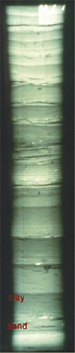
At sea level lowstands as occurred at the Latest Pleistocene glacial maximum, the red zone in Figure 2-3 represents zone of the upper continental slope gas hydrates that would decompose. This process produces large volumes of methane that are transferred to the water column and atmosphere. Sediment instability leading to large-scale shelf-edge submarine landslides is a by-product of gas hydrate decomposition. Figure 2-4 illustrates the seaward displacement of a fluvial and deltaic deposition system to the shelf-edge accompanying a lowering of sea level as occurred many times during the Pleistocene. Note the zone of the upper continental slope where gas hydrate deposits become unstable because of the reduction of hydrostatic pressure and an increase in water temperature. Slope failures leading to canyon formation can occur. Slumps and density underflows feed slope and deep basin floor fans. Lithology of the Lagniappe Delta (Figure 2-6 – 2-11)
Migratory Pathways and Reservoir-Charging Leakage (Figures 2-12 – 2-17)
Figure 2-12 is a regional seismic profile that demonstrates the thin connective beds (turbidite deposits) between the up-dip shelf-edge delta and a down-dip channel-levee system. The inset figure shows a seismic profile across the Stage 2 Lagniappe delta at the present shelf-edge and an underlying Stage 8 delta. Cores through both deltas indicate sand-rich clinoforms. Potential migration pathways up the heterolithic clinoform toes are illustrated. Figure 2-13 is a high resolution seismic profile along strike CSI line 3 showing the Lagniappe oxygen isotope stage 2 delta onlapping an older clinoform wedge to the east. Note the surface irregularities on the delta lobe. These irregularities represent carbonate buildups on exposed and truncated clinoforms. The side-scan sonar images (two inset images) clearly show linear carbonate hardgrounds on the tops of eroded clinoforms. These are the sites of gas seeps observed as bubble trains in the water column both on seismic records and echo-sounder profiles. Gas is escaping from the porous and permeable sand-rich clinoforms. In Figure 2-14 a dip-oriented seismic reflection profile from a buried shelf-edge delta, defined as a clinoform wedge, is linked to its associated down-dip leveed channel (channel A on adjacent slope image). This relationship is common along the northeastern Gulf of Mexico continental margin. The inset in Figure 2-14 is a schematic diagram of a shelf-edge delta, canyon-slope channel, down-dip channel-levee complex, and slope gullies. The metrics associated with this diagram are typical of delta-to-leveed channel systems along the northeastern Gulf of Mexico shelf-slope transition (Posamentier, 2003). Figure 2-15A is an isochron map of the levees associated with slope channel (B). The low sinuosity of the channel likely was associated with the formation of these levees; their thickness reaches a maximum of 80 m. The levee tops are illustrated in the perspective view in Figure 2-15B. The transverse seismic reflection cross section in Figure 2-15C clearly illustrates a buried channel-levee morphology (Posamentier, 2003). Figure 2-16A is a perspective view of a reflection amplitude map near the lower boundary of the slope channel system. A single leveed channel is observed to be attached to a frontal splay as suggested by the fan-shaped spread of high amplitude reflections down-system from the transition point (T). The reflection pattern within the frontal splay (Figure 2-16B) suggests the presence of a distributive channel network. The entire system is ultimately traversed by an entrenched channel (Posamentier, 2003). High-resolution seismic lines CSI line 8 and COMSSRC line 2 (Figure 2-17) illustrate truncated clinoforms at a subsea elevation consistent with the generally accepted -120 m for sea level at the LGM. Stratigraphic relationships, in CSI line 8, indicate that the clinoforms at approximately -120 m postdate the shallower and upslope clinoform set dated at ca. 19 ka. Note the high amplitude reflection patterns in the lower parts of the clinoforms in Figure 2-17. These patterns are interpreted as the presence of bubble phase gas. Growth Fault-Gas Hydrate Conveyor Belt Growth Faulted Shelf Margin (close-up view) (Figure 3-1)
Growth Faulted Shelf Margin (expanded view) (Figure 3-2)
Recent studies of the shelf to slope transition in the northern Gulf of Mexico have demonstrated that the shelf edge is constructed largely of laterally offset and stacked deltas. Where core data are available, these deltas display excellent reservoir quality. Based on current studies, they are considerably more sand-rich than their high-stand counterparts. High-resolution seismic reflection profiles frequently display the high amplitude and blanking effects of gas in the lower portions of associated clinoform sets. Also gas is frequently observed in the water column on seismic and echo sounder records above shelf edge deltas. These sand-rich clinoform packages, frequently down-thrown to active growth faults, were deposited during periods of falling to low sea level. In a previous study we demonstrated that shallow salt masses may focus the migration of fluids and gasses from the deep subsurface into shallow stratigraphic units including heterolithic turbidites that are connected updip to the shelf edge deltas. In this poster we present a more general model involving the formation and decomposition of gas hydrates within deltaic reservoirs, with or without links to deep-seated thermogenic sources. In the general case, shelf edge deltaic depocenters are linked by heterolithic clinoform toes to oxygen deficient continental slope sediments that have the potential to generate methane through microbial decomposition of organic matter. This model defines a shelf edge delta gas hydrate-growth fault “conveyor belt” gas charging system. The cyclic deposition of successive lowstand deltas drives the downward displacement of reservoir quality sand bodies along the fault. In their journey down the growth fault, any given sand body will be first above the gas hydrate stability zone (GHSZ), and subsequently within and below the GHSZ. The shelf edge delta gas hydrate growth fault conveyor belt is capable of collecting large volumes of gas at shallow stratigraphic depths above the hydrate stability zone, fed from linked down dip sources. Movement of the delta down the fault into the GHSZ incrementally sequesters gas in a condensed form within the reservoir sands. The gas is thus stabilized within the reservoir and the porosity and permeability of the reservoir is also stabilized and protected from early diagenesis. Following additional displacement down the fault the reservoir emerges below the base of the GHSZ causing the gas hydrate to dissociate into a readily available source of over pressured gas. Potential migration of this over pressured gas up and down the growth fault may charge both up-thrown and down thrown reservoir strata. In the Gulf of Mexico it is unlikely that reservoirs would be charged with purely biogenic gas. It is more likely that deep-seated faults and salt bodies provide conduits for thermogenic fluids and gases to enter the shelf edge delta gas hydrate-growth fault conveyor belt system.
Anderson, J.B., A. Rodriguez, K. Abdulah, L.A. Banfield, P. Bart, R. Fillon, H. McKeown, and J. Wellner, 2004, Late Quaternary stratigraphic evolution of the northern Gulf of Mexico: A synthesis, in J.B. Anderson, and R.H. Fillon, eds., Late Quaternary Stratigraphic Evolution of the Northern Gulf of Mexico Basin: SEPM Special Publication No. 79, p. 1-24. Beaubouef, R.T., V. Abreu, and J.C. Van Wegoner, 2003, Basin 4 of the Brazos-Trinity slope system, western Gulf of Mexico: The terminal portion of a late Pleistocene lowstand systems tract, in H.H. Roberts, N.C. Rosen, R.H. Fillon, and J.B. Anderson (eds.) Shelf Margin Deltas and Linked Downslope Petroleum Systems: 23rd Annual GCSSEPM Foundation Bob F. Perkins Research Conference, p. 45-66. Berg, R.R., and A.H. Avery, 1995, Sealing properties of Tertiary growth faults, Texas Gulf Coast: AAPG Bulletin, v. 79, p. 375-392. Cathles, L.M., 2001, Capillary seals as a cause of pressure compartmentation in sedimentary basins: Proceedings GCSSEPM Foundation 21st Annual Research Conference, Petroleum Systems of Deep-Water Basins, December 2-5, p. 561-572. Erendi, A. and L.M. Cathles, 2001, Gas capillary inhabitation to oil production: Proceedings GCSSEPM Foundation 21st Annual Research Conference, Petroleum Systems of Deep-Water Basins, December 2-5, p. 597-608. Fillon, R.H., H.H. Roberts, and B. Kohl, 2000, Stratigraphic framework and origin of shallow geohazards on the upper slope, northeastern Gulf of Mexico: Proceedings 32nd Annual Offshore Technology Conference, OTC Paper 12073, p. 1-14. Fillon, R., B. Kohl, and H.H. Roberts, 2004, Late Quaternary deposition and paleobathymetry at the shelf edge slope transition, ancestral Mobile River delta complex, northeastern Gulf of Mexico, in J.B. Anderson and R. Fillon (eds.), Late Quaternary Stratigraphic Evolution of the Northern Gulf of Mexico Basin, SEPM Special Publication No. 79, p. 109-140. Hamilton, P., 1990, Deep current in the Gulf of Mexico: Journal of Geophysical Research, v. 20, p. 1087-1104. Kennett, J.P., K.G. Cannariatato, I.L. Hendy, and R.J. Behl, 2003, Methane hydrates in Quaternary climate change The clathrate gun hypothesis: American Geophysical Union, Washington, D.C., 216 p. Kohl, B., R.H. Fillon, and H.H. Roberts, 2004, Foraminiferal biostratigraphy and paleoenvironments of the Pleistocene Lagniappe delta and related section, northeastern Gulf of Mexico, in J.B. Anderson and R. Fillon (eds.), Late Quaternary Stratigraphic Evolution of the Northern Gulf of Mexico Basin, SEPM Special Publication No. 79, p. 187-216. Kohl, B., R.H. Fillon, and H.H. Roberts, 2003, Biostratigraphy of a Pleistocene shelf-edge delta system, northeastern Gulf of Mexico: Recognition of delta subenvironments, in H.H. Roberts, N.C. Rosen, R.H. Fillon, and J.B. Anderson (eds.) Shelf Margin Deltas and Linked Downslope Petroleum Systems: 23rd Annual GCSSEPM Foundation Bob F. Perkins Research Conference, p. 785-816. Kolla, V., R.H. Fillon, H.H. Roberts, B. Kohl, and B. Long, 2003, Late Pleistocene sequence stratigraphy of the shelf-edge and upper slope in the Viosca Knoll Area of the northeast Gulf of Mexico, in H.H. Roberts, N.C. Rosen, R.H. Fillon, and J.B. Anderson (eds.) Shelf Margin Deltas and Linked Downslope Petroleum Systems: 23rd Annual GCSSEPM Foundation Bob F. Perkins Research Conference, p. 79-90. Kvenvolden, K.A. and T.D. Lorenson, 2001, The global occurrence of natural gas hydrate, in C.K. Paull and W.P. Dillon, Natural Gas Hydrates, Occurrence, Distribution, and Detection: American Geophysical Union Geophysical Monograph 124, p. 3-18. Labeyrie, L.D., J.C. Duplessy, and P.L. Blanc, 1987, Variations in mode of formation and temperature of oceanic deep waters over the past 125,000 years: Nature, v. 327, p. 477-481. Posamentier, H.W., 2003, A linked shelf-edge delta and slope-channel turbidite system: 3D seismic case study from the eastern Gulf of Mexico, in H.H. Roberts, N.C. Rosen, R.H. Fillon, and J.B. Anderson (eds.) Shelf Margin Deltas and Linked Downslope Petroleum Systems: 23rd Annual GCSSEPM Foundation Bob F. Perkins Research Conference, p. 115-134. Posamentier, H.W., G.P. Allen, D.P. James, and M. Tasson, 1992, Forced regressions in a sequence stratigraphic framework: Concepts, examples, and exploration significance: AAPG Bulletin, v. 76, p. 1687-1709. Roberts, H.H, J. Sydow, R.H. Fillon, and B. Kohl, 2003, Late Quaternary shelf-edge deltas from northeastern Gulf of Mexico and eastern Borneo (Indonesia): A comparison, in H.H. Roberts, N.C. Rosen, R.H. Fillon, and J.B. Anderson (eds.) Shelf Margin Deltas and Linked Downslope Petroleum Systems: 23rd Annual GCSSEPM Foundation Bob F. Perkins Research Conference, p. 843-848. Roberts, H.H. and J. Sydow, 2003, Late Quaternary stratigraphy and sedimentology of the offshore Mahakam Delta East Kalimantan (Indonesia): tropical Deltas of Southeast Asia- Sedimentology, Stratigraphy, and Petroleum Geology, SEPM Special Publication No. 76, p. 125-145. Roberts, H.H., R Fillon, B. Kohl, J. Robalin, and J. Sydow, 2004, Depositional architecture of the Lagniappe (Mobile River) delta: Sediment characteristics, timing of depositional events, and temporal relationship with adjacent shelf-edge deltas, in J.B. Anderson and R. Fillon (eds.), Late Quaternary Stratigraphic Evolution of the Northern Gulf of Mexico Basin, SEPM Special Publication No. 79, p. 141-186. Sassen, R., S.T. Sweet, a.V. Milkov, D.A. DeFreitas, M.C. Kennicutt, II, and H.H. Roberts, 2001, Stability of thermogenic gas hydrates in the Gulf of Mexico: constraints on models of climate change: in C.K. Paull and W.P. Dillon, Natural Gas Hydrates, Occurrence, Distribution, and Detection: American Geophysical Union Geophysical Monograph 124, p. 131-143. Shackleton, N.J., 1987, Oxygen isotopes, ice volume and sea level: Quaternary Science Reviews, v. 6, p. 183-190. Shosa, JD. And L.M. Cathles, 2001, Experimental investigation of capillary blockage of two phase flow in layered porous media: Proceedings GCSSEPM Foundation 21st Annual Research Conference, Petroleum systems of Deep-Water Basin, December 2-5, p. 725-740. Sness, E., M.E. torres, G. Bohrmann, R.W. Collier, J. Greinert, P. Linkea, G. Rehder, A. Trehu, K. Wallmann, G. Winckler, and E. Zuleger, 1999, Gas hydrate destabilization: enhanced dewatering benthic material turnover, and large methane plumes at the Cascadia Convergent margin: Earth and Planetary Science Letters, v. 170, p. 1-15. Suter, J.R., and H.L. Berryhill, Jr., 1985, Late Quaternary shelf-margin deltas, northwest Gulf of Mexico: AAPG Bulletin, v. 69, p. 77-91. Sydow, J. and H.H. Roberts, 1994, Stratigraphic framework of a late Pleistocene shelf-edge delta, northeast Gulf of Mexico: AAPG Bulletin, v. 78, p. 1276-1312. Winker, C.D, 1996, High resolution seismic stratigraphy of a late Pleistocene submarine fan ponded by salt-withdrawal minibasins on the Gulf of Mexico continental slope: Proceedings 28th Annual Offshore Technology Conference, OTC Paper 8024, p. 619-628. Winker, C.D., and R.C. Shipp, 2003, Sequence boundary ambiguities in shelf-margin deltas and the shelf-slope transition: Illustrations from the Pleistocene of the Gulf of Mexico, in H.H. Roberts, N.C. Rosen, R.H. Fillon, and J.B. Anderson (eds.) shelf Margin Deltas and Linked Downslope Petroleum Systems: 23rd Annual GCSSEPM Foundation Bob F. Perkins research Conference, p. 309-311. |