 Click to view posters in PDF format.
Poster 1 (5.4 mb) Poster 2 (0.9 mb) Poster 3 (25.0 mb)
Poster 4 (21.1 mb) Poster 5 (4.2 mb) Poster 6 (55.0mb)
Right click on each poster to download it.
PSThe Role of Active Structural Growth in Controlling Deep-Water Reservoir Systems and Petroleum Prospectivity in the Confined Gulf of Lion Basin, Western Mediterranean
By
Roman S. Ianev1, Nathalie Bordas-Le Floch1, John R. Underhill2, and Richard J.W. Bunt1
Search and Discovery Article #10124 (2007)
Posted May 8, 2007
Adapted from poster presentation at AAPG Annual Convention, Long Beach, California, April 1-4, 2007
1Melrose Resources plc, Exchange Tower, 19 Canning Street, Edinburgh, EH3 8EG, U.K. ([email protected])
2Grant Institute of Earth Sciences, School of Geosciences, The University of Edinburgh, King's Buildings, West Mains Road, Edinburgh, EH9 3JW, U.K.
The interpretation of a recently acquired regional 2-D seismic survey and its integration with onshore field exposures in neighbouring parts of Southern Europe has led to renewed exploration interest in Neogene (Mio-Pliocene) deep-water reservoir plays in the confined Gulf of Lion Basin in the Western Mediterranean. It can now be shown that the basin originated in the Oligocene as a syn-sedimentary extensional back-arc system that included the analogous Sarcidano Basin of Sardinia.
Subsequent Miocene-Recent post-rift subsidence was allied to increasing sediment supply due to increased run off from the developing Alpine and Pyrenean mountain belts. As a result the basin became increasingly dominated by turbiditic deposition as part of an upward-shoaling succession during the Miocene.
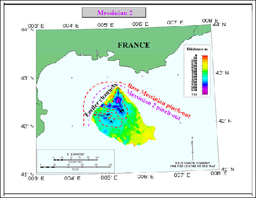
The basin fill subsequently records a dramatic shallowing episode during the Late Miocene (Messinian) in response to desiccation of the Mediterranean Sea with the development of deeply incised canyons in proximal areas and thick evaporite deposits in the offshore.
Post-rift sedimentation resumed on the margin following Pliocene transgression. Burial and tilting triggered decollement on the mobile Messinian evaporites and down-slope movement of the Plio-Quaternary sediments with the formation of a spectacular linked extensional-translation-compressional system of normal faults and folds with concomitant effects on sedimentation. Interpretation of seismic facies demonstrates how active structural growth of the mobile evaporite system controlled sediment dispersal patterns and petroleum prospectivity in the sub-salt and supra-salt turbidites. Furthermore, basin subsidence and modelling of the source rock maturation histories has provided a testable model of the newly identified play opportunities.
|
|
(Figures 1RS-1 - 1RS-2)
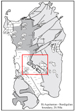
The Gulf of Lion is a major sedimentary depocentre that lies in offshore French waters of the Western Mediterranean between the Riviera Coast and the islands of Corsica and Sardinia.
(Figures 1GS-1 - 3-1)
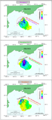
The basin was formed as a result of Oligo-Aquitanian rifting in a back-arc setting, as subduction took place between Europe and Apulia during the latter stages of Alpine collision (Figure 1GS-1). The integration of structural and palaeomagnetic data demonstrates that syn‑sedimentary extension was limited to more north‑easterly areas and did not affect the area between the Spanish Coast and the southern Balaeric Islands (Majorca and Ibiza). Consequently, significant anti-clockwise rotation (>40 degrees) characterised the Gulf of Lion during early Miocene times (21.5-14 Ma - Figure 1GS-2). Rotation was accompanied by significant thinning of the continental crust and the development of quasi oceanic crust in more distal (central) parts of the basin (Figure 1GS-3).
Rift Tectonics and Eustatic Control on Sub-Salt Deposits (Figures 4RT-1 - 4RT-3)
Insights and Lessons from the Sarcidano Field Analogue (Figures 4S-1 - 4S-4)
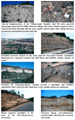
Stratigraphic sequences of Paleogene and Neogene age (Figure 4S-1) outcrop extensively on the Italian island of Sardinia (Figure 4S-2) and provide important insights both into the syn- and post‑rift evolution of the Gulf of Lion but also the reservoir potential and potential risks in the basin. The key exposures lie in and around the major NW-SE trending Sarcidano Basin (Sowerbutts and Underhill, 1998; Monaghan, 2001; Figure 4S-1). The stratigraphic succession is characterised by rapid temporal and spatial, facies, and thickness changes especially in the early stages of Oligo-Miocene extensional basin development (Sowerbutts and Underhill, 1998). This may be best exemplified in the central area where contemporaneous alluvial, shallow marine clastics, fault-block carbonates, and volcanoclastic (ignimbritic flows) all co-exist (Figure 4S-3). Their distribution and sedimentary character appears to be governed by competing extensional faulting, sediment supply, and volcanic processes (Figure 4S-4).
Messinian Salinity Crisis in the Western Mediterranean (Figures 5M-1 - 5M-3)
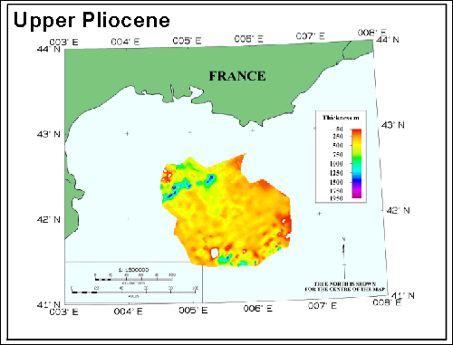
Salt Tectonic Control on Late Neogene Supra-Salt Deposits (Figures 6-1 - 6-7)
Implications for Hydrocarbon Prospectivity
Dos Reis, A.T., Gorini, C., and Mauffret, A., 2005, Implications of salt-sediment interactions on the architecture of the Gulf of Lions deep-water sedimentary systems - western Mediterranean Sea: Marine and Petroleum Geology, v. 22, p 713-746. Gattacceca, J., 2001, Cinematique du basin Liguro-Provencal entre 30 et 12 Ma. Implications geodynamiques. PhD, Ecole des Mines de Paris, Memoires des Sciences de la Terre no. 41, 299p. Lofi, J., Berne, S., Clauzon, G., Gorini, Christian, Ryan, W.B.F., and Steckler, M., 2004, Erosional processes and palaeo-environmental changes in the Gulf of Lion (SW France) during the Messinian Salinity Crisis (5.96-5.32 My) - The Messinian Salinity Crisis Revisited, 20-24 August 2004, Corte. Monaghan, A., 2001, Coeval extension, sedimentation and volcanism along the Cainozoic rift system of Sardinia, in Ziegler, P.A., Cavazza, W., Robertson, A.H.F., and Crasquin-Soleau, eds.: Peri-Tethys Memoir 6: Peri-Tethyan Rift/Wrench Basins and Passive Margins:. Mem. Mus.natn.Hist.nat., v. 186, p.707-734. Sowerbutts, A.A., and Underhill J.R., 1998, Sedimentary response to intra-arc extension: controls on Oligo-Miocene deposition, Sarcidano sub-basin, Sardinia: Journal of the Geological Society. V. 155, p. 491-508.
We are grateful to the following companies and persons for their contributions to the study of the Gulf of Lion and this poster preparation:
The Marine Geosciences team of IFREMER in Brest, France Alison Sowerbutts from the British Geological Survey in Edinburgh, Scotland TGS Nopec in Oslo, Norway PGL in Banchory, Scotland Gerard White from the University of Edinburgh, Scotland
|


