Characterization of Seismically Imaged Pennsylvanian Ooid Shoal Geometries and Comparison with the Modern*
By
W. Lynn Watney1, Evan K. Franseen1, Alan P. Byrnes1, Richard D. Miller1, Abdelmoneam Raef1, Stacy L. Reeder2, and Eugene C. Rankey2
Search and Discovery Article #20038 (2006)
Posted September 17, 2006
*Oral presentation at AAPG Annual Convention, Houston, Texas, April 9-12, 2006
![]() Click to view presentation in PDF format (~2.8 mb).
Click to view presentation in PDF format (~2.8 mb).
1The University of Kansas, Lawrence, KS ([email protected])
2Rosenstiel School of Marine and Atmospheric Science, Miami, FL
Abstract
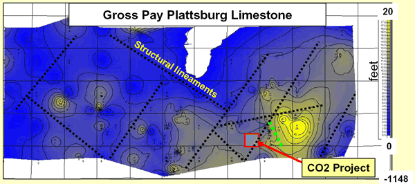
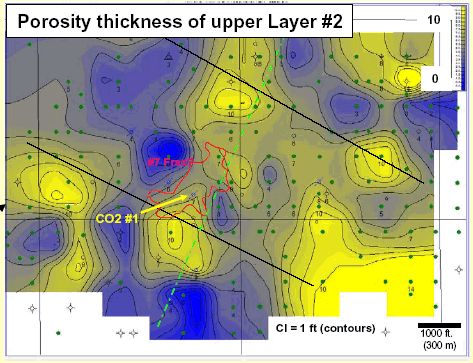
A 4-D-seismic study (Hall-Gurney Field, Kansas) is focusing on imaging and monitoring injected carbon dioxide movement within a thin (~4 m) heterogeneous Pennsylvanian Plattsburg Limestone. The reservoir consists of a 16 km x 3 km ooid shoal complex that encompasses two to three stacked, shallowing-upward cycles. Based on well logs, the succession forms 1.6 to 3.2 km2 lobes of locally porous carbonate mantling a broad paleotopographic high. Although seismic similarity facies maps are averaged over the entire thickness of stacked oolitic deposits, the images appear to show sinuous to linear, isolated pods and apparent parabolic forms within the 1.2 km2 seismic image, which are similar to geometries of individual oolitic shoal complexes in the Modern. Variations in the oomoldic pore system and geometries of beds within the oolite bodies appear to be associated with amplitude patterns. Curvature attribute seismic maps also suggest structural lineaments that may have influenced the location of depositional and diagenetic lithofacies. Core, wireline log, and CO2 flood data incorporated into a refined geomodel are verifying the seismic results. Our ability to image facies and geometric aspects of ancient subsurface ooid complexes at a scale comparable to Modern ooid complexes provides the opportunity to develop quantitative algorithms to define and predict geomorphic, granulometric, and petrophysical properties combining Modern and ancient oolitic systems. Our long term goal is to evaluate and quantify the nature of variables that control similarities and differences between oolitic depositional systems to construct object-based 3-D models that can be used to populate reservoir models.
Selected Figures


References
Dubois, Martin K., Alan P. Byrnes, and W. Lynn Watney, 2003, Field development and renewed reservoir characterization for CO2 flooding of the Hall-Gurney Field, Central Kansas: Kansas Geological Survey Open-file Report 2001-38.
Rankey, G., and S. Reeder, 2005, Processes and patterns in ooid shoals, Abaco Island Chain, Bahamas: Implications for reservoir characterization and prediction: CSL Field Trip Guidebook, Sept-Oct. - 2005, 79 p.