![]() Click
to article in PDF format.
Click
to article in PDF format.
Applying 3D Seismic to Underexplored Areas in the Uinta Basin*
By
Marc Eckels1, David Suek2, Viola Rawn-Schatzinger3, Virginia Weyland4, and Paul Harrison5
Search and Discovery Article #10097 (2006)
Posted February 6, 2006
*Modified from extended abstract prepared for presentation at AAPG Annual Convention, Calgary, Alberta, June 19-22, 2005
1Wind River Resources Corporation, Roosevelt, UT ([email protected])
2Black Coral LLC, Denver, CO 2
3CDO Technologies/DOE, Tulsa, OK
4U.S. DOE, NETL, Tulsa, OK
5Fall-Line Exploration, Inc., Silverthorne, CO
Historical Background
The Uinta Basin of northeastern Utah has long been a prolific oil and gas producer. Commercial, locally consumed natural gas production began in the basin in 1925 at Ashley Valley field near Vernal. Utah’s first commercial oil production was established from deeper formations in the same field in 1948.
Major oil company exploration efforts in the Uinta Basin commenced shortly after World War II and ultimately succeeded in discovering nearly all of the basin’s significant oil and gas fields by the early 1960s. Prior to the construction of a transportation system for natural gas in the late 1950s and early 1960s, oil was the commodity of primary interest. Even after the pipelines were built, natural gas received little attention because of the weak market and seasonal demand for gas in the Rockies.
Many exploratory wells encountered gas on the rugged south flank of the Uinta Basin during the major company exploration effort. Bar X, Westwater, Fence Canyon, Bryson Canyon, and San Arroyo fields were developed in this area early in the process because gas transportation was available on the Northwest Pipeline system a few miles to the east in Colorado. These fields, and many smaller fields in the area, produced gas from generally long-lived wells in the Cretaceous Dakota Sandstone and Cedar Mountain Formation and the Jurassic Morrison and Entrada formations, although the Entrada tended to produce low Btu gas due to contamination by carbon dioxide.
Although 2D seismic surveys were conducted throughout the Uinta Basin during the early exploration effort, no 3D seismic data were acquired until the mid-1990s, when two small seven-square-mile surveys were conducted in or near existing producing areas. Vast gas-prospective areas, largely on the south flank of the basin, received minimal attention from explorationists for many years due to the lack of oil potential, extremely rugged terrain, poor access to remote locations, difficult drilling conditions, and poor gas markets.
|
|
North Hill Creek 3D Seismic SurveyA significant and highly prospective portion of the underexplored southern Uinta Basin belongs to the Ute Indian Tribe in the Hill Creek Extension of the Tribe’s Uintah and Ouray Reservation (Figure 1). During 1999, the U.S Department of Energy solicited proposals for projects designed to encourage energy development on Indian reservations. Wind River Resources and the Ute Indian Tribe made a successful grant proposal to the DOE and received cost-share funding for a fifteen-square-mile 3D seismic survey on tribal surface and mineral lands in the Hill Creek Extension. The survey area grew to include a total of twenty-seven square miles, with most of the additional acreage consisting of split-estate lands (tribal surface overlying either state or federal minerals) that included the small Flat Rock oil and gas field, which produced from two of ten prospective geologic formations.
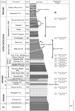
Survey DesignThe North Hill Creek 3D Seismic Survey was the first large-scale exploration-oriented 3D survey conducted in the Uinta Basin. It was designed to delineate the structure and stratigraphy of a portion of the Hill Creek anticline. The Hill Creek anticline had been previously identified in the work of John Osmond, Donald Stone, and others as a subsidiary structure associated with the Garmesa wrench fault zone, located a few miles to the north. This fault forms the north edge of the northwest-plunging Uncompahgre uplift. Although the Hill Creek anticline was noted in many publications and shown on several maps, its exact location and nature were not well understood (Figure 2). The North Hill Creek 3D survey was designed to image a geologic section ranging from the Wasatch at a depth of 2,000 ft. to the Entrada at more than 11,500 ft. (Figure 3). When the project was conceived, it was believed that the most important objectives would be shallow Wasatch Formation oil and gas and deeper gas potential in the Dakota, Cedar Mountain, and Morrison formations. Secondary objectives included stream-channel mapping in the Mesaverde Group, fracture delineation in the thick Mancos Shale section, and mapping of structural and stratigraphic traps in the eolian Entrada Sandstone. Drilling based on the interpretation of the North Hill Creek 3D data has proven each of these objectives to be gas-productive and identified additional deep objectives that were not originally considered. The additional deep objectives were sands in the Kayenta Formation and the eolian Wingate Sandstone, neither of which had been productive elsewhere. A mixed-source design was chosen due to extremely rough terrain in the survey area, a 7,500-ft. elevation mesa bounded and dissected by 1,000-ft. deep canyons. The final survey consisted of 81% Vibroseis and 19% dynamite shot-hole sources. The source lines were oriented northeast-southwest and spaced at 1,320 ft. with source points spaced at 220 ft. intervals. Receiver lines were oriented east-west and spaced 660 ft. apart with receiver stations every 220 ft. Sources were recorded into a ten-line swath with each line containing 108 channels. These parameters provided nominal 45-fold data in 110-ft. bins.
Field AcquisitionSurveying for the North Hill Creek 3D Seismic Survey began in September, 2000. WesternGeco started acquisition in late October and concluded work on December 7, 2000. Prior to the start of the survey a zero-offset vertical seismic profile (VSP) was run in an 11,600-ft.-cased hole awaiting completion at a location within the survey area.
Data ProcessingInitial processing was performed in late 2000 and early 2001 by WesternGeco’s Denver Processing Center. The data volume was reprocessed during the summer of 2002 by Precision Interactive Processing in Denver. The presence of the highly reflective Horse Bench Sandstone member of the Green River Formation at, or within a few feet of, the surface in most of the survey area made it impossible to see the data on the field records. The entire survey was shot trusting that the processors would be able to make the data usable, and they did.
Data InterpretationInitial data interpretation was greatly aided by the VSP data, as calibration issues were easily overcome. Although a gross structural interpretation was made very quickly, the original detailed interpretation effort was concentrated on the shallow Wasatch Formation, where both structural and stratigraphic traps were identified for testing. This work was performed for Wind River Resources by Black Coral LLC and Fall-Line Exploration. The data clearly imaged a northwest-southeast trending asymmetric anticline with a faulted south flank and a gently dipping north flank. This feature looks very much like the one described by Osmond and Stone decades earlier. The fault associated with the Hill Creek anticline is a deep-seated high-angle reverse fault that displaces the Precambrian through Dakota formations. The Wasatch and Mesaverde are also faulted, but by shallow faults oblique to the deeper faulting. These faults are down-to-the-south transtensional faults. Prior to seeing the first 3D data it was generally believed that the Flat Rock field was located atop the crest of the Hill Creek anticline. The seismic data show that the field is actually located on the north flank of the anticline. Del-Rio Resources’ technical staff and consultants undertook the initial deep interpretation effort, concentrating on their acreage in the northern portion of the survey area. Subsequently, the Black Coral and Fall-Line team performed a detailed deep interpretation of the entire reprocessed data volume. Both groups of geophysicists saw deep features that could best be described as sand dunes.
Drilling ResultsThe first wells drilled to test seismic anomalies were Wasatch wells in the 4,000 ft. depth range. One well was completed naturally for 1,600 thousand cubic feet of gas per day (Mcfgpd) from an obvious stream channel deposit. The second well targeted a series of sands on an apparent closed dome structure. Initially this well produced yellow oil, but it was recompleted to a shallower gas interval which became wet following hydraulic fracture stimulation. The first two deep wells drilled on the basis of the North Hill Creek 3D were Entrada wells drilled by Del-Rio Resources in the Flat Rock field. These wells located more than two miles north of the crest of the anticline confirmed that the sand-dune interpretation was correct. Significantly, they produced pipeline-quality gas. Each well was completed at approximately 2,500 Mcfgpd. During the fall of 2002 Wind River Resources and a partner embarked on a ten-well deep drilling program to explore the area along the crest of the Hill Creek anticline. All of these wells penetrated the eolian Wingate Sandstone, and Wingate completions were attempted in all but two. The best Wingate well was completed at 7,100 Mcfgpd. To date sixteen wells have been drilled and completed on the basis of the interpreted 3D data, establishing production in eleven formations ranging from the Wasatch at approximately 3,500 ft. to the Wingate at more than 12,000 ft. Some wells have certainly been better than others, but for the past three years several of these wells have consistently been among the top gas producers in Utah. Each formation imaged by the North Hill Creek 3D involves an interesting story. This presentation is focused on the gas-bearing dune sands of the Entrada and Wingate sandstones. These formations underlie a large area in the southern Uinta Basin and were previously unrecognized as important gas reservoirs.
Entrada FormationMapping of the Jurassic eolian Entrada Formation, which ranges in thickness from 200 ft. to 250 ft. in this area, has revealed multiple porous, gas-filled sand dunes separated by low-porosity and low-permeability interdune deposits. The dunes appear to be stacked as a result of dune migration in an area with a fluctuating water table. This tended to preserve the dune bases of all but the topmost layer of dunes, which appear to be fully formed. Barchan dunes, linear dunes, and large star dunes are clearly visible and appear to be separated by barren interdune mud flats. A regression analysis of the seismic amplitudes correlated with porosity-feet in the upper 70 ft. of the Entrada resulted in a correlation coefficient of 0.8831, implying that seismic amplitudes can be reliably used to map reservoir-quality sands. Production comes from several intervals in the upper two-thirds of the Entrada section. The best wells exhibit a well developed Curtis Moab Tongue immediately above the Entrada. Although the Entrada is well known as a carbon dioxide and low Btu gas producer in the San Arroyo area, at North Hill Creek and Flat Rock it produces methane with a Btu value greater than 1,000. It is likely that the Entrada is prospective over a large area in the southern Uinta Basin. Gas quality will presumably become an issue somewhere between North Hill Creek and San Arroyo, which is approximately 25 miles to the east.
Wingate FormationThe Triassic Wingate Formation was deposited as apparent linear ridge dunes. A 50-ft. thick sand near the top of the Wingate appears to be a clean gas-charged reservoir in all of the wells producing from this formation. Productive Wingate wells are located in relatively high-amplitude areas. A regression analysis similar to that performed for the Entrada resulted in a correlation coefficient of 0.9, again implying that reservoir-quality sand limits and thickness can be mapped using this tool. The best Wingate producer was drilled into a relatively high-amplitude anomaly and established an initial production rate of 7,100 Mcfgpd.
ConclusionThe North Hill Creek 3D Seismic Survey established the usefulness of this sort of survey as an exploration tool in the Uinta Basin. It was successful in delineating the planned targets and initiating a new play by illuminating new ones. To date more than 140 square miles of 3D seismic data have been acquired by six companies, and more than 100 square miles of additional survey are planned.
Stone, D. S., 1977, Tectonic history of the Uncompaghre Uplift, in H. K. Veal, ed., Exploration frontiers of the central and southern Rockies: Rocky Mountain Association of Geologists, p. 23-30. |