![]() Click
to article in PDF format.
Click
to article in PDF format.
Petroleum Mass-Balance of the Neuquén Basin, Argentina: A Comparative Assessment of the Productive Districts and Non-Productive Trends*
By
Leonardo Legarreta1, Carlos E. Cruz2, Gustavo Vergani3, Guillermo A. Laffitte4, and Héctor J. Villar5
Search and Discovery Article #10081 (2005)
Posted May 1, 2005
*Adapted from extended abstract prepared for presentation at AAPG International Conference & Exhibition, Cancun, Mexico, October 24-27, 2004.
1Patagonia Exploración, BsAs, Argentina
2Pluspetrol, BsAs, Argentina;
3Repsol YPF, BsAs, Argentina
4M&P System, BsAs, Argentina
5FCEyN-Dep. Cs.Geol., UBA-Conicet, BsAs, Argentina
Summary
The effort of eight decades of exploration and development in the Neuquén Basin (west-central Argentina) has identified a EUR of 9.7 BBOE, with a current daily production around 360 MBO and 2.6 BCFG. As result of the de-regularization and privatization process during the 90’s, the oil and gas reserves increased within the relatively mature productive tracts (Figure 1), where the known plays contain around 1.9 BBO and 17.5 TCFG of proven and probable reserves. Additional reserves are expected from testing new play concepts outside the areas under production, as well as from future activities in the under-explored fold belt and from the eastern margin of the basin (on the Pampean foreland).
|
|
Focus of StudyThis work focuses on a quantitative comparison of the known productive districts by analyzing the geological elements and the processes involved in the charge, migration, accumulation, and preservation of hydrocarbons. The quantification of the generation-accumulation efficiency of the four charge systems, known as Puesto Kauffman and Los Molles (Early-Middle Jurassic), Vaca Muerta (Late Jurassic), and Agrio (Early Cretaceous), along with the geological knowledge of the proven areas, allowed our estimate of the remaining exploratory potential (Figures 1 and 2).
Geologic HistoryThe Jurassic and Cretaceous accumulation took place within a partially enclosed marine backarc depocenter that formed on the convergent western side of the South America plate, linked to the Pacific Ocean. Relative sea-level oscillations played a critical role in the development of sources, reservoirs, and seals, governed by an extensional tectonic regime. During relative highstands a relatively shallow sea, where organic-rich shales were deposited under sub-oxic to anoxic conditions, occupied the Neuquén embayment. Under shelfal-to-nearshore and fluvial environments, carbonate and clastic high-quality reservoirs accumulated (Figure 2). Relative low position of the base level resulted in a very restricted link through the magmatic arc or complete disconnection with the Pacific Ocean. Under this new scenario, the accumulation area dramatically shrank and the backarc depocenter became a realm prone to evaporite (seal) and fluvial and eolian sandstone (reservoir) accumulation (Figure 3). The effects of the Andean compressive deformation of the sedimentary pile started to be noticeable in latest Paleocene and became very strong during the Neogene (Figure 2). However, synsedimentary deformation related to old tectonic features, present in the Paleozoic substratum, resulted in the creation of structural and combined traps very early in the tectonic evolution of the Neuquén Basin.
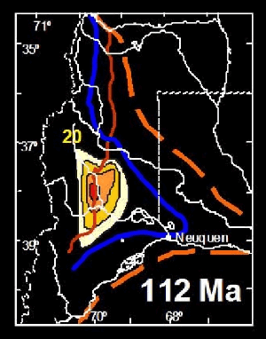
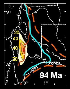
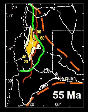
Source RocksThree high-quality and thick marine organic-rich intervals cover most of the basin (Figure 4). Additionally, a Lower-Middle Jurassic nonmarine source rock was deposited within anoxic lakes that developed within geographically restricted half-grabens (Figures 2 and 3). Modeling of the thermal evolution of the Jurassic and Cretaceous marine sources clearly indicates the existence of several episodes of hydrocarbon generation through geologic time, particularly along the west-central portion of the basin (Figures 4, 5, and 6). The overall pattern of the kerogen-transformation-ratio (TR) maps shown in Figures 4, 5, and 6 and the trends in Figure 7 depict the geographic location of the hydrocarbon kitchens of the source rocks through time and illustrate the final migration from the present deep positions to the basin margins. The timing of the process critically affected the possibility of hydrocarbon accumulation and preservation. Los Molles source rock experienced its almost entire conversion to hydrocarbons from late Early Cretaceous to Early Tertiary times, whereas Vaca Muerta evolved during the Late Cretaceous and Miocene. The late thermal evolution of Agrio covered the Eocene to late Miocene. Hydrocarbons generated in the more mature portions of the western area, therefore, experienced limited chances for accumulation and preservation in the traps formed during Tertiary tectonics. This deficiency in timing strongly disfavored hydrocarbon pools in the current fold belt (Area 1 of Figure 7), mainly those sourced from Los Molles and Vaca Muerta intervals. Conversely, trap development and adequate timing locally favored relatively higher efficiency along the fringe of the Neuquén embayment (Areas 2 and 3 of Figure 7), including the Huincul High area (Area 4 of Figure 7), where traps were developed through Jurassic and Cretaceous times.
Mass Balance EstimationsOn a generalized basis and considering the total depositional area of the three source intervals, mass balance estimations are indicative of low generation-accumulation efficiencies at a basin scale. However, when evaluations are performed on the “fetch zone” of the productive districts, each charge system portrays improved efficiencies, in line with adequate timing of source rock maturation and trap availability. The aforementioned low efficiency could indicate that most of the hydrocarbons were lost (over 97%), or at least, not preserved within commercially producible accumulations. When the analysis is performed individually in each productive district, the obtained Generation-Accumulation Efficiency (GAE) numbers show some improvement, but the total gap at the base scale is still huge. It is necessary to keep in mind that the potential resources have not been included in the calculations; they will affect the final efficiency number. Misunderstanding of the petroleum systems and possible biases in the present play concepts will have a strong implication if focus of future exploration changes; the final basin efficiency will change, as well. Based only on statistics, the yet-to-find resources are dependent on the knowledge of the producing plays, where hydrocarbon accumulations are dominated by small- to-medium-size traps. Most likely, additional reserves could be confirmed by re-appraisal of the producing fields. Other areas have geological elements indicating relatively high potential for bigger traps or/and under-explored deeper objectives. Additionally, geological data obtained from exploration wells indicate the presence of an important volume of oil retained/accumulated (?) within the Vaca Muerta basal section (Late Jurassic source rock). Up to now, few wells have had non-commercial production from that overpressured interval in the Neuquén embayment, but these observations provide encouragement to the testing of a new play. Within unexplored or under-explored areas, large pools could be provided by additional future exploration of the less investigated plays, such as in the western thrust belt, where post-mature gas generation may have charged deep reservoirs in large structures. Also, hydrocarbon resources can be envisioned within the practically unexplored deeply seated traps and basin-center gas systems (Figure 8). Finally, the potential occurrence of a heavy oil belt in the almost unexplored eastern basin edge is a challenge for non-conventional exploration (Figure 8). Besides the oil type, difficulties along some portions of this trend are related to poor or lack of information due to the presence of widespread Recent volcanic cover, which is not an unsolvable problem. |
