![]() Click to view article in PDF format.
Click to view article in PDF format.
Coalbed Methane Potential and Activity of the Western Interior Basin*
By
Steven Tedesco1
Search and Discovery Article #10059 (2004)
*Adapted from “extended abstract” for presentation at the AAPG Annual Meeting, Salt Lake City, Utah, May 11-14, 2003.
Two other articles on coalbed methane accompany this presentation; they are: Frontier Areas for Coalbed-Gas Exploration in Utah, by David E. Tabet and Jeffrey C. Quick, and Coalbed Methane Potential and Activity of the Illinois Basin, by Steven Tedesco.
1Dorado Gas Resources LLC, Englewood, CO; current address: 16746 E. Prentice Circle, Aurora, CO 80015-4130 ([email protected])
Background
The Western Interior Basin, located in Southwestern Iowa, Southeastern Nebraska, Western Missouri, Eastern Kansas, and Northeastern Oklahoma, is composed of the Cherokee Basin or Platform, Forest City Basin, and the Northeast Shelf in Oklahoma. The coals in the Western Interior Basin are Middle to Upper Pennsylvanian and generally are less than three feet thick but are laterally extensive. The primary coals of interest are in the Cherokee and Marmaton Groups of Middle Pennsylvanian age. The coals have sulfur contents, moderate to high ash values, and low moisture, and rank is medium volatile on the western side of the basin in Kansas and Oklahoma grading to High Volatile C in Southern Iowa and Eastern Missouri. Coal mining activity has been limited; it began in the early part of the last century, and most of it has been in the form of surface mines near where the coals crop out. There have been documented mine explosions in the underground mines of Eastern Kansas and Western Missouri. Economically important coal deposits in Illinois and Wyoming have limited the viability of the coal industry in the Western Interior Basin. The basin has historically produced gas from black shales or slates and coals from areas just north of Kansas City to northeast Oklahoma from as early as the 1920s. The exploitation of this resource diminished in the 1930s to an occasional completion or for providing gas for a house or local business. In the mid-1980s the revitalization of the exploitation of this resource began in Northeast Oklahoma and Southeast Kansas due Federal tax credits. However, because the coalbed methane model during this time was the San Juan and the Warrior basins, the thin nature of the coals in the Western Interior Basin, at the time, restricted gas markets, and the presence of saltwater produced from the coals limited their exploitation and development. In 2001, Devon Energy purchased a Patrick Exploration project of 100 plus wells and associated acreage in Northeast Oklahoma and an acreage project for a Denver group in Southeast Kansas, sparking renewed interest in the area. Activity in the area was further accelerated in the basin, with growing environmental opposition elsewhere to coalbed methane development, problems with water disposal, federal and state inability to permit wells, and a gas price differential that reached as high as $2.10 in July, 2002, in Wyoming, Montana, and Colorado. In the Kansas City area, which lies in the heart of the Western Interior Basin, there is a growing gas market; product prices vary between Mid-Continent and NYMEX with minimal or no differential; there is a declining product in the existing pipelines that extend from Western Kansas and Oklahoma to Kansas City and beyond; and there are friendly regulatory bodies, lack of federal acreage or involvement, and limited to nonexistent environmental activity. The play is in the early stages of exploitation. Reported gas content in the coals varies from 5 to 450 scf per ton. Gas quality varies from 96 to 98%% methane, 1% to 3%+ ethane +, 0.5&+ CO2 to 92% methane, a few percent nitrogen, and CO2 with BTU contents varying from 850 to 1050. Water rates vary from a few barrels to over 1000 barrels a day. Initial completion practices began with single-zone completions until 2002, when the State of Kansas vacated the rules preventing commingling several zones in the same well specifically being produced for coalbed methane and shale.
|
|
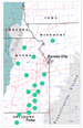
Geologic SettingThe Western Interior Basin (Figure 1) is an intercratonic depression located in Southwestern Iowa, Western Missouri, Southeastern Kansas, Eastern Kansas, and Northeast Oklahoma (Gordon and Bour, 1988). The basin is a product of Late Mississippian to Early Pennsylvanian tectonic activity that separated the Kansas Basin into two basins, the Forest City and Salina Basins in the north and created the Cherokee Basin or Northeast Shelf to the south. The Nemaha Ridge forms most of the western boundary of the basin; the northern boundary is indeterminate; the eastern boundary is the Mississippi River Arch; the Ozark Mountains are to the southeast; and the Arkoma Basin is on the south. The Nemaha Ridge is part of a failed mid-continent rift system that extends from South-central Kansas, through Southeastern Kansas, Sentral Iowa and finally to the Upper Peninsula of Michigan. The Nemaha Ridge in Eastern Kansas formed an escarpment that prevented swamp development to the west of it. Deposition during Paleozoic time in the basin was noted for limited deposition of all geologic units, accented by long periods of erosion and uplift. The basin has been the subject of on-going thermal activity and heating along the Nemaha Ridge and low temperature hydrothermal events that have migrated through the basin.
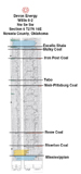
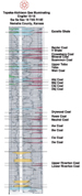
Pennsylvanian StratigraphyThe Western Interior Basin straddles five states and as such has had the stratigraphy of Pennsylvanian rocks defined by five different state agencies through time (Landis, 1965; Zeller, 1968; Murphy, 1978; Derynck, 1980; Thompson, 1995; Brenner, 1999; Hemish, 2000). The Marmaton Group and younger rocks seem to have been consistently named and correlated throughout the five states and can be tied to the Illinois Basin. The underlying Cherokee Group, is less well defined internally or between states but has the greatest thickness of coals (Figures 2 and 3). The nature of the Cherokee Group is more lower deltaic and nearshore than the overlying Marmaton Group. The lack of regional limestones is a major impediment for stratigraphic mapping as they are typically a major mapping component of a classic cyclothem. The basal section of the Pennsylvanian rocks was deposited on a karsted and erosional Mississippian surface. The Riverton coal is the first significant coal and is present predominantly in Southeastern Kansas and Northeast Oklahoma and in the center of the Forest City Basin. The next group of coals, which are more common and cover most of Kansas, Missouri, and Southwestern Iowa, is the Aw, Bw, Cw and Dw coals that lie within the McClouth-Warner depositional system. The McClouth-Warner system is overlain units characterized by a period of peat development and nearshore, quiet-marine deposition that resulted in the Drywood, Rowe, and Neutral coals. These coals may be absent in areas where Upper McClouth or overlying Bartlesville-Bluejacket sand channels are present either by erosion or non-deposition. The Bluejacket or Bartlesville interval is the next overlying unit and is dominated by sandstone channel or barrier bar development in the south half of the basin along the same trend as the McClouth system. There are a series of coals identified as the Abj, Bbj, Cbj and Dbj that are associated with this system. The overlying Cabaniss interval is less clastic in nature but is dominated by the Weir-Pittsburg, Scammon, Mineral, and Croweberg coals. Many of these coals have been extensively mined throughout the basin The overlying Banzet interval or Formation represents the youngest sediments of the Cherokee Group. The common coals are the Mulky and Bevier, and in some areas the Iron Post coal is present. The Cherokee Group is overlain by the Marmaton and is defined by several classic cyclothems. The predominant coals are the Summit, Mystic, Lexington, Mulberry, Jenks, Dawson, and Laredo coals. The Summit and Lexington coals have historically produced gas in Southeastern Kansas and western Missouri.
Coalbed FeaturesThe coals of the Cherokee Group based on ASTM ranking which is derived from BTU, volatile, and moisture content corrected for a dry ash free basis is Medium Volatile in Western Kansas(?) and Western Oklahoma to High Volatile A from Northeastern Oklahoma through Eastern Kansas and into Northwestern Missouri. The BTU content varies from 13,500 to 15,500, determined on a dry ash free basis. Coal rank diminishes into Eastern Missouri and Southern Iowa to High Volatile C. Coal quality is highly variable with ash contents less than 5% to over 50%, moisture contents averaging 4% to 10% and sulfur values ranging from 2% to 11%. The coals will typically be laminated with shale partings. Coal-quality analysis has been restricted to data collected shallower than 1600 feet, and the deeper coals in the western part of the basin, based on log analysis, seem to have lower densities and maybe cleaner in nature. Published desorption Scf per ton data has been limited (Stoeckinger, 1990; Tedesco, 1992; Bostic et al., 1993). Scf per ton data that has been reported has been in the range of 50 to 450 scf per ton in the Forest City Basin and 185 to 325 for Southeastern Kansas. Adsorption data that has been reported indicate a range of 150 to 230 scf per ton using a pressure gradient of 0.43 psi/foot and calculated for the in-situ depth and temperature of the coal. The basin is reportedly to be normally pressured. Permeability measurements have only recently been taken by a number of companies new to the area. Permeability as high as 400 millidarcies has been reported on the Northeast Shelf by operators using their own injection fall-off testing methods, but these data are considered unreliable. Recent test data from Northeast Oklahoma and Southeastern Kansas have indicated a permeability range of 5 to 30 millidarcies for various coals. In the central and northern part of the Forest City Basin coals have from 1 md to 200 md with a general range of 10 to 60 md from depths of 1400 to 2350 feet. Gas quality data are limited, however; it is has been reported to be 92% to 96% methane, 3% to 5% ethane and heavier hydrocarbons, and the remainder generally CO2, with nitrogen reported locally in some cases. The gas in the productive Pennsylvanian sandstones has been reported to be sourced from the coals and shales. The gas has also been reported to be a combination of thermogenic and biogenic methane.
History and Status of ActivityIn the early 1900s Southeastern Kansas was the largest gas producing region in the country (Stoeckinger, 1990). Historically, mine explosions in underground mines were reported both in Missouri and Kansas prior to the existence of the oil and gas industry (Bartow, 1906). The shale gas industry was started in the 1920s and 1930s in Eastern Kansas and Missouri as a result of depletion if conventional sandstone channels. Historically wells have produced in Eastern Kansas, Western Missouri, and Northeastern Oklahoma. In the late 1980s and early 1990s because of Federal tax credits the industry received renewed life (Stoeckinger, 1990; Stoeckinger, 2000). The area of focus was Southeastern Kansas in Wilson, Labette, Neosho, Chautauqua, and Montgomery counties and in Oklahoma in Craig, Washington, and Nowata counties. In 2001 Devon Energy bought an existing project from Patrick Exploration of Tulsa, Oklahoma, and an acreage package located in Southeastern Kansas. This caused an ever increasing interest in Eastern Kansas and Northeastern Missouri, with leasing and drilling activity. Spacing of wells is on 40 to 160 acres depending upon the operator. Production rates vary from 5 to over 500 MCFGPD and water rates of 5 to over 1000 barrels of water a day. Peak water rates usually occur in the first six months and peak gas production occurs in the same time frame with a 1% decline per year after that. The present play, taking into account all of the potential coal bearing lands in the Western Interior Basin (Figure 4), is in excess of 22 million acres. The potential coalbed methane resource for this area is generally defined by the presence of four or more seams in the Cherokee Group. It has yet to be determined how many of these coal seams in an individual well can be completed and produced. Individual well reserve estimates have varied from as little as .1 BCF per 160 acres to over .5 BCF per 80 acres. The water quality in the Cherokee Group is fresh water in Southern Iowa but with regional increase in total dissolved solids to salt water across most of Kansas, Missouri, and Oklahoma. The Ordovician Arbuckle provides the best disposal zone, as it will go on vacuum and take several hundred if not thousands of barrels of fluid a day. There has been no published mapping of the hydrology or water quality for the Cherokee and Marmaton coals. The land in most of the Western Interior Basin is held in fee. The play is estimated to be approximately 22 million acres in size, extending from Southern Iowa to Northeastern Oklahoma. There is a very small amount of Indian and Federal acreage present in the play. There are also at least two major cities, Kansas City and Tulsa, that lie in the basin. There has been little if any opposition to date to the oil and gas, mining, and coalbed-methane industries in the region. The land is typically either in pasture or crop and most tracts vary from 40 to 240 acres in size. Land-tract size does increase from east to west. Presently, there are over 50 companies leasing in the basin. There are at least twenty companies planning to or are in the process of drilling test wells, pilot projects, or development wells.
PotentialThe negative aspects of coalbed methane exploration in the Western Interior Basin are:
The positive aspects for developing coalbed-methane in the Western Interior Basin are:
ReferencesBostic, Joy, Lawrence Brady, Mary Howes, Raymond Burchett, and Brenda Pierce, 1993, Investigation of the coal properties and the potential for coal-bed methane in the Forest City Basin: USGS, Open File Report 93-576,16p. Charles, H.H., and J.H. Page, 1929, Shale-gas industry of eastern Kansas: AAPG Bulletin, v. 13, no. 4, p. 367-381. Deason, Kenneth L., 1984, Studies of the Parkville, Prairie Point, and Riverside oil and gas fields, Platte County, Missouri: Missouri Department of Natural Resources, Open File Report 84-27-OG, 20p. Deason, Kenneth L., and Rex Bohm, 1988, Studies of the oil and gas fields of Caldwell, Clay, Clinton, and Ray Counties, Missouri: Missouri Department of Natural Resources, Open File Report 88-69-OG, 43p. Green, Frank C., 1933, Oil and gas pools of Western Missouri: Missouri Bureau of Geology and Mines, Appendix II, 57th Biennial Report, 68p. Stoeckinger, William T., 1990, Kansas coalbed methane comes on stream: Oil and Gas Journal, p. 88-90. Stoeckinger, William T., 2000, Coalbed methane completion practices on the Cherokee Platform, in Oklahoma Coalbed-Methane Workshop: Oklahoma Geological Survey, Open-File Report OF 2-2000, 51p. Tedesco, Steven A., 1992, Coalbed methane potential assessed in Forest City Basin: Oil and Gas Journal, p. 68-72. Wood, Gordon H., Jr., and William V. Bour, III, 1988, Coal map of North America:USGS, 2 map sheets, 1:5,000,000. |