![]() Click to view article in PDF format.
Click to view article in PDF format.
-
-
Time-lapse Seismic and Real Options: New Measures are Required to Show Value Creation*
-
Tore Håkon Hanssen1, Eivind Bakken2, and Lars Håkon Nordby2
Search and Discovery Article #40117 (2004)
*Adapted from "extended abstract" for presentation, entitled "What if you need seismic to understand your geological model? Exploration in the UK Southern North Sea Rotliegend Transition Zone," at the AAPG International Conference, Barcelona, Spain, September 21-24, 2003.
1Fortum Petroleum AS, Lysaker, Norway ([email protected]);
2Statoil UPN HNO HD PTEK GEO, Stavanger, Norway
Introduction
Time-lapse Seismic is repeated seismic over the same location and serves as a supplement to reservoir simulation models for identifying fluid flow.
Real Option Valuation is to appreciate the value of flexibility inherent in a project. It can be to benefit from the time flexibility of a decision or, as in this case, to identify and secure a back-up location for a high-risk drilling target.
The Challenge is that conventional management metrics, e.g. performance indicators, do not value robust planning. We seek a measurement system rewarding cases like this where production comes from a back-up target, rather than the primary target. To secure that the project teams constantly focus on robust and flexible planning, management metrics are recommended to have a better balance between cash flow monitoring and opportunity monitoring. This is increasingly important as fields mature.
|
|
Heidrun Field
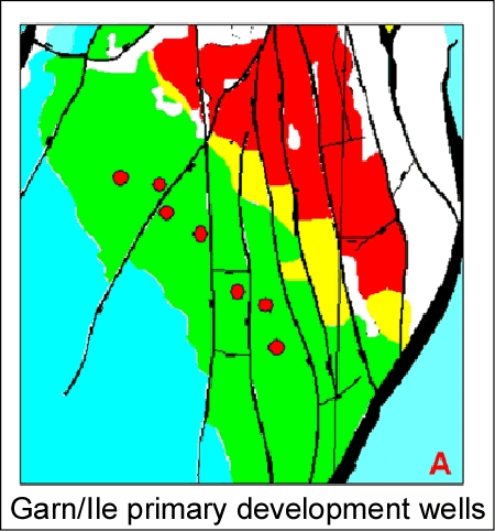
General FeaturesThe giant-sized Heidrun Field, located offshore mid-Norway, is developed with a tension leg platform (TLP) and 5 subsea templates and has produced over 500 million barrels of oil and nearly 5 billion Sm3 of gas since production start in 1995. The field is generally structurally complex, but the South Flank of the field, discussed in this paper, is dominated by North-South trending and dip-parallel, faults (Figure 1). The approximately 800 m reservoir section comprises a generally transgressive sequence ranging from continental to open marine deposits. The hitherto main production contributors, are the excellent Garn and Ile reservoirs deposited in a shallow marine setting (Figure 2).
Primary Drainage and In-fill WellsThe drainage strategy is largely based on single Garn and Ile producers in each segment for each of the two formations. Downflank water injectors and one gas injector, together with gas cap expansion, provide pressure support (Figure 3). Before production start, this drainage strategy was assumed to recover more than 60% of the oil in place in the two reservoirs (Dragsten, 1994). Updated understanding indicates that even these relatively homogeneous reservoirs give challenges and that more extensive in-fill drilling is required (Figure 4). Primary development wells target pristine conditions and the economic outcome ranges are generally all attractive. The late-life in-fill wells, on the other hand, battle the additional uncertainty of fluid movement and the economic outcome may be negative. In-fill well planning has to address possibly conflicting data like observed well behaviour, reservoir simulation results, and in this case, time-lapse seismic interpretation.
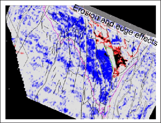
Time-lapse seismicA seismic survey was acquired downflank of the TLP (Figure 5) in 2001 and parallel processed with the 1986 seismic data from before production start. It was immediately recognised that the seismic data revealed fluid movement information as the character of seismic attributes proved consistent with the main faults and initial contacts (Figure 6). This is further presented in Furre et al, 2003.
Planning and Lessons Learned from the First Well (A-42A) A handful of well targets had been identified based on the simulation model. Acknowledging the complexity of these well targets, the Operator invited the license partners to in-depth discussions. The well targets were checked against seismic attribute and inversion data and it was decided to pursue two targets. The targets were concluded to be viable, though associated with high risk. True enough, the result from the first well showed both a more complex geology and drainage pattern than modelled, and the license partners further acknowledged the importance of risk handling when planning the second well.
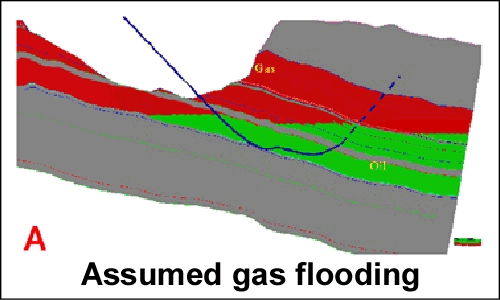
Careful interpretation of time-lapse seismic attribute data showed an area where oil in the Garn Formation appeared to be undrained (Figure 6). Reservoir simulations indicated that the area was gas flooded and that to target the underlying Ile Formation was a better alternative (Figure 7). The platform gas processing capacity currently constraints the oil production, so it is important to minimise the risk of massive gas production. This concern favoured to have the Ile Formation as the primary target. Neither the simulator model nor the time-lapse seismic had perfectly predicted the A-42A outcome, and based on the many accurate predictions from the simulation models earlier in the field's life, the simulation results were given priority over the seismic data. On the other hand, a thick, homogeneous offshore oil reservoir like the Garn Formation is the best possible candidate for seismically tracking fluid movements (De Waal and Calvert, 2003). To handle a case of conflicting data, we realised that we neither had any jointly agreed procedures between staff from different disciplines nor between the license partners. This meant that extensive, but constructive discussions were required to reach a license decision. It was finally agreed to extend the well from the primary Ile target with a pilot well to a secondary Garn target to test the reliability of the time-lapse seismic information. Results from A-30 well were that this well proved to be gas-flooded in the primary Ile target, but it was extended to discover a less flooded secondary Garn target. The A-30A producer followed to target approximately 8 MMbbl of oil reserves (Figure 8).
Preparing for Late-life OperationsUnlike the primary development wells and previous in-fill wells, A-30 had proven to be a well target with no safe downside. There had been a shift from the early-life phase of the field when revenue was predominantly a return on the initial development investment, to a late-life regime when revenue is largely a return on the knowledge capital (Figure 9). Uncertainty is traditionally regarded as undesired, and efforts are made to limit the outcome range and improve the project. This approach will work when one has a working Base Case model, but is inadequate when dealing with alternative scenarios.
Relation of This Case to Real Option TerminologyA real option is honouring the value of inherent flexibility in a project, e.g. opportunities that can be pursued and actions that can be taken (Table 1). The positive indication from the seismic was a source of opportunity, a real option. A successful well will get a lot of management attention when put on production. The enthusiasm over a good result is rarely matched by managerial requests to continually build a bank of available options. One could be misled to think that the key decision was to drill the A-30A producer after proving oil with the A-30 pilot. We argue that the true value creation was during the earlier planning stages when the license partners were battling the time-lapse seismic uncertainties, optimising the timing of seismic acquisition and drilling schedule and deciding on the pilot extension of A-30.
Conclusion and RecommendationThe A-30 well process comprises a case of real option identification, protection and exercising. Unfortunately, conventional value-based management metrics focus on annual measures like ROCE (Return on Capital Employed) and EVA (Economic Value Added), complemented by production and reserves reporting. Though important metrics, neither of these measures will capture that the plan was to drill an Ile target and that production eventually came from a different formation (Figure 10). Unless well communicated from the technical staff as well as requested by management, the story of the strength of a flexible plan will not be told. The staff?management "push-pull factor" is critical as also identified by De Waal and Calvert, 2003. We believe that E&P companies that want to be competitive in mature areas should at least qualitatively monitor the future opportunities generated, i.e. their real options portfolio.
AcknowledgmentsThe authors thank the Heidrun license partners ConocoPhillips, Fortum, Statoil and Petoro for fruitful co-operation during this project and for allowing us to publish these data.
ReferencesDe Waal, H. and Calvert, R., 2003, Overview of global 4D seismic implementation strategy: Petroleum Geoscience, February 2003. Dragsten K. et al, 1994, Drainage strategy for the Heidrun Field: SO-A-RE-003, June 1994. Faiz, S., 1999, Real-option application: From successes in asset valuation to challenges for an enterprise-wide approach: SPE 68243. Furre, A.K., Munkvold, F. R., Nordby, L. H., 2003, Improving reservoir understanding using time-lapse seismic at the Heidrun field: EAGE 2003. |


