Identifying Oil Seep Areas at Seafloor Using Oil Inverse Modeling
Mano, Manlio 1; Beisl, Carlos 1; Landau,
Luiz 2
(1)OILFINDER, Rio de Janeiro, Brazil. (2) COPPE / Federal
University of Rio de Janeiro, Rio de Janeiro, Brazil.
Introduction
The objective of the Inverse Modeling is to identify areas in the seafloor where active petroleum systems leek (seeps). The oil seeps indicate not only the presence of source rocks in the area, but also the occurrence of an active petroleum system with thermal maturation and migration of the hydrocarbons. With the precise location of identified seeps the E&P company adds a valuable knowledge of the petroleum systems in that region and therefore to the exploratory model of the area, resulting in a meaningful reduction of the exploratory risk in a search for new discoveries.
So far, oil seep studies focused only on detections of seepage slicks on the sea surface, using satellite images. However, depending on the current system at the interest region, the oil position on surface can be more than one hundred kilometers far from its origin at the seafloor. The inverse modeling complements the seep detection phase. Using remote sensing, hydrodynamic modeling and data assimilation, the technology allows identifying the seep origin at the sea bottom (not on sea surface anymore).
The focus on seafloor is essential to accurately locate oil seeps at deep water regions. Water depths greater than 2 km, oceanic currents with opposite direction along the water column, eddies and meanders displace the oil as it goes upwards. There is the additional transport, due to strong surface currents and wind, from the time the oil reaches sea surface to the instant of its detection.
The methodology has two main steps: (1) building of the hydrodynamics at the instant of the seepage slick detection; and (2) simulation of the oil inverse trajectory from sea surface (where it was detected by the satellite) to sea bottom (where the oil is escaping). The technology was validated and then applied to a study case at Campos Basin, Brazil. The results are presented in this paper and prove the efficiency for E&P activities.
Methodology
In the hydrodynamic step, each oil slick identified on sea surface and interpreted as a seepage is associated to a three-dimensional ocean circulation and to a wind field on the date of its detection and on the previously days, varying in time in an hourly basis. The circulation is built using data assimilation into Princeton Ocean Model – POM (Blumberg and Mellor,1987). The model is set up to present the main oceanographic features in the region.
The satellite data assimilation scheme was based in Mano (2007). Sea surface temperature (sst) and elevation fields are converted into three-dimensional mass fields (temperature and salinity), that are assimilated in the model. Satellite data are propagated along the depth using statistical correlations (Ezer and Mellor, 1997) and assimilated by a nudging algorithm, which includes a weight proportional to the correlation between the parameter (temperature or salinity) at surface and at other depth layers.
After the hydrodynamics, there is a regression in time and space to estimate the trajectory of the oil between the position on sea surface and its origin on sea bottom. The inverse modeling estimates the seep area in the sea floor using information about position, date and time of detection on sea surface.
The 3D current fields and the wind fields obtained with hydrodynamic model are imported by the inverse model. Inputs to the model are: bathymetry; current and wind, varying in time and three-dimensional space, and date, time and position of the oil in the instant of detection. For each slick at least 25 simulations are performed. The seep area definition is done calculating the point where the maximum convergence occurs between the sets of solutions. Some algorithms were developed to automatically estimate these areas.
The oil inverse model was developed in a three-dimensional Cartesian Lagrangean referential. After calculated, the area is classified according to six levels of reliability from N1 (lower level of exploratory risk) to N6 (higher level of exploratory risk). This is measured according to time, hydrodynamic, geographic and geological criteria.
Validationm
The choice of the region for the validation considered oceanographic and geological aspects necessary to evaluate the effectiveness of the methodology. The chosen region presents a complex hydrodynamic and known geological features. The technology would be considered validated if after applying the inverse modeling, seeps (detected by satellite) far from each other and observed in different dates, under different hydrodynamic systems, converged to specific areas in the seafloor, presenting geological structures favorable to the escape of oil.
Almost 50% of the surface seeps converged to bottom areas. In average, there were 3.5 seeps converging for an area. The results showed that 80% of areas calculated by inverse modeling were on compatible geologic features, as faults. Besides, the methodology was able to reduce the interest area in 77 times, considering the average of the areas, and was able to refine in 8 times the selection of spots for exploration purposes. In 73% of the cases, the seep position on sea surface is out of the limits of the calculated area, confirming the importance of focus on seafloor. The methodology was considered validated.
Case Study: Campos Basin
In this study, the inverse modeling was applied to three oil seeps detected on sea surface using RADARSAT-1 images, acquired at different dates in 2002: April 6th, July 1st and August 11th. These seepages were over the pre-salt limits, in the surrounding of the geological feature of Cabo Frio Arch at Campos Basin (Fig. 1). The water depths at the slicks spots varied from 900 to 2000 m and the distance among them was up to 60 km.
For each seep, the inverse modeling goes backward in time and in three-dimensional space to simulate the oil trajectory between sea surface and its origin, at sea bottom. The trajectories converged toward a specific region at the seafloor. This output area, at sea bottom, has 53 km2 and was classified as N4. The distances between surface positions and the seafloor area varied from 31 to 86 km. The methodology was able to reduce the search region in 27 times, which means a strong impact in cost/benefit of other steps of the chain. All the three sea surface positions were out of the limits of the area calculated by the inverse modeling.
The geographic position of the calculated area is close to development fields and to significant oil reserves, as showed in Fig. 1. The three wells in the Brazilian Exploration and Production´s Database (BDEP), localized in less than 15 km from the calculated area, indicated the presence of oil. Therefore the technology, besides reducing the investigation area, was able to identify the presence of an active petroleum system.
Discussion and Conclusion
The study confirmed the potential of the inverse modeling to increase de success rate in identifying active petroleum systems and to significantly reduce the area, time and costs throughout the exploration chain.
As it is a methodology based on computational modeling and remote sensing it can be extended to any oceanic region in the world, at a very low cost when compared to the investment needs in new frontiers in ultra deep waters. The method, however, does not substitute any of the exploratory tools, but provides important information to effectively manage the resources applied in these tools, as it focuses the area of investigation.
The results evidence the need for a change in the paradigm of exploratory studies of oil seeps, into a search for targets in seafloor and not only in sea surface.
References
Blumberg, A. F.; G. L. Mellor, 1987: A description of a three dimensional coastal ocean circulation model. In: Heaps, N. (Ed.), Three-Dimensional Coastal Ocean Models. American Geophysical Union, 208p.
Ezer, T.; G. L. Mellor, 1997: Data assimilation experiments in the Gulf Stream region: How useful are satellite-derived surface data for nowcasting the subsurface fields? Journal of Atmospheric and Oceanic Technology, 14, 1379-1391.
Mano, M. F., 2007: Data assimilation into an ocean model of Atlantic southwest basin to forecast surface circulation and mesoscale features. Doctorate Thesis. COPPE/ Federal University of Rio de Janeiro, 158 pp.
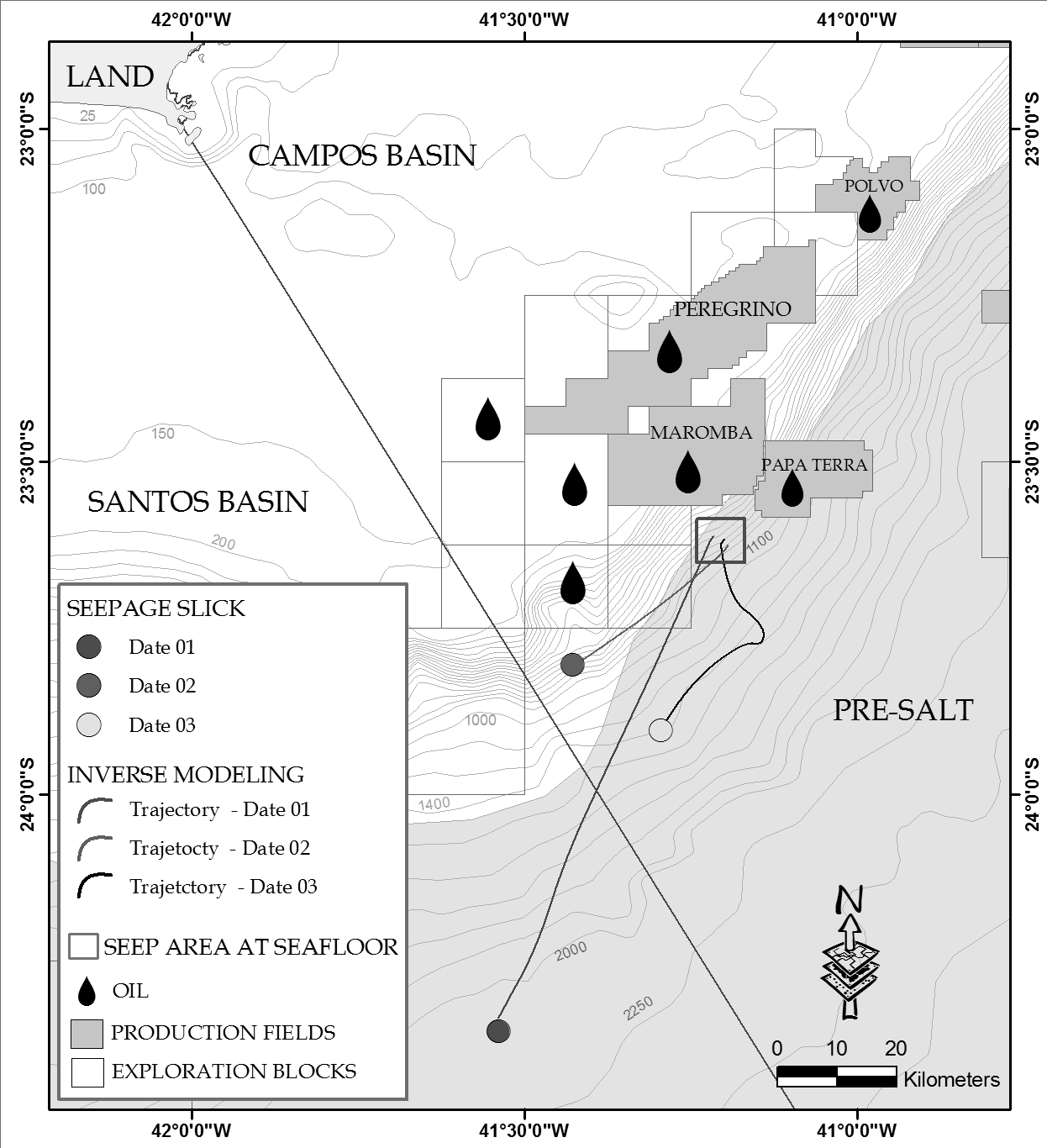 Figure 1. Identification of seep area at seafloor using the inverse modeling of three seepages slicks detected on sea surface.
AAPG Search and Discovery Article #90135©2011 AAPG International Conference and Exhibition, Milan, Italy, 23-26 October 2011.