Teachable Moments: Earth Science Events for K-12 Education
Jess B. Kozman
Carbon Lifecycle Technology Consulting, 5644 Westheimer Rd., #414A, Houston, Texas 77056
EXTENDED ABSTRACT
One way to improve and expand on geology instruction at the K-12 level is to capitalize on both everyday and extraordinary events that impact the daily lives of schoolchildren and highlight earth science topics. A recent overseas tour provided examples and the opportunity to tailor presentations for international groups of potential future geoscientists at private international schools in Southeast Asia.
Private international schools in international oil and gas centers provide an ideal laboratory for testing and fine-tuning material and methods for teaching earth science to elementary school students. The small private schools often afford unfettered access to classrooms for volunteers and local subject matter experts, small student to teacher ratios (Alspaugh, 1994) (Figure 1), and unparalleled support and participation from parents and community. In addition, teachers at these schools are often more open to augmenting their classroom plans with special programs when they are available.
This paper focuses on the period 2002 to 2006 in the countries of Brunei, China, Indonesia, Malaysia, Myanmar, Philippines, Singapore, Thailand, and Vietnam. All these countries support communities of expatriates associated with the oil and gas industry, and many participate in exchange programs through the Interscholastic Association of Southeast Asia Schools (IASAS).
One of the first opportunities to interact with grade 8 and 9 students came during a regularly scheduled Career Day sponsored by several IASAS schools. Geologists, geophysicists and petroleum engineers all participated using standard and publically available educational materials from organizations such as the Society of Exploration Geophysicists, American Association of Petroleum Geologists, and Society of Petroleum Engineers (Figure 2). After consultation with the faculty sponsors, it was decided to supplement these materials with non-proprietary materials from local companies that would illustrate the country’s particular involvement with the oil industry and earth sciences. Feedback forms collected after both sessions showed a 22% increase in positive responses from students after inclusion of the local material. Feedback from the 8th graders also gave the presenters some idea of how effective their communication had been. One of the more popular presentations on seismic acquisition by land crews elicited the following thank you notes from various students in the audience: “I always wanted to know how they knew where the oil was. I always thought they would get lucky.” “Now every time I see a hill I will think of all the money that is lying underneath it.” “You explained how you get your records. I always thought you just waited for one to happen.” “I enjoyed your thingy lesson about seismic energy thingys (sic) very much.” “Maybe some day I will see … the dynamite holes you have drilled. I promise not to crawl down in one for a souveiner (sic).” “I was one of the people who spent some money on one of those graphs of yours and I want my money.” “The way you spoke about it … made geophysicism (sic) sound really interesting.” “I thought it was funny that the cows ate the wire you used to hook the geofoams together.” “I hope whenever ya’ll (sic) drill holes or something you don’t hurt any cows or other animals, but I’m sure you know what your (sic) doing.”
Some responses probably indicate the hazards of trying to inject humor for 8th graders when describing the hazards of dynamite seismic acquisition: “The part I liked the best … how people hook the wires to the batteries of their trucks and then end up in the tree tops!” and “The saddest part was when the small forest animals were blown up to bits.” Obviously a second section on environmental and wildlife responsibility was in order there. And as a final example of the possible perils of speaking to an audience with a high percentage of children from oil field families: “You explained what a geologist does as well as my father.”
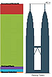
Local experts were next called in to assist with an earth sciences classroom module on geologic time, with the instructors looking for a visual analog to help explain the vast timescales required for geologic processes. Some of the standard textbook examples of condensing geologic time into a 24 hour period had gotten close, but were not visual enough for some of the learners. A local group decided on a field trip to a local architectural landmark. With a small group of 8th grade students from the local International School, we stood at the base of the 452 m (1483 ft) tall Petronas Towers, then the tallest buildings in the world. Imagine we told them that the top of the spires represented the time of the formation of the Earth (Ritger and Cummins, 1991) and that ground level was the present time. At this scale, each floor of the 88-story skyscraper represents about 50 million years. We told them that the earliest evidence of life would be found on about the 72nd floor, that the dinosaurs lived from the 5th to the middle of the second floor of the shopping center at the towers’ base, that the first Homo sapiens would appear at about the top of their ankles, and that all of recorded human history would be about the thickness of the few sheets of paper lying at their feet (Morris, 2000). This seemed to be much more impressive to the K-12 students than other analogies that had been attempted (Figure 3).
On Boxing Day (Dec. 26th) of 2004, earth scientists were presented with what was perhaps the “teachable moment” of the century. The Great Sumatran Earthquake and the Asian Tsunami that resulted from it devastated local communities, impacted students and their families directly, and saturated both traditional and next-generation news media for weeks. Local geoscientists were rushed into classrooms in the following weeks to describe in a scientific context what had happened and why, and to both clarify and amplify news stories that may have been put together with less than focused science input. The level of science expertise available to news outlets in Southeast Asian countries varied greatly during this period. The general consensus among those charged with educating K-12 students on this event was that the best format was a brief presentation on the science behind giant earthquakes, specifics of events local impact and its aftermath, followed by a question and answer session to address misconceptions or follow up concerns. The materials maintained on the U.S. Geological Survey website (see U.S. Geological Survey, 2004) (Figure 4) proved to be the most valuable for technical details of the event. Of most interest to those students who had the opportunity to attend was the large role that local geological parameters played in determining the amount of damage done by both the earthquake and the tsunami. The opportunity to examine details of local bedrock and coastal configurations for areas well known to the students from first-hand experience made the learning much more personal. Where possible, sessions were supplemented with eyewitness accounts from local community members who lived or had been traveling to impacted regions. Because of the large number of coastal communities involved and the high visibility of the sport diving community in Southeast Asia, the resources of local dive shops and tour guides were tapped to locate people who had personal accounts to share relating to the tsunami’s physical characteristics (Cable News Network, 2004). In the immediate aftermath of the earthquake, some local geosciences experts were also called in to consult with local school administrations on the relative importance of updating or, in some cases, establishing procedures for earthquake emergency drills. A scientific perspective proved very valuable in determining relative risks of major earthquakes compared with other local geo-hazards.
In the years after the Sumatran earthquake and tsunami, the involvement of local geophysical contract companies in surveys over the seismic zone provided an opportunity for longer term follow up (Singh, 2006). Special classroom topics during this period focused on the differences between seismic surveys acquired to evaluate petroleum producing reservoirs and those targeted for deep crustal analysis of earthquake mechanisms. Again this provided an opportunity to have students understand the scales at which earth scientists work and the relative subsurface depth ranges of interest for various sub-disciplines.
During this same period the problem of large landslides caused by overdevelopment of urban slopes became a news issue in several Southeast Asia countries. Many neighborhoods around local schools suffered major slope failures, some with loss of life. Local geoscientists led class discussions on the possible causes of these events, mitigation strategies, and the relationship between science and public policy. Students were asked to collect local news stories and research papers that examined the economic pressures to develop in crowded unstable areas, the relative costs of various slope stabilizing technologies, and the enforcement (or in some cases absence) of any safety requirements for contractors working in these areas, especially during monsoon seasons (Chen, 2004). Many student questions involved soil nailed retaining walls as these are very common and visible along road cuts on many Southeast Asia highways. Of particular interest to local students was the information that graduates with geoscience degrees from local universities had been employed by local government agencies to do soil studies and research slope stability. This was not evident to many students whose only contact with earth science previously had been in relation to the oil and gas extraction industries. Slobe stability in Southeast Asia was again in the news as recently as December 2008, when Malaysia's prime minister banned hillside developments after a landslide in suburban Kuala Lumpur that killed four people and forced thousands to evacuate (Agence France-Presse Newswire Service, 2008).
The publicity surrounding the pilot operation of a CO2 recovery operation at a large fertilizer plant in Malaysia (Mitsubishi Heavy Industries Limited, 2009) provided an opportunity to construct special sessions for high school science students on various geologic repositories for CO2 and the larger ramifications of greenhouse gas policies. Since many Southeast Asia countries are oil and gas producers, there was easy access to information on both the contribution of fossil fuels to anthropomorphic climate change, and the role of energy companies in investigating geologic sequestration of CO2. The idea that local national oil companies would also be involved in putting carbon back into the ground was one that had not occurred to many students, and did not at the time receive a lot of play in the media. One of the more successful exercises provided for students was to compare the policy statements on climate change provided by academic societies such as the American Geophysical Union (American Geophysical Union, 2008) and those of trade organizations such as the American Association of Petroleum Geologists (American Association of Petroleum Geologists, Division of Professional Affairs, 2007). The students were asked to compare the selective use of data and the wording of conclusions in the context of the organization’s vested interests, an exercise that demonstrated the need to understand data sources and their potential biases.
Because many Southeast Asia international schools are in national capitals that are also the headquarters for National Oil Companies, the activities of these companies and resources made available by their public relations groups were readily available. The national oil company of Malaysia, PETRONAS, for example, sponsors an interactive Science Discovery Centre that presents the science and technology of the petroleum industry in Kuala Lumpur’s downtown shopping center (Petrosains Sdn Bhd, 2009). Whenever possible, school presentations were followed by field trips or visits to these educational exhibits. These initiatives led to an interest in expanding K-12 earth science education in local schools through the translation of materials from professional societies into the local language, a project that is ongoing today.
Interestingly, attempts to adapt these best practices to larger public school systems in the United States have encountered obstacles in the larger size of the educational bureaucracy and a smaller relative pool of available subject matter experts. Presentations must also be carefully vetted by school officials to insure that students at this critical educational level receive factual information about “controversial” topics in the news with earth science foundations, such as the fossil record and anthropogenic increases in greenhouse gases. Recent efforts at U.S. schools have focused on providing educational materials about earth sciences that are relevant to recent news stories about changes in school curricula (American Geological Institute, 2009).
REFERENCES CITED
Agence France-Presse Newswire Service, 2008, Malaysia bans hillside developments after landslide, December 7, 2008, <http://www.google.com/hostednews/afp/article/ALeqM5jiRiUFZeGOAO8syIF7Rlg_ctUUQg> Accessed May 1, 2009.
Alspaugh, J. W., 1994, The relationship between school size, student teacher ratio and school efficiency: Education, v. 114, p. 77-94 .
American Association of Petroleum Geologists, Division of Professional Affairs, 2007, Climate change, <http://dpa.aapg.org/gac/statements/climatechange.cfm> Accessed May 1, 2009.
American Geological Institute, 2009, Evolution debate in Texas, <http://www.agiweb.org/gap/evolution/TX.html> Accessed May 1, 2009.
American Geophysical Union, 2008, Human impacts on climate, <http://www.agu.org/outreach/science_policy/positions/climate_change2008.shml> Accessed July 30, 2009.
Cable News Network, 2004, American diver underwater during catastrophe, <http://www.cnn.com/2004/US/12/29/tsunami.diver/index.html> Accessed May 1, 2009.
Chen, C. S., 2004, Failure of a soil nailed slope, <http://www.sspsb.com.my/images/GEOWEB/Publications/Failure-Soil%20Nailed%20Slope.pdf> Accessed July 30, 2009
Mitsubishi Heavy Industries Limited, 2009, MHI signs 9th technology license agreement to capture carbon dioxide from flue gas and increase urea production at fertilizer plant in Vietnam, <http://www.mhi.co.jp/en/news/story/0902041278.html> Accessed May 1, 2009.
Morris, P. J., 2000, Geologic time scale metaphors, <http://www.athro.com/geo/hgfr1.html> Accessed May 1, 2009.
Petrosains Sdn Bhd, 2009, Petrosains Discovery Centre, <http://www.petrosains.com.my/discoverycentre.html> Accessed July 30, 2009.
Ritger, S. D., and R. H. Cummins, 1991, Using student-created metaphors to comprehend geologic time: Journal of Geological Education, v. 39, no. 1, p. 9-11.
Singh, S., 2006, Seismic investigation of the Great Sumatra-Andaman earthquake: First Break, v. 24, no. 12, <http://fb.eage.org/content.php?id=27255> Accessed July 30, 2009.
Society of Exploration Geophysicists, 2009, Kids (K-12), <http://www.seg.org/SEGportalWEBproject/portals/SEG_Online.portal?_nfpb=true&_pageLabel=pg_gen_content&Doc_Url=prod/SEG-Students/Students-Kids/Kids-Welcome/kids-welcome.htm> Accessed May 1, 2009.
U.S. Agency for International Development, 2007, Global education database, <http://qesdb.usaid.gov/ged/index.html> Accessed May 1, 2009.
U.S. Geological Survey, 2004, Earthquake hazards program, historical seismicity, <http://neic.usgs.gov/neis/eq_depot/2004/eq_041226> Accessed July 30, 2009.
Wikimedia Commons, 2009, Tallest buildings, <http://commons.wikimedia.org/wiki/File:Tallest_Buildings_new.PNG> Accessed August 11, 2009.
Kozman, J. B., 2009, Teachable moments: Earth science events for K-12 education: Gulf Coast Association of Geological Societies Transactions, v. 59, p. 427-433.
|
|
|
 |
|
 |
AAPG Search and Discover Article #90093 © 2009 GCAGS 59th Annual Meeting, Shreveport, Louisiana