AAPG/GSTT HEDBERG CONFERENCE
“Mobile
Shale Basins- Genesis, Evolution and Hydrocarbon Systems”
Reservoir Distribution and Production in Mobile Shale Basins-Examples
from the Cruse Formation of
GRANT WACH1 and *CURTIS ARCHIE2
2Petrotrin,
Pointe-a-Pierre, Trinidad & Tobago,
The proximity of faults and shale diapirism appears to be a factor in production from the reservoirs of the Upper Miocene- Lower Pliocene Cruse Formation (figure 1 and 2) offshore and onshore in the Southern Basin of Trinidad. Subsurface and outcrop examples from the south coast of Trinidad will be used to demonstrate the effects of shale instability on the distribution and production from reservoirs deposited in mobile shale basins.
Outcrop studies (Siparia Point) indicate that the Cruse shale was deposited within an unstable prodelta setting, with subsequent rapid deposition of tidally-influenced deltaic sands directly above. The outcrops along the coast of the Columbus Channel are on the south flank of the Southern Range Anticline that is broken by cross faults. Onshore several paleo and active mud volcanoes affect the Cruse Formation. Offshore the crest of the Southern Anticline is marked by active mud volcanoes.
Distribution of sands is enigmatic. Sporadic drilling success and the inability to effectively correlate sands between wells, for example the Bonasse Filed (B- in Figure 2), suggests potential point source of sands and disruption of reservoirs through shale diapir intrusion, or slumping along unstable prodelta margins.
The “middle” Cruse reservoirs are generally the best producers, a good example being the Soldado Main Field (A- in Figure 2) with the greatest production from the Cruse Formation. In the Forest Reserve Field (D- in Figure 2), some reservoirs are in close proximity to shale diapirs with indications of low production. Next to large faults, such as the Los Bajos Fault, there is problematic production. For example at Point Ligoure (C- in Figure 2) the reservoirs tend to be initially overpressured leading to initial high production rates that tend to decline relatively quickly. It is unclear whether these production anomalies are due wholly to fault compartmentalization or if shale diapirism plays a role.
Sediment loading is a factor
leading to shale mobility. The early
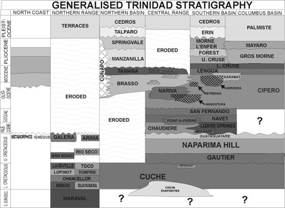
Figure 1- A generalised
stratigraphic framework for onshore
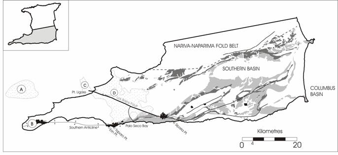
Figure 2- Surface
geological map showing the distribution of the Lower Cruse and Upper-Middle
Cruse in the Southern Basin. Major mud volcano locations and faults are
indicated. Fields that have Cruse production include A- Soldado Main, B-Bonasse,
C-Point Ligoure, and D-Forest Reserve. B- is offset slightly to the east of
the actual location for clarity (diagram
by H. Vincent from Kugler and other sources).
AAPG Search and Discovery Article #90057©2006 AAPG/GSTT Hedberg Conference, Port of Spain, Trinidad & Tobago