AAPG/GSTT HEDBERG CONFERENCE
“Mobile Shale Basins – Genesis, Evolution and
Hydrocarbon Systems”
Mobile Shale in the MacKenzie Delta - The Paktoa Shale Diapir Complex
Gavin Elsley and Peter Graham
Devon Canada Corporation
The MacKenzie
Delta is supplied with sediment from the second largest drainage basin in
Since oil and
gas exploration began in the Beaufort-MacKenzie Basin (BMB) in the 1970s ,
there have been many mud volcanoes, pock marks and ‘Pingo like Features’
observed on the sea floor, as well as many interpreted shale diapirs identified
on 2D reflection seismic profiles. A 3D seismic reflection survey acquired by
Devon
The Paktoa diapir is approximately 6km wide, up to 20km in length, and has about 4000m of present day vertical relief. It is characterized by having very little internal reflectivity, in contrast to the Taglu formation reflectors that terminate abruptly against its steeply inclined flanks (see figure 2). There are many crestal collapse features, as well as small offset faults sub-parallel to the flanks of the diapir, both of which likely formed as a result of de-watering and de-gassing of the mobile shale. The diapir was likely mainly intrusive, as there are no apparent mud volcanoes or mud flows resolvable in this seismic volume.
There are abundant seismic ‘bright spots’, which are known to correlate to shallow gas in this region. Some of these bright spots form a halo around the diapir in the immediately overlying sediments, while others are present above the crest of the diapir. The distribution of most of these shallow gas accumulations is controlled by shallow extensional faults related to movement of the diapir and fluid escape. These faults would have acted as conduits to fluid flow, but now appear to be sealing.
The source of
the shale is interpreted to be the Late Cretaceous Boundary Creek Formation,
which outcrops onshore in the
During the Eocene, Taglu deposition in the Paktoa area was influenced by extensional growth faulting, which set up a series of grabens, horst blocks and relay ramps. The greater influence of the Laramide orogeny during the Oligocene caused a large region of the BMB between the thrust front to the west and the rift margin to the East of the delta to be dominated by right lateral strike slip deformation and reactivation of many of the earlier extensional faults. In the Paktoa area (see figure 1) a releasing bend formed on one of these transtensional fault zones, which resulted in weakening of the overburden and movement up a fault plane of the Boundary Creek shale, which became the Paktoa diapir. The diapir initially moved vertically, but as it reached shallower depths and the fault tips out, it also began to move laterally along the pre-existing fault zone to the south east until it reached a restraining bend. This restraining bend formed the Paktoa/Tiggak complex, which are a pair of three way dip closures that terminate against the flanks of the diapir. Figure 1 shows the main structural elements of the Paktoa complex.
In January 2006
Devon
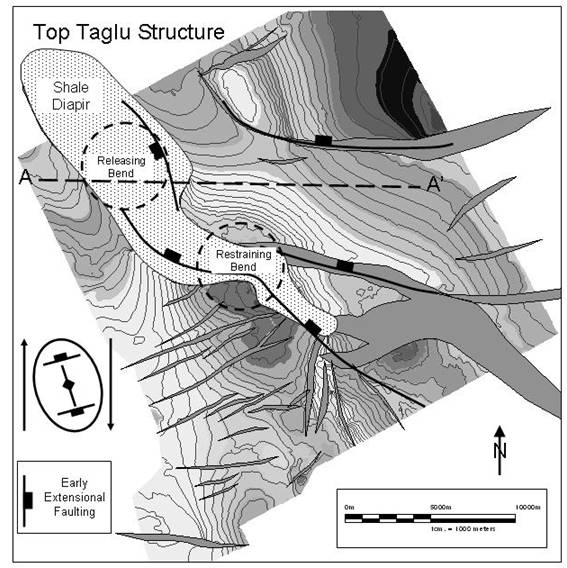
Figure 1. Top Taglu
Structure map showing the relationship between the present-day compressional
ridge and extensional faulting to the strain ellipse for a right lateral
pull-apart basin. The approximate positions of early extensional faults are
also shown.
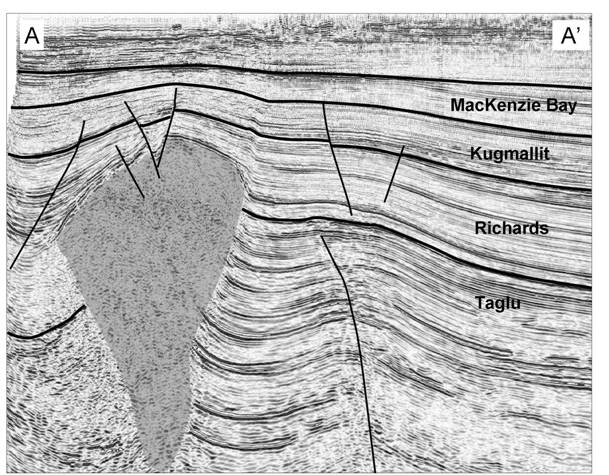
Figure 2. Seismic line through the Paktoa Shale diapir.
AAPG Search and Discovery Article #90057©2006 AAPG/GSTT Hedberg Conference, Port of Spain, Trinidad & Tobago