New Approach of Petroleum Systems Extension in Deep Water Gulf of Mexico
Mario Limón G.1, Ernesto Miranda C.1, Rebeca Navarro H.1, and María Escandón C.2
1 PEMEX Exploración-Producción,
[email protected];
[email protected];
[email protected];
2 COMESA Consultant. e-mail: [email protected]
The latest discoveries in deep water areas of countries like Brazil and the North part of the Gulf of Mexico, as well as the interest of Mexico to follow and move into the hydrocarbon exploration in water depths of more than 500m, allow the development of integrated multidisciplinary mega projects where the products generate by those could support the exploration strategies of an area.
According with this vision, the Unit of Regional Geologic Modeling of the Technical Coordination of Exploration Sub-direction of Pemex, executed the project called “Evaluation of Petroleum Systems of the Gulf of Mexico” over the period of 2003 – 2005, where personal of Pemex exploration and production, the IMP, IES and external consultants participated.
This project has been one of the most ambitious in the history of exploration in Pemex, as it covers all the extension of the South Gulf of Mexico, crossing the 14, 15 and 16 geographic zones of the UTM system, covering an area of more than 750,000 Km2. Water depths ranging from 10m up to 3800m at the center of the basin.
In order to fulfill this project, a seismic grid which covers the area of the GOM was gathered, including 346 post stack with variable filters 2D lines, as this grid is irregular due to the fact that it is composed of different acquisition surveys over the years from 1978 to 2003. As a consequence the spacing of the lines varies from approximately 30, 60 up to 100 Km, and record lengths of 8 to 12 sec. on reflect time and sampling of 4 milisec. Once the seismic information with the highest resolution was validated, 8 regional cross sections including all the wells available, were generated, in order to understand the geological and structural frame work of the GOM and show the characteristics and limits of the different geologic provinces, where the continental East shelf of Mexico was related to the West shelf of the Yucatan peninsula.
So, 16 mega-sequences of the GOM were interpreted, and correlated with 59 wells located along the continental shelf, which were selected because of their high water depth and were drilled through the longest stratigraphic sequences, been located on or close to the seismic lines allowing this the maximum control of the velocity models with logs like VSP, Check shots and sonic, for each of the units interpreted. A velocity model was built for the depth conversion of the interpreted horizons. Also, other sources for calibration, like the Deep Sea Drilling Project info (NOOA), were used.
The regional interpretation allowed to differentiate 11 structural provinces, which are genetically related defining the following systems: Burgos-Perdido, Deep Macuspana-Campeche and Campeche-Sigbee Escarpment. Which correspond to extension – contraction systems with detachment over the Jurassic salt. Quetzalcoatl-Cordilleras Mexicanas is a related extensión – contraction system detaching on the salt sequence of the Paloegene, and the Sierra de Chiapas – Akal, correspond to a thrust fold system.
Once defined the cronostratigraphic framework, the seismic facies were identified within each of the 16 mega – sequences. Within some of them several sedimentary cycles could be highlighted, but due to the regional scope of the project, generally the main reflector of each sequence was selected. The facies interpreted in the deep water units were correlated to the known facies information from the continental shelf and costal plain of the GOM. Then, facies, environmental, structural, isopac and net thickness of reservoir and source rock maps, were generated. The tectonic evolution history of the GOM, including the main tectonic elements, fault systems related to the sinrift and aperture time, as well as the limits and thickness of the oceanic, transitional and continental crust were defined according to the results of a project done by Pemex in the GOM area in 2002. It was refined with info inputs from potentiometric methods acquired recently and some additional interpretation of this project.
In order to identify possible natural oil and gas seepages based on RADARSAT -1 image texture analysis on the sea surface, it was considered the presence in time and space, the tectonic context and the environmental conditions on which a classification was generated. A confidence factor (Fc) was assigned. The shows with an Fc= 1, were grouped through clusters, with polygon shapes, and have a common point of origin in the geographic space. As a result of this method 27 clusters were classified, representing present day vertical flows of oil and/or gas, and indicate one or more active petroleum systems in the area. In this project the relationship of deep structural features and faults could be related to the clusters and the main migration pathways.
In order to define the source rocks and the oil families, the results of high end geochemical analysis technology were interpreted, using mainly analysis of the C26 Sterane compounds family, analyzed through the GCMS-MS technique, as well as the Diamondiod contend, of oil and condensates samples from wells, sea bottom piston core samples and seepages.
Considering that deep water samples could have a high percentage of contamination by biogenic organic matter related to shallow origin, which could generate organic compounds easily mistyped with those related to oil and/or gas of thermogenic origin, a sample selection methodology was defined allowing that only representative samples were selected, using filtering and eliminating low interest samples. To achieve this it was necessary to identify the bacterial origin gas samples and separate those from the thermogenic origin samples, which were selected as calibration points of the accumulations in the geologic regional models, according to the following workflow:
1- Establish if the simples are representative, considering the influence of the biogenic hydrocarbons generated by the present organic matter, which could shadow the identification of the thermogenic hydrocarbons related to deeper sources, based in the content and distribution of saturated compounds, chromatogram base lines and the Terpane and Sterane distributions. Examples were identified which show the a strong effect of biogenic hydrocarbons and biodegradation affecting the Hopane distribution, disturbing the biomarkers relations traditionally used to identify the origin of hydrocarbons, as the example of the HC30/HC29 ratio, which could lead to misinterpretation of the origin of the hydrocarbons. The absence of Sterane C26 family peeks, allow to propose them as a Noble parameter to differentiate shallow biogenic origin samples.
2- Identify the deep sources, considering the presence of the full concentration of each family of hydrocarbons and the review of the seismic lines of each sampling point.
3- Identify the hydrocarbons mixtures related to different pulses of generation, which correspond to 2 or more stacked petroleum system, based on high simultaneous Biomarkers and Diamondoid contents.
4- Identify the very mature hydrocarbons which correspond to thermogenic gas condensate hydrocarbons, having a characteristic low content of Biomarkers but high Diamondoids content. The high resolution geochemical data interpretation including GCMS-MS and Diamondoids showed to be less affected to high maturity of the samples, biodegradation processes and other alterations of the reservoir.
As a result of the application of this methodology, the GOM possible source rocks were evaluated and the distribution of the different hydrocarbons families was determined. In the GOM South region ( Veracruz, Southeast, Marine and Campeche Sound basins) the indication a complex mixture of hydrocarbons source rocks were defined flowing into the same reservoir, representing the stacking of several active petroleum systems at the present day, which represent many exploratory opportunities.
In the land North region these mixtures are not present one single source rock, e.g. the Thitonian in the land Faja de Oro of the Tampico-Misantla basin, or the Paleogene in the Burgos basin, been the geographic variations of source rock maturity are possibly responsible of the non biodegradated hydrocarbon geochemical composition changes.
The distribution of hydrocarbons of Oxfordian origin, from the North East marine region up to the Salina del Istmo area, seems to indicate a relationship with the salt structures and indicate vertical migration pathways, which are very efficient during the load and synchronism of the petroleum system. The definition of this influence on an extense geographic area could open exploration targets in the Mesozoic plays of Oxfordian hydrocarbons, which were not targeted before.
The distribution of hydrocarbons of Paleogene origin was important to identify long distance lateral and vertical migration pathways, from the regional depocenters (where the kitchen reached enough depth for the source rock maturation, in good timing with the trap generation). This could explain the origin of the gas from the Burgos basin to Lankahuasa deep and probably up to the offshore areas of Coatzacoalcos, including the coast of Veracruz, which needs to be confirmed with more detailed analysis and sampling.
The definition of the Cretaceous family from the South of the Burgos basin up to deep water areas in the Gulf to the South of the marine Faja de Oro, open expectations for exploration objectives of different hydrocarbons of Cretaceous origin which were only recognized until now in the South East and Veracruz. The importance of this new petroleum system could be very relevant in the offshore areas of the GOM were often are found mixtures of Tithonian and Cretaceous oils, seen at seepages as well as in sea bottom piston core samples.
All the tectonic, structural, stratigraphic information and geochemical analysis interpretation mentioned above, was integrated in a geographic data base system, allowing paleo-batimetry information interpretation as well the heat flow history together, highlighted the possible origin of high subsidence in certain areas of the GOM, affecting the organic matter transformation having a significant impact in the migration, filling of reservoirs and the synchronism of the hydrocarbons generated.
The numerical analysis was executed on a Basin Modeling system which allowed understanding the GOM hydrocarbon generation, expulsion and migration processes, defining the principal generation centers, migration pathways and hydrocarbon accumulations, identifying the major prospective areas, and the risk associated to those. The geographic relationship found among the thermogenic piston cores samples and the major sedimentation centers of the Upper Jurassic and Cretaceous, indicated vertical and lateral hydrocarbon migration over long distances, many associated with the salt intrusions as known in the Campeche Sound and the Perdido folded belt, through the active source rock kitchens of the present. The pre Callovian salt movement happened during the Neogene fractured the source and reservoir rocks, generating many of today’s structural traps of migrated oil and gas.
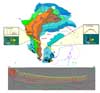 Figure 1. Oil Family distribution Map showing the correlation with seismic information
AAPG Search and Discovery Article #90062©2006 AAPG Hedberg Research Conference, Veracruz, Mexico